

29
Horizon GPS Chart400 User Manual
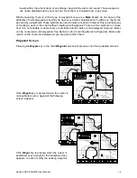
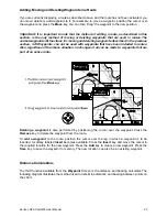
Attention Areas. Areas of importance, such and restricted anchorages and shallow areas, are
highlighted as Attention Areas. Three options are available for the display of Attention Areas, ON,
OFF and Contour. This settings is accessed from the Nav-Aids and Features Menu. The ON
option displays the attention areas as a dot pattern. Also, displayed are information (!) icons.
When the cursor is positioned over these icons more detailed information about the Attention
Areas is displayed. The Contour option removes the dot pattern and only displays the information
(!) icons. It is important to note that in some earlier CMAP chart cartridges the information (!)
icons are inactive. The final Attention Areas option, OFF, removes both the dot pattern and the
information (!) icons from the display.
Note: Detailed Attention Area information is only available from the Underway screen
and in some earlier CMAP chart cartridges the information (!) icons are inactive.
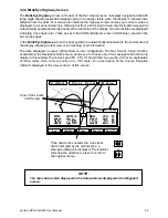
5. Track History
The Track History function allows plotting of the track of the boat as it moves. To obtain a track
history the GPS Chart400 saves the boats position to memory at regular interval. These intervals
can be time intervals or distance intervals. The Track History Menu allows the user to select
distance or time intervals and the resolution. The time intervals can be set from a minimum of 1
second to a maximum of 1 minute. The selectable distance range is from 0.01 to 10.0 distance
units.
The Track History Menu also displays the amount of available memory used to track the boat
movements and provides a memory clear function. The track plot data is retained when power is
removed from the GPS Chart400. To erase the track from the GPS Chart400 memory select
Clear Track Memory from this menu.
6. Simulation Mode
Simulation mode provides a method of becoming familiar with the GPS Chart400 functions. There
are two simulator modes to choose from. In both modes boat movement and satellite data are
simulated and all navigation functions are available. The first simulation method, Demo mode,
allows an existing route to be selected for simulation. When this mode is activated the boat will
travel along the chosen route, simulating the journey along the entire route. When the end of the
route is reached the direction of the boat is reversed and the route is traversed in reverse. The
boat will continue to travel back and forth along the route indefinitely. This simulation method is
activated as follows:
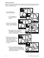
1. Create a route as described in section 3.23, Creating a New Route. Alternatively, you
may use any existing route in memory.
2. Select Simulation Mode from the Aux menu.
3. Set the Mode field to Demo.
4. Enter the desired Speed value and the Route number of an existing route.
5. Set Activate Simulation to ON.
The second simulator method, Normal mode, simulates a single leg journey. In this simulator
mode the boat continues indefinitely on the course specified. This simulation method is activated
as follows:
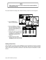
1. Select Simulation Mode from the Aux menu.
2. Set the Mode field to Normal.
3. Enter the desired Speed, Heading and Starting Waypoint values. All three fields
must contain a value to successfully enable the simulator.
4. Enter an optional Destination Waypoint. The waypoint entered in this field is used as
a destination to simulate the GoTo function. The boat will actually head in the direction
defined in step 3, Heading. It will not head toward the Destination Waypoint unless
the appropriate Heading value is entered in step 3.
5. Set Activate Simulation to ON.


