Page 6
Owner’s Manual
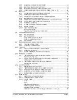
2.1.5
QUICK ACCESS TO ALARMS, TRACK AND AIS SETTINGS ................ 39
Alarms ...................................................................................................... 39
Track
...................................................................................................... 39
AIS
...................................................................................................... 39
2.2
CARTOGRAPHY OVERVIEW ............................................................................... 40
2.2.1
BUILT-IN CHARTS - For North America Users Only ................................ 40
Updating Built-In Charts ............................................................................. 40
C-MAP 4D .................................................................................................. 42
C-MAP 4D: MAX Content .......................................................................... 43
C-MAP 4D: FULL 4D Content ................................................................... 43
C-MAP 4D: Value Added Data .................................................................. 44
2.2.2
VALUE ADDED DATA MENU ................................................................... 44
2.3
REMOVING THE SD CARD ................................................................................... 44
2.4
USING FIND SERVICES ........................................................................................ 45
2.4.1
PORT SERVICES ...................................................................................... 45
2.4.2
PORT
...................................................................................................... 46
2.4.3
TIDE STATIONS ........................................................................................ 47
Changing the Day ...................................................................................... 47
Changing Tide Station ............................................................................... 47
2.4.4
WRECKS ................................................................................................... 48
2.4.5
OBSTRUCTIONS ...................................................................................... 48
2.4.6
LAKES INFORMATION ............................................................................. 49
2.4.7
QUICK AND FULL INFO ON LAKES ........................................................ 49
2.4.8
LAKES BY NAME ...................................................................................... 50
2.4.9
POINTS OF INTEREST ............................................................................. 51
2.4.10 USER POINTS ........................................................................................... 51
2.4.11 COORDINATES ......................................................................................... 51
2.4.12 INFORMATION .......................................................................................... 52
2.5
CHART DISPLAY FUNCTIONS ............................................................................. 52
2.5.1
4D FUNCTIONS ........................................................................................ 52
Chart Window ............................................................................................ 52
Display Mode ............................................................................................. 53
Overlay ...................................................................................................... 53
Overlay Mode ............................................................................................. 54
Transparency ............................................................................................. 54
3D Exaggeration Factor ............................................................................. 54
2.5.2
GENERAL CHART DISPLAY FUNCTIONS .............................................. 55
Icons Size .................................................................................................. 55
Place Names Size ..................................................................................... 55
Safety Status Bar (DSI - Data Safety Indicator) ........................................ 56
Currents Prediction .................................................................................... 56
Chart Language ......................................................................................... 57
Course Up/North Up .................................................................................. 58
Nav-Aids Presentation ............................................................................... 58
Ship Icon .................................................................................................... 58
Course Time Line ...................................................................................... 59
Compass Indicator ..................................................................................... 59
Ship Icon Position ...................................................................................... 59
2.5.3
PICTURES & DIAGRAMS ......................................................................... 60
How to Show Pictures or Diagrams of an Object ...................................... 60
2.6
CREATING MARKS ............................................................................................... 61
2.6.1
CREATING A NEW MARK ON THE CHART PAGE ................................ 61
2.6.2
EDITING A MARK OR WAYPOINT .......................................................... 61
Summary of Contents for CPN1010i
Page 1: ......
Page 144: ...CPN700i and CPN1010i Multimedia Chart Plotters Page 145 ...
Page 156: ...CPN700i and CPN1010i Multimedia Chart Plotters Page 157 ...
Page 159: ...Page 160 Owner s Manual ...
Page 163: ...Page 164 Owner s Manual 7 1 7 OPTIONAL FF525 BLACK BOX FISH FINDER ...
Page 188: ......


