19-14
19 TOP FIELD MODE
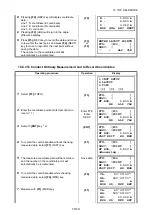
19.4.3To Conduct Ordinary Measurement and to Record Coordinates
8
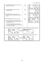
Pressing
{F2}
(NEZ) key will display coordinate
data.
Line 1: N coordinate (E coordinate)
Line 2: E coordinate (N coordinate)
Line 3: Z coordinate
Pressing
{F2}
(dHA) will return to the angle
difference display.
{F2}
9
Press
{F3}
(REC) key to record the data and move
to layout for the next point, and press
{F4}
(NEXT)
key to move to layout for the next point without
saving the data.
The number in the coordinate point will
automatically be incremented.
{F3}
or
{F4}
Operating procedure
Operation
Display
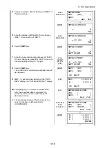
1
Select
{F3}
(TOPO).
{F3}
2
Enter the coordinate point and its description to
record. * 1)
Enter PT#,
Enter
DESC
3
Set with
{ENT}
key. * 2)
{ENT}
4
To record the coordinate data without checking
measured data, select
{F1}
(FAST) key.
{F1}
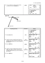
5
The measured coordinate data will be recorded,
and the number in the coordinate point will
automatically be incremented.
Save data
6
To record the coordinate data while checking
measured data, select
{F4}
(MSR) key.
{F4}
7
Measure with
{F1}
(MSR) key.
{F1}
N : 1.250 m
E : 2.500 m
Z : 0.010 m
MSR dHA REC NEXT
ENTER LAYOUT POINT#
PT#: [P02_ ]
DESC: [ ]
↑
↓
ALP CLR
1.INST SETUP
2.LAYOUT
3.TOPO
[1] [2] [3]
PT#: [ ]
DESC: [ ]
HT ROD: 1.500 m
HR ALP CLR
PT#: [P01 ]
DESC: [POINT ]
HT ROD: 1.500 m
HR ALP CLR
PT#: [P01 ]
DESC: [POINT ]
HT ROD: 1.500 m
FAST EDIT HR MSR
PT#: [P01 ]
DESC: [POINT ]
HT ROD: 1.500 m
>Measuring...
PT#: [P02 ]
DESC: [POINT ]
HT ROD: 1.500 m
FAST EDIT HR MSR
VA: 90°00'00"
HA: 120°00'00"
HD: m
MSR SD NEZ REC
VA: 60°00'00"
HA: 120°00'00"
HD: 10.000 m
MSR SD NEZ REC


