Model 2701-B
Appendix D–3
The reference stations determined a measured distance to
each satellite using the signals received from the satellites. For
each satellite, the stations compare the measured distance to
the actual range (as calculated from its known position) to
determine a differential correction for each satellite.
Two master stations, located on either coast, collect data from
the reference stations to create a GPS correction message. This
message is then broadcast through two geostationary
satellites that are in fixed position over the equator. The GPS
receiver applies the correction factors contained in the
correction message to increase the accuracy of its
measurements.
Note that the signals from the WAAS satellite may not be
available to gauge users in locations where trees, mountains,
and other large objects obstruct the view of the horizon. On
other locations, the GPS receiver may not be able to access the
signals from the three satellites required to determine a
position. As noted earlier, the gauge stores location
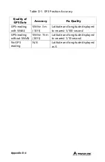
information with the results of each measurement. The
measurement display also denotes the quality of the location
fix as follows.
If WAAS information is available during a gauge
measurement, the latitude and longitude will be displayed
to the nearest hundredth (1/100) of a second.
If a GPS location is determined but the WAAS information
is unavailable, the latitude and longitude will be displayed
to the nearest tenth (1/10) of a second.
If the GPS receiver cannot determine a location, the
latitude and longitude will be denoted as
0.
C. S
PE
CIF
IC
AT
IO
NS
Summary of Contents for 2701-B
Page 9: ......
Page 20: ...1 8 NOTES...
Page 74: ......
Page 86: ...Appendix A 12 NOTES...
Page 92: ...Appendix B 6 NOTES...

