3.2 Data interface
The Survey collar is designed for long-term survival studies and therefore includes all the
necessary components.
Satellite communication:
The Survey Collar is equipped with the Globalstar satellite
modem to transmit data from the collar.
The Globalstar SIMPLEX service is a one-way only communication option and it uses a
satellite network of 48 satellites with 24 hour coverage. The GPS data are repeatedly sent
to the satellites, but no confirmation is sent by them. The Globalstar antenna is integrated
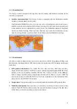
into the electronic housing. There are areas which are not covered by Globalstar yet (see
map of coverage below), so please check if your study area has Globalstar coverage.
3.3 Data format
All data is stored in binary format and can be exported as ASCII, Spreadsheet, DBase, and
BioTelemetry eXchange format. GPS data can also be exported as GPS Exchange and Google
Earth files.
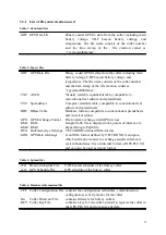
GPS position information:
No, Collar ID, UTC date and time, LMT date and time,
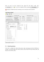
origin, SCTS date and time, ECEF X,Y and Z, latitude/longitude/height, DOP, 3D Error,
number of the used satellites, Satallite ID (Sat No), Carrier to Noise (C/No [dBHz]),
battery voltage, mortality status, temperature and last activity. Data is saved as .GDF file
and can be accessed with GPS PLUS X. For more explanation of the transmitted data,
please refer to the GPS PLUS X manual.
Temperature:
Temperature data are stored and transmitted with the GPS position data.
Mortality information:
Date and time of a mortality event based on the activity of the
animal. The GPS Plus X software stores the received mortality message in the data base.
In the Survey collar, the mortality events are not stored.
8
Summary of Contents for Vertex Plus Survey
Page 1: ...VERTEX PLUS Survey Collar Globalstar User s Manual Version 1 6 Last Change 30 08 2016 1...
Page 21: ...21...
Page 22: ...22...
Page 23: ...23...
Page 24: ...24...


