background image

Other settings in General Items-

We suggest keeping them as the default setting.


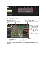
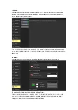
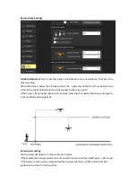
2. Offline Maps


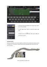
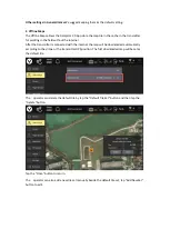
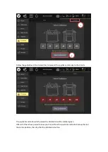
The Offline Maps allows the Datapilot 2.0 App store the map tile in the cache in the transmitter 
for working in the field without the internet.


After the transmitter is connected with the internet the map will be downloaded automatically 
according to the drone or the transmitter GPS position. The first downloaded map will be set as 
the default tile.


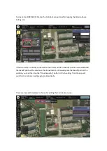
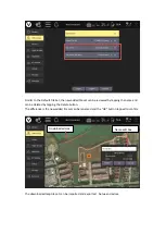
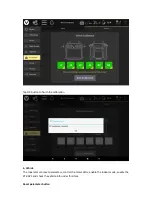
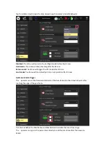
The    operator can delete the default tile by tap the “Default Tile Set” button and then tap the 
“Delete “button.


Tap the “Close” button to return.


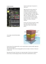
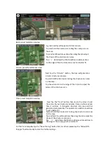
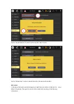
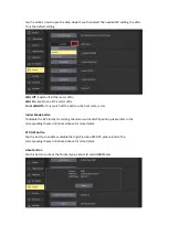
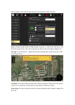
The    operator can also add a new tile set manually beside the default tile set, tap “Add New Set” 
button to edit.


Summary of Contents for H850

Page 1: ...H850 Operation Manual...

Page 2: ...E 19 SPORT MODE 19 RTL MODE 19 MANUAL MODE 19 Indoor flight 20 Go to Location flight 21 Orbit Flight 22 ROI Flight 23 Land 24 Emergency Motor Stop 24 Gimbal Control 25 Gimbal Camera Tilt Control 25 Gi...

Page 3: ...08 Gimbal Custom Type C USB Port 09 Binding Button and LED Indicator 10 Power Button 11 GMAC Port 12 Type A USB 3 0 Port 13 Micro SD Slot 14 AUX out Port 15 PWM GPIO Port 16 UART Port 17 GMAC Port 18...

Page 4: ...ight Control Stick 11 Motor Start Stop Button 12 Return to Launch Button 13 Type C USB Charging Port 14 Micro SD Card Slot 15 Headphone Port 16 HDMI Port 17 Video Record Button 18 Shutter Button 19 Gi...

Page 5: ...they shown any signs of damage swelling or inability to fully charge Plug the drone or transmitter battery into the charger port as illustrated The batteries will charge automatically Drone battery ch...

Page 6: ...l payloads of choice Insert the landing gear leg tube into the mount Secure the landing gear leg by fasten the nut Install the other landing gear leg using the same method Unfold the motor arms upward...

Page 7: ...processing Images may be captured in JPEG or DNG format or simultaneous capture of both formats Video may be recorded in UHD 2K or HD resolutions at a variety of frame rates When the Gimbal is connect...

Page 8: ...ng a closer view of objects further than the camera is able to originally see Digital zoom and optical zoom differ as optical zoom uses the placement of lenses to generate a closer image whereas digit...

Page 9: ...tap the Camera Setting Button to set more photographic parameters both for thermal imaging and visible light camera Notice Please refer to the corresponding Gimbal Operator Manual for a more detailed...

Page 10: ...gain the camera begins to increase digital zoom The digital zoom can increase to a maximum of 6X Zoom out Press and hold the Zoom out button to decrease the optical zoom When decreasing to 1X digital...

Page 11: ...4k video Using the UHS 3 card allows the camera buffer to record to the micro SD card faster resulting in fewer buffer overruns Attaching Detaching the gimbals Attaching Step 1 Find the Unlocked Mark...

Page 12: ...responding section in the OFDM Module binding chapter b Pre Flight Preparation Power ON OFF NOTICE Please make sure all firmware is the latest version Firmware can be updated via the OTA update functi...

Page 13: ...he compass in parking garages close to a building or near roads with a metal core For optimum performance only calibrate the drone in open spaces far away from power lines and other metal structures o...

Page 14: ...specific axis which is shown by the LED of each Motor Arm until a tone is heard to change to the next axis Repeat this procedure for all six positions A yellow box with a red arrow indicates the rota...

Page 15: ...default setting The H850 Drone will be positioned and navigated by using single GPS technology The RTCM Source was disabled by default under the GNSS RTK item The operator can connect the drone with...

Page 16: ...he Settings icon then tap Vehicle Select the RTK GPS and tick the Enable RTK GPS box then restart the drone Step 3 Tap the Settings icon then tap GNSS RTK Select NTRIP as the RTCM source then tick Aut...

Page 17: ...display will display a green Connected Notice Do not enable the RTK GPS when the RTCM Source is unavailable Environment Requirements Always operate the Drone in open areas approximately 10000 square...

Page 18: ...gest placing the flight switch in the middle position to use the Angel mode to take off Optimal Transmission Range The signal between the drone and the T1 Transmitter is most reliable when the antenna...

Page 19: ...e T 1 Transmitter and release it when the motors start Slowly raise the left hand stick to take off Mode 2 Shown Take Off OPTION 2 Tap the Take Off icon and set the takeoff altitude then slide on the...

Page 20: ...movements RTL MODE The Return to launch RTL function brings the drone back to the last recorded Home Point and lands automatically To enter the RTL MODE please press and hold the RTL Button on the T1...

Page 21: ...utton then select the Vehicle item and tap the Indoor Mode button Step2 Tick the Enable Indoor Flight Step 3 Push the Flight Mode Selection Switch to the Manual Flight Mode then press and hold the STA...

Page 22: ...the map Click the Go to location then the tapped point will be marked on the map as the Go here point Slide the slider the drone will fly to the Go here point on a straight flight line After arrival t...

Page 23: ...al orbit centre and radius by dragging the white dot of the orbit centre point and the radius slider After the altitude is confirmed slide the slider on the bottom to start Adjust the orbit speed radi...

Page 24: ...gimbal towards a specific point of interest on the map by directly tapping the map Select the ROI at location then slide to confirm the tapped point will be marked on the map as the ROI point After t...

Page 25: ...ency situation such as the blades could hit the people and cause serious injury Or the drone flies away under the loss control conditions which maybe be caused by a faulty sensor To force stop the mot...

Page 26: ...to the left to pan left the gimbal and Rotate the knob to the right to pan right the gimbal Keep the knob at the centre point to hold the pan direction of the gimbal Re Bind The drone and T1 Transmitt...

Page 27: ...Step 3 Power on the T1 Transmitter and tap the USYNC Button to bind Step 4 Tap the Next Button to start the binding process...

Page 28: ...Step 5 Connecting Step 6 Tap the Finish button to finish the binding process...

Page 29: ......

Page 30: ...Button Tap this button to enter the Mission Editing Interface 03 Settings button Tap this button to open the extended menu to view and adjust the parameters of other settings 04 Warning Message button...

Page 31: ...fferent communication statuses as in the picture shown below Gray The drone doesn t connect to the transmitter Red Flashing The receiver already connected to the drone and the DataPilot 2 0 App is att...

Page 32: ...f the drones GPS status To close the dialog box just tap other areas on the screen 10 Drone Battery indicator This icon displays the Remaining Power and percentage of the drone flight battery Tap this...

Page 33: ...can set the control command by using this panel After the drone takes off the panel will add 2 items as per the screenshot below 14 Drone Indicate the drone position and course The L point means the...

Page 34: ...s dial The Compass also can be switched to the gyroscopic horizon dial by tapping the dial in quick succession The Height and Horizontal Speed data will also be moved to the panel left to the dial Tap...

Page 35: ...this icon could change 3 Gimbal attitude display The Position of the Yellow dot in the gimbal tilt indicator bar shows the gimbal tilt attitude The red marks in the bar shows the gimbal is tilted up m...

Page 36: ...have recorded within a single power on time Once you have powered off the drone the counter number will be reset In the video mode the timer shows the time you have recorded in each single video shoot...

Page 37: ...he Mission Route Setting icon on the top of the DataPilot home screen The PLAN window will open allowing the operatorto create Waypoint and Survey missions sync missions between desktop T1 and the dro...

Page 38: ...of the screen If the Transmitter doesn t connected to the drone or the drone doesn t have GPS lock the operator needs to tap on the map to set the takeoff point position manually Once the Takeoff poin...

Page 39: ...Green 4 Ahead Direction Indicator This white arrow shows the forward direction of the drone along the flight route 5 Insert Button Tap to insert a waypoint before the selected one on the flight route...

Page 40: ...the camera behaviors are included After the Camera and gimbal setting menu was opened Mission Start Point Take Off Point Other Waypoints Selected Waypoint Waypoint number Terrain Altitude Delete this...

Page 41: ...een 0 flat to the ground and 90 straight down To adjust the yaw select a value between 180 left of the airframe centre line and 180 right of the airframe centre line Position Edit Menu There is a Posi...

Page 42: ...was positioned by GPS and Connected with the Transmitter The operator can tap the Move to vehicle position to make the waypoint coinside with the drone Tap the Move to previous item position to make t...

Page 43: ...a desired area To select a survey grid mission tap the Survey button after tapping the Mission Route Setting icon Then tap the Survey button on the right side of the screen to finish the further sett...

Page 44: ...edge of the survey grid for a better fit Tap the Circular button the App will generate a circular survey area Tap and hold the Centre dot to drag the survey area on the map Tap the white dot on the ed...

Page 45: ...race template please tap the Done Tracing First and then tap the Done with Polygon and other buttons Adjust the Survey parameters After the Survey area has been confirmed the operator can adjust the s...

Page 46: ...mid flight Use the Waypoint tool when variable altitudes are required Ground Res Sets the ground resolution in inches pixel which will automatically calculate and set the survey altitude Notice When t...

Page 47: ...n to lead the drone enter and exit the survey area the operator can change the enter and exit point by tapping the Rotate Entry Point button according to the actual conditions For example the enter po...

Page 48: ...oute New Enter Route Tick the Refly at 90 Degree Offset Hover and capture image After this Item is ticked the drone will stop and hover and then capture the image at each capture point for better imag...

Page 49: ...flow The s operator can type in the parameters directly in the text box for setting Display the key parameters of this survey mission Tap the Camera button beside the Gird button to select the camera...

Page 50: ...lete the survey data Tap the Presets button to save the setting parameters under the Grid and Camera Items Tap the Save Settings As New Preset button to create a new save Type the name and tap the Sav...

Page 51: ...able the drone to fly long pathways with overlap for these sorts of missions This is an example of a corridor scan After the file name was selected tap the Apply Preset button to load the parameters T...

Page 52: ...and the drone GPS position was established the takeoff point will be set above the drone location otherwise place the takeoff point at the position you need then tap the Done Adjusting button to fini...

Page 53: ...corridor scan area with 2 vertices Tap and hold the vertices dot to drag the corridor scan area on the map Tap dot allows additional vertices to be created inserted in the pathway allowing for numerou...

Page 54: ...the selected Corridor Scan mission to adjust the flight route Select the Camera As the same as the Survey mode selecting a correct camera is especially important to achieve a correct result The most f...

Page 55: ...els or output las files to products such as Revit or Autodesk workflows Structure scans may also be used for virtually any vertical scan element and may be combined with other automated flight profile...

Page 56: ...xt Tap the Circular button the App will generate a circular structure scan area Tap and hold the Centre dot to drag the structure scan area on the map Tap the white dot on the edge of the Circle to ad...

Page 57: ...cture Scan parameters After the Structure Scan area has been confirmed the operator can adjust the scan parameters Click the Grid tap under the selected Structure Scan mission to adjust the flight rou...

Page 58: ...oint flight plan The Patten flight plan such as survey etc will create a takeoff point automatically Add the waypoint on the map Add the region of interest point on the map Tap the ROI button then tap...

Page 59: ...e Mission Route Setting Button to upload the waypoint data to the drone Execute the flight mission No matter what kind of the flight plan was created to execute the operator needs to upload the plan t...

Page 60: ...mission flight mode Pause the flight mission The s operator can pause the flight mission by the following 3 method 1 Switch the flight mode by using the flight mode switch 2 Tap the Pause button then...

Page 61: ...2 Tap the Action button then select continue or set the new altitude Tap the Continue Mission button then slide to confirm to continue the mission Set the new altitude then slide to confirm Then Tap t...

Page 62: ...op up as in the picture below Tap the Resume Mission From Waypoint XX button and the mission will be updated It will delete the flight route already finished Notice It will take a few minutes to updat...

Page 63: ...er the drone and transmitter are connected to view all the items in this interface Notice Due to the DataPilot 2 0 App is a cross platform flight control application beside the H850 there are many ite...

Page 64: ...different colour schemes Indoor scheme will provide a dark interface meanwhile the outdoor has a bright interface Indoor Outdoor Map Provider and Map Type The operator can change the map provider and...

Page 65: ...e transmitter is connected with the internet the map will be downloaded automatically according to the drone or the transmitter GPS position The first downloaded map will be set as the default tile Th...

Page 66: ...centre position on the sub menu New Tile Set Name Edit Box The operator can edit the name of the new tile set in this box Map type select The s operator can select the Map provider and type in the dr...

Page 67: ...wed by tapping the name and can be deleted by tapping the Delete button The difference is the new added tile set can be renamed and the OK button tapped to confirm The downloaded map tile set can be i...

Page 68: ...utton to keep the firmware up to date After tapping the Import button select an import method then tap the Import button on the popped up dialog box and select the file to import After tapping the Imp...

Page 69: ...Radio There are 2 functions under this Item the Monitor function was the default interface when tap the T1 Radio button on the screen Monitor Move the Joysticks Knobs and Sliders or press the buttons...

Page 70: ...ticks and knobs to their limits The joysticks and knobs which passed the Calibration will be marked green After all of them have passed release your hands from the joysticks and knobs to keep them at...

Page 71: ...utton to finish the calibration 6 Vehicle The roperator can reset parameters control the motor LEDs enable the indoor mode enable the RTK GPS and check the vehicle info under this item Reset parameter...

Page 72: ...boot Now button to reboot drone then the reset will take effect LED Control In the cases of taking the aerial photography at night the motor LEDs can influence the colour effect of the photos The oper...

Page 73: ...Ds on the front motor arms Indoor Mode button To disable the GPS totally for starting the motors without GPS position please refer to the corresponding chapter introduced above for more details RTK GP...

Page 74: ...7 Summary This item displays the summary of the settings for the vehicle 8 RC Mode Tap to select the Joystick mode you wish to use...

Page 75: ...rometer we suggest to calibrate with the assistance of the nearest YUNEEC Service centre to ensure the best result 10 Safety The operator can change the drone fail safe behavior and geo fence via this...

Page 76: ...ger the RTL mode after RC Loss Land mode The drone will land directly at its current position after RC Loss Geofence Failsafe Trigger The operator can set the Radius and Altitude of the Geo fence also...

Page 77: ...it reaches the edge of the geo fence Warning The transmitter will trigger the continuous warnings when the drone reaches or flies out of the geo fence Hold mode The drone will keep hovering after it...

Page 78: ...flying back to the return point If the drone is flying higher than the RTL altitude after the RTL enabled the drone will keep the current altitude and flying back Return point setting Tap the select...

Page 79: ...ng System Android Flight Control Software DataPilot 2 0 App Operating Frequency 2 400 2 4835 GHz 5 725 5 850 GHz Transmission Protocol 2 4GHz 5GHz Transmission Power EIRP 2 4 GHz CE 18dBm FCC 29dBm 5...

Page 80: ...meter 440mm The Motor Type BL5008 The Motor KV Value 347 Battery LiHv 6s 12800mAh Charger H850 Charge Box Recharge Time 1 5 hours Position System GPS GLONASS BeiDou Galileo Hovering Accuracy Single Ho...

Page 81: ...Disclaimer...
Page 82: ...warning Damage and or injury caused by knowingly and negligibly flying with a damaged model or one which is unfit to fly e g due to dirt water penetration coarse particles oil or a model which has not...

Page 83: ...plicable laws for example in response to a court order judicial subpoena warrant or request from the government or otherwise cooperating with government agencies or law enforcement We also reserve the...

Page 84: ...dry area for best results When charging transporting or temporarily storing the Li ion battery the temperature range should be from approximately 40 120 F 5 49 C Do not store the battery or aircraft i...

Page 85: ...uding heavy winds precipitation lightning etc Always begin to operate your aircraft with a fully charged battery Always land as soon as possible after the first level low voltage battery warning or la...

Page 86: ...nterference that may cause undesired operation RF Exposure Warning This equipment must be installed and operated in accordance with provided instructions and the antenna s used for this transmitter mu...

Page 87: ...438 5MHz 18dBm 5G Wi Fi 5725 5850MHz 12dBm H850 2 4G 2400 2438 5MHz 18dBm 5G 5725 5850MHz 12dBm EU COMPLIANCE STATEMENT Hereby Yuneec International China Co Ltd declares that this device is in complia...

Page 88: ...upport www yuneec com This content is subject to change downloads the latest version from www yuneec com If you have any questions about this document please contact us by starting a conversation on w...

Reviews: