background image

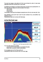
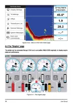
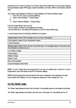
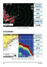
Summary of Contents for Pro Line FF-901

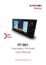
Page 1: ... Pro Li e FF 901 ALPH TReN Marine Chart plotterI Fish finder User Manual aIphatronmarine com ...

Page 2: ......

Page 3: ...aboxes customization 18 9 4 Tracks 43 5 Mapa Using C Map 4D 9 4 1 Editing track s color name and C Map Max and Navionics 19 description 43 5 1 Moving around the map 19 9 4 2 Setting up a track generation 5 2 Finding your boat position 19 interval and color logic 43 5 3 Chart Info and Quick Info 20 9 4 3 Converting track to route 44 5 4 Overzoom 21 9 5 Boundaries 44 6 Quick Settings 22 9 5 1 Creati...

Page 4: ...rge information 69 20 The Fish Finder 71 20 1 Switching on the Fish Finder 71 20 2 Tho Fish Finder lull page 71 20 3 Echogram history 72 20 4 Frequency 73 20 5 Display mode and settings 74 20 6 Offset 75 21 The Radar 77 21 1 Radar Compatibility and Functionality 77 21 2 Switching on the Radar 77 21 3 The Radar full page 77 21 4 Radar page settings 78 21 5 Radar echogram and settings 79 21 6 Radar ...

Page 5: ...ayed on the screen are enclosed in quotes The words press release mean operation with hardware keys located on plotters The words tap swipe mean operation with menu items buttons lists icons on touchscreen plotter The word select means choosing an item in two ways 1 using ajoystick joypad ora rotorwheel to highlight an item and ENTER key to select it 2 using tap gestures fortouchscreen plotters 1 ...

Page 6: ...ay also refer to BACK or CLR 1 3 Touchscreen gestures Tap touch the screen for less than 1 second and release your finger Perform action corresponding to touch area of the screen select activate button etc Long tap touch the screen and hold your finger for more than 1 second Open editable item e g databox 0 Pan touch the screen on the Map page keep your finger pressed and move in any direction Pan...

Page 7: ...able or disable the switcher Otherwise the tap gesture directly on the desired item switches between enabled and disabled states Sliders Sliders help to select and change numeric settings Values can be changed using the slider itself or by opening the virtual keyboard to enter the value manually Using the hardware keys 1 Use the joystick to target the slider 2 Press ENTER to activate the slider kn...

Page 8: ...ind a page by number 5 Press CLEAR or tap the Home icon to close the manual How to search a keyword 8 1 Press MENU to highlight the Search icon and ENTER to call a virtual keyboard or tap the Search icon 2 Type a keyword in the keyboard use UP DOWN and LEFT RIGHT to highlight a letter and ENTER to confirm selection or tap the letters After entering the keyword move the cursor over Done and press E...

Page 9: ... the preferred item by pressing DOWN I UP or tap with your finger It is possible to keep the default value 3 Press ENTER ortap to confirm the selection 4 Press CLEAR tap Back icon of the submenu ortap outside the submenu to return to Initial Settings items list 5 After introducing all desired changes select Confirm 6 On the Warning LIMITATIONSON USE page press DOWN orscroiiiD read the limitations ...

Page 10: ...option for each set ofunits To change lime zooe 1 Open the main menu by pressing MENU 2 Select General Settings Date and Time 3 Choose between UTC or Custom can be adjusted after UTC set to OFF Ifyou chose Custcm 1 Select the desired zone from the Custom submenu 2 Select Daylight Saving lime it must be enabled disabled manually To change date and time format 1 Open the main menu by pressing MENU 2...

Page 11: ...g pages on the touchscreen plotisrs can be dona also by vertical swipe from the top to call a page widget Aquickerway to switch between pages is to set one ofthe function keys Par 7 2 to Page Aswell some modelsofplottercan also have a PAGE keyforswitching pages 4 1 Status bar The status barappears in the upper left part of the screen on every page Itcan display verious icons WiFi connection status...

Page 12: ...752 NM Figure 4 2 a Map page kn ft 12 52 The Map page includes map cursorbox dalabcxes map modeswitch icon andwheel mode switch icon Quick Settings 83 Page kn Search Routes V Tracks Marks Boundaries Figure 4 2 b Map page menu 12 UserManual ...

Page 13: ...can be changed by tapping the Icon orfrom the main menu Par 16 3 Press ENTER or long tap the map to open the cursor contextual menu and CLEAR or tap elsewhere to close it Press MENU to open the main menu ofthe Map page 4 3 The Fish Finder page Figure 4 3 a Fish Finderpage simulation mode The Fish Finder page can be available If a Black Box Fish Finder accessory Is connected to the plotter Without ...

Page 14: ...tivity Figure 4 3 b Menu on the Fish Finderpage 4 4 The Engine page _o kn The plottercan be connected through CAN bus to compatible NMEA2000 englne s to display engine state and performance 14 l l 4 1 3 x1000 5 6 7 R 7500 s Il f I 11 3 x1000 5 6 7 RP 7500 s Figure 4 4 The Engine page UserManual ...

Page 15: ...te or dismissed Over heated in case of Over Temperature alarm Low Oil Pressure Engine AIann Level 2 Touch the bar to mute the alarm The message stays on the screen until the notification condition is over Low Battery Voltage Check Engine Battery Charge Water In Fuel Rev Limit Exceeded Engine Emergency Stop Mode NOTE A Level 1 Engine Alarm can be ignored but not mute An audible alarm is active for ...

Page 16: ...Figure 4 5 The Radarpage 4 6 The split pages A 41 48 5679 N V 6 54 5141 E 182 4 I 89 833 NM 1 Figure 4 6 a Example ofthe split Map I Fish Finderpage 16 _o UserManual ...

Page 17: ...always the Map part In order to operate on the Fish Finder or Radar part press MENU twice or tap the needed part of the page To open the contextual menu on the Map part press ENTER or long tap while the map view is active To open the contextual menu on the Fish Finder or Radar part press ENTER or long tap on the echogram Figure 4 6 b Example ofthe split MapI Radarpage UserManual 17 ...

Page 18: ... disable data boxes and customize the number of columns and databoxes content To customize databoxes content on Map Fish Finder or Radar pages 18 1 Long tap the databoxes 2 or 3 Open the main menu by pressing MENU and select Quick Settings Databoxes 4 Enable UseAdditional Column to display two columns ofdataboxes 5 Select the databox from main and additional column and choose the preferred option ...

Page 19: ...ode isactive now zoom rotata ortilt To change the modeon the touchscteen plotter tap wtleel modeswitch icontochooae thepreferred mode Depending on the plotter touchscreen gesturesor keyboard can be used to movearound the map Zoom mode Usejoystickorpan gestureto pan the map Use ZOOM IN and ZOOM OUl rctor wtleel or pinch in and pinch out gestures to change the map scale so that a smaller orlargerare...

Page 20: ...account your course to locate the boat at the most comfortable position on the map relative to the actual course To tum screen amplifier on off 1 Open the main menu by pressing MENU 2 Select General Settings Ship 3 Enable disable Own Ship Offset option Use the joystick or tap gesture to move the cursor away from the boars current position and exit the home mode The Back to FixAfter Timeout functio...

Page 21: ...s present on this page The Chart Info page contains Locate on Map and Go To buttons 5 4 Overzoom This option is available only with C Map MAX and 4D Maps If you want to overzoom the map in areas without the detailed coverage you can enable the overzoom mode This will allow you to zoom in to your user data closer This feature may be useful ifyou need to navigate to a user point for example mark or ...

Page 22: ...hart layertype depending on the cartography vector shaded relief satellite or rasterchart 22 types can be available Enable or disable VAD contour lines displaying on map Hide orshow latitude and longitude grid AIS and DSC displaying Enable or disable user data tracks routes marks and boundaries drawing on map Par 9 Hide orshow radar Hide orshow radar ring Chart Tooltlp opUon enables or disables th...

Page 23: ... the Map page includes the following settings Map mode Par 16 3 Wheel control function setting Par 5 1 Chart mode Par 1 3 AIS and DSC targets displaying Enable ordisable userdata tracks routes mart s boundaries drawing on map Par 9 Hide orshow radar Hide orshow radar rings Chart Tooltip option enables ordisables quick info box for map objects Set up databoxes Par 4 7 Enable MOB Par 13 Find a place...

Page 24: ...Wheel Control Zoom Chart Mode 2D Mode AIS DSC Targets Show Own Tracks Show Routes Show Marks Figure 6 2 a QuickSettings menu on the Map page with Navionics 24 User Manual ...

Page 25: ...K to dose the popup Thefile with yourplottersettingsconflguraUon fileextension Is lnl Islocated atthe rootfolderofmicro SO caret You can save it and import backto the plotteratany time 1 Insert micro SO card with a configuration file into the plotter 2 Open the main menu by pressing MENU 3 Select General Settings Restore and Backup Import Configuration By importing CXlnfigunrlionsfrom mian SD card...

Page 26: ...ocus helps to place the cursor to the user or the cartography objects on the map If it is enabled the target will be moved to the object when the cursor is placed near it Keyboard backlight Keyboard backlight can be set to auto custom or turned off 1 Open the main menu by pressing MENU 2 Select General Settings Keyboard and Input 3 In the Backlight section Select Off Auto or Custom 4 In case of Cu...

Page 27: ...tes and Navigation pages you can configure 1he following settings for navigation Automatic route following Par 8 3 Route following optimization Par 8 3 2 Cyclic Route Following This setting the continuous and cyclical following of a given route After following the entire route and when the vessel reaches the last waypoint navigation is directed back to 1he starting point of 1he same route and proc...

Page 28: ...ata received from antenna You can enable or disable position and speed filters 1 Open the main menu by pressing MENU 2 Select General Settings Navigation 3 Choose Position Filter or Speed Filter and select a type low medium or high or tum it off 7 4 Display settings Display settings allow adjustment of resolution and ratio of the screen connected to the plotter automatically or manually and to set...

Page 29: ... the ship icon displaying on map can be edited on the Ship page 1 Open the main menu by pressing MENU 2 Select General Settings Ship You can enable or disable heading and course lines drawing using Show COG Vector and Show Heading Line switchers these settings can also be changed in ship icon contextual menu on the Map page Own Ship Icon menu item allows you choosing your boat s icon on the map Sh...

Page 30: ...In the case of Navionics the Autorouting menu option will be available Underthese respective setting menus you may set preferred parameters for assisted routing See section 8 4 of this user manual for instructions on generating routes with Easy Routing and Autorouting as well as using their settings 7 81nternal GPS settings You can enable or disable SBAS setting on your plotter Enabled mode suppor...

Page 31: ...rack distance corridor lines are shown on the screen connecting the destination with the initial boars position departure point All navigation data in the data window such as BRG TTG DST XTE is related to the destination Whenyourvessel arrivesatthe destination crosses arrival circle radius a dialogwindow Destination reached appears on the screen To stop navlgaUon 1 Place the cursor at any place on...

Page 32: ...anu New you are in a routs creation mode 3 Move the cursorto the desired place on the map 4 Press ENTER or tap the map to add a waypoint or CLEAR to exit route creation mode When you create a new route it has defaultprefix Route with incrementing number You can change default prefix 1 Open the main menu by pressing MENU 2 Select Routes More Default Prefix 3 Create a new default prefix using the ke...

Page 33: ... the route beginning from the nearestwaypolnt or 4 Select Start Here to start navigating to the route beginning from this particular waypolnt or 5 Select Reverse to start route navigation from this point to the beginning of the route in reverse direction or 6 Select Go To to start navigating to the single destination and nat to route When you reach the firstwaypoint navigation will be started to t...

Page 34: ...one in route 1 Place the cursor at the waypoint which is a current destination 2 Call a contextual menu by pressing ENTER or a long tap 3 Select Skip Opening the waypolnts list To quickly access the list of all waypoints of a route and getdetailed information about it 1 Place the cursor over the waypoint on the map 2 Call a contextual menu by pressing ENTER or a long tap 3 Select Open WP Lisr Dele...

Page 35: ...Navionics detailed charts assisted routing functionality will be available In the case ofC Map 40 in use Easy Routing will be available In the case ofNavionics Aulorouling will be available 8 4 1 C Map Easy Routing To generate a recommended route with Easy Routing 1 Place the cursor at the desired start position 2 Call a contextual menu by pressing ENTER or tap the screen 3 Select Easy Routing and...

Page 36: ...pply this option 1 Place the cursor on a route leg a line that connects two waypoints 2 Call a contextual menu by pressing ENTER or a long tap 3 Select Leg Easy Routing NOTE You must have an up to date C Map 40 map to use Easy Routing This option is not supported by C Map MAX maps Navionics maps offer Autorouting Please make sure that your route is within detailed chart coverage NOTE See section 7...

Page 37: ...to permitAutorouting more time to calculate routes Based on these settings the recommended route will be created respecting them in comparison to information and obstacles on the detailed Navionics map Single Leg Autorouting You can also apply these settings to an existing route and Autorouting will modify the existing route leg accordingly The plotter will identify obstacles between two waypoints...

Page 38: ...ssible vie contextual manu When you press ENTER on the map or execute long tap gesture the contextual menu appears Using contextual menu you can add edit ordelate userdata 9 1 Marks Marksare a useful and easywayto markand store any placeon the map Ukeanyotheruserdata type marks can be added modified ordeleted both on the Marta page and on the map Marks 7 30000 Filter By I HideAII I mDelete All IMo...

Page 39: ...t using CLEAR 3 Call a contextual menu by pressing ENTER or a long tap 4 Select save Evenr 9 1 2 Editing marit s color symbol name and description _o You can change color symbol name and desaiption ofeach mark To edit marks on the Marks page 1 Open the main menu by pressing MENU 2 Select Marks 3 Choose a mark in the list 4 Select Color Symbol Name or Description On the Map page 1 Place the cursor ...

Page 40: ... See Par 9 7 on how to change a prefix Mark s number presentation can be set in the Marks settings 1 Open the main menu by pressing MENU 2 Select General Settings Marks Zero Handling 3 Choose Suppress to remove zeros in the mark s name e g Mark1 or Padding to see the full name e g Mark00001 Sometimes it may be useful to hide mark s name on the map 1 Open the main menu by pressing MENU 2 Select Gen...

Page 41: ... waypoint should be saved confirm by pressing ENTER ortap the map 5 Repeat previous step for each waypolnt 6 After all the waypoints are placed press CLEAR or tap Save butlan to exit route creation mode 9 2 2 Editing route s nama and description To edit route s name and desaiption on the Routes page 1 Open the main menu by pressing MENU 2 Select Routes 3 Choose a route in the list 4 Selact Name or...

Page 42: ...olnts can be accessed etlher from the map or from the Routes page 9 3 1 Editing waxpoinfs position Tochange waypolnt s coordinates In waypolnts list 1 Open the main menu by pressing MENU 2 Select Routes and choose a route from the list Detail 3 Selectthe waypoint in the list ofwaypoints Position 4 Input new latitude and longitude values and select Done to save or press CLEAR or tap Back icon to ex...

Page 43: ...AR ortap Back to Fix icon to center on fix position 2 Press ENTER to call a contextual menu 3 Enable Record Track You can also usefunction keys to start stop1rackrecording 9 4 1 Editing track s color name and description Youcan changecolor name and description oftracks Toadlvate theediting mode onthe Tracks page 1 Open the main menu by pressing MENU 2 Select Tracks 3 Choose a track in the list sel...

Page 44: ... selectthe tnK kgeneration interval 1 Open the main menu by pressing MENU 2 Open General Settings Tracks 3 Select Record By and choose the desired algorithm 4 In case Time or Dis1anoe were selectud set Time Interval or Distance Interval values 9A 3 Converting track to route You can converta track to a rou1s sothatthe newroute will outlinethe boarslnlck 1 Open the main menu by pressing MENU 2 Selec...

Page 45: ...to exit boundary creation mode or tap save button 9 5 2 Editing boundary s color name and description 1 Opan the main menu by pressing MENU 2 Select Boundaries 3 Choose a boundary in the list 4 Select Color Name cr Description To edit boundary scoloron the map 1 Place the cursor over the boundary 2 Call a contextual menu by pressing ENTER ora long tap 3 Select Edit Color Boundary0002 A Name BRG DS...

Page 46: ...x position on the Boundaries page 1 Open the main menu by pressing MENU 2 Select Boundaries and choose a boundary from the list Detail 3 Select the vertex in the list Position 4 Input new latitude and longitude values and select Done to save or press CLEAR or tap Back icon to exit position editing 9 6 Locate user data on the map You can browse through the listof all user poin1s ex marks and then o...

Page 47: ...ay user data on the map again To hide show a particular mark track route orboundary 1 Open the main menu by pressing MENU 2 Select Marks Tracks Routes or Boundaries page 3 Select the itemto hideorshow pressENTERtoopen the menuand select Hide or Show 9 9 User data filters You can filter routes by name and date tracks and boundaries by color name and date and filter marks by color symbol and name Ch...

Page 48: ...D card To export user data in DB format 1 Insert a micro SD card to the micro SD slot of the plotter 2 Open the main menu by pressing MENU 3 Select General Settings Restore and Backup Export User Data NOTE Do not eject the micro SD card until the message Data exported appears on your screen You do not need to switch off the plotter you can remove the micro SD even ifthe plotter is turned on To imp...

Page 49: ...ta 9 12 Deleting user data There are two ways to delete user data you can clear all the data at once or delete user points one by one To clear all the routes tracks marks and boundaries at once 1 Open the main menu by pressing MENU 2 Select General Settings Restore and Backup 3 Choose Clear User Data and confirm the action by selecting Yes User data can be deleted also on the Map page 1 Place the ...

Page 50: ... 10 A 8 frmdion In caseyouwant tc measure a distance bearingfromyourboattcone pointon lha map 1 Centerthe map on fix by pressing CLEAR ortap Backto Fix Icon 2 Calla contextual menu by pressing ENTER 3 Select A B The A pointwill be placed on a ship position 4 Move the cursor to the desired position on the map 5 Press ENTER ortap to save A B coordinates on the map or 6 Press CLEAR to exitA a mode To...

Page 51: ... MENU 2 Select Search 3 Choose the object to search and the range You can search different objects Ports Nearto Me Ports by Name and Service Tide Stations Current Stations Mart s Points of Interest Wrecks ObstrucUons Lakes Nearto Me by Name and Service Thesearchoperation maytakesometime depending onthespecified rangeofsearch The largerrange is covered by search the longer ittakesto find the object...

Page 52: ...h or 5 Select the tide station on the map 6 Call a contextual menu by pressing ENTER or a long tap 7 Select Show Graph Figure 12 a Tide height8lld tide streamstations on the Map page kn 01 06 On the Tide Station page you can see the Information about the tide levels and sunrise sunset and moonrise moonset time for the selected date To change the date on the Tide Station page 1 Select Set Data In t...

Page 53: ...he tide graph to see the tide height changes Press UP In orderto move the cursor backto 1t1e Change option ortap the top bar Press CLEAR ortap the Home icon on the top right ofthe screen to exitthe Tide station page NOTE On touchscreen plotters you can use two fingers swipe gesture to see tide graphs of previous or next days UserManual 53 ...

Page 54: ... be avalabl The MOB fiJncUon cen be e ccmectrrwnanypage by p MOB key orthe l loUM Alllo MOB c an be placed from Quick Settings menu n MOB Icon aplaCed etthe current 1lxIIO IItfon and etthe 881 Ume n lltgeUon IDINardathe MOB position 818118 To del8 MOB lccm and stop ll81ll9atiOnto H 1 Place cumoroverthe MOB Icon and rx Entar ortapthe Icon 2 Select Cancel MOB 54 ...

Page 55: ...fic amount of time for a beep to sound After the preset time will pass notification will continue to be displayed NOTE You can check alann settings using TestAiann action Navigation alarms Navigation alanns are presented with the following alanns Grounding alann scans map area within 1 nautical mile range in front of your course line plus 8 degrees to the left and 8 degrees to the right direction ...

Page 56: ...m occurs when the current tank value exceeds the notification percentage Wind alarms Wind alarms aimed to inform about wind speed or angle changes They include MaxlWSAlarm is triggered when wind speed exceeds the value set with MaxlWSValue slider Wind Shift Alarm is triggered when wind direction changes for more than 90 degrees during one second LowAWAAlarm is triggered when apparent wind angle va...

Page 57: ...h other a negative TCPA value will result as the minimum distance between vessels has been in the past Thus TCPAand CPA values will NOT display on the AIS page and no alarms will activate NOTE It may be preferable to tum CPA and TCPA alarms off or set their values to the minimum acceptable when approaching harbor entrances and rivers where there are many vessels and so AIS targets otherwise they m...

Page 58: ...and enable GPS Simulation 3 Select SOG and COG input the desired values To center fix icon on the map 1 Open the Map page 2 Press CLEAR to get to the home mode fix position will be centered or tap Back to Fix icon Figure 15 Simulation mode _o You can tum onAIS route following and Fish Findersimulation in the same way 58 Simulate Route Following option allows demonstrating automatic route following...

Page 59: ...r page 3 Switch ON the simulated radar by tapping on the TX I stand icon displayed on the top right of the screen or 4 Press Menu select Radar Configuration 5 Enable Radar Transmit Mode NOTE Most radar settings will not effect radar picture in radar simulation mode User Manual 59 ...

Page 60: ... General Settings Ship 3 Select COG Vector lime 4 Choose the desired value Now the course line will be finite and its length will depend on your boat s speed The end ofthe finite course line is indicated by the blue circle 16 2 Heading line The heading line is a line that starts from the boat s bow and indicates the heading direction It is presented on the map with an infinite green solid line by ...

Page 61: ...d up or course up otherwise you can choose a fixed custom map orientation rotating the map Par 5 1 1 Open the main menu by pressing MENU 2 Select Quick Settings Mode 3 Select the desired option among North Up Head Up or Course Up On touchscreen plotters you can also change the mode by tap on the mode icon on the top right of the screen UserManual 61 ...

Page 62: ...rnal GPS 5 Select the option for serial port from the list displayed below Serial ports can be set up to receive NMEA0183 data by selecting one ofthe following options NMEA 0183 device 1 Open the main menu by pressing MENU 2 Select Ports and Connectivity and select a port 3 Select the serial port with NMEA 0183 1abel 4 In the Baud Rate section select the desired baud rate Auto detect Connect NMEA ...

Page 63: ... 3 Select NMEA 0183 Output Options Enable Outpur On the Output Options page you can select the NMEA0183 version 2 0 3 0 4 0 or4 1 the NMEA0183 sentences for output For CAN port the port output function is available in the NMEA 2000 mode 1 Open the main menu by pressing MENU 2 Select Ports and Connectivity CAN Port Output Options 3 Select Enable Output to enable or disable output 4 Select the desir...

Page 64: ...n amount of seconds will be used for calculations The higher the damping is the steadier COG SOG and wind values are Which also means that they become less responsive to changes To set the damping time 1 Open the main menu by pressing MENU 2 Select Ports and Connectivity Offset 3 Set the desired values for Wind Damping and COG SOG Damping Boat position offset Sometimes the position of your boat ca...

Page 65: ...Cloud allows to use and manage it on any other plotter PC tablet or smartphone connecled to your privale doud In order to use Captain Cloud you need to create your account on captaindoud com then you need to login to Captain Cloud on the plotterwith the same credentials used on captaincloud com 1 Open the main menu by pressing MENU 2 Select General Settings Captain Cloud 3 Enter the email address ...

Page 66: ...nectthe plottertoa hotspot 4 Makesureyourtabletis connected tothesame hotspot 5 Open Portsand Connectivity Mirroreontrorand enable Onlinestatus The menu Icon will appear in thetop leftcomerofthe map page 8 Open your app and pair it to a plotter by inserting IPAddress which is displayed on the MirrorControl page 10 17 Figure 18 2 Menu icon on the Map page 18 3 Radar Wireless LAN connection compatib...

Page 67: ...Sailings Figure 19 1 a AIS target on the map The display fillerincludes thefollowing settings 1 AISTargets IDs display by defaultthis option is disabled 2 AI Targets INames display by defaultthis option is enabled AIS Targets Range Flltars 51 43 3260 N 3 40 4530 E T kn T 45 0 17 47 Bydefaul the infonna1ion isdisplayed forall targetswithin the display range of20 Nm TheAIS Targets Range Is the range...

Page 68: ...d value for ignoring and removing from display targets when they are moving slowerthan the speed you indicate To applyAIS targetspeed filter 1 Open the main menu by pressing MENU 2 Select General Settings AIS 3 Set1hedesired speed with Ignore Targets SlowerThan slider You will not seeAIS targets withthe speed slowerthan 1heselected value othersettings SARTTest option Enabling the SART Test option ...

Page 69: ...l Settings DSC 3 Select oscUst and choose the needed value 19 2 AIS and DSC target Information On the AIS pageyou can access1hefollowif l l information abouteach target Name DSTJBRG Call Sign Type CPAITCPA Position _A 49 40 81 74 N V z o4 7968 W A s r 1 s 9NM 1 1 Figure 19 2 a AIS targ t info box On the DSC page the following information isdisplayed MMSI Position Time DSTJBRG UserManual kn 69 ...

Page 70: ...get in the list ofAIS or DSCtargets By placing the cursor over an AIS target icon on the map the following information is displayed AIS name MMSI CPAand TCPA COG SOG and HOG see Fig 19 2 a DSC info boxshows MMSI date and time distance and bearing see Fig 19 2 b You can enable ordisablethe displayofAIStarget IDa and names on 1hemap 1 Open the main menu by pressing MENU 2 Select General Settings AIS...

Page 71: ...is option or Auto option of the serial port or there may be a special port to connect the external Fish Finder device A Fish Finder icon E J appears in the status bar after Fish Finder is connected and detected by the plotter Disconnected label appears at the bottom ofthe Fish Finder page in case you have disconnected the Fish Finder NOTE The plotter does not support more than one Fish Finder so m...

Page 72: ...tory 8 Databoxes Par 4 7 9 Cursor box reporting time and depth data corresponding to the Intersection of VDM and vertical time marker lines In orderto hidethe curser press CLEAR Fish Finder main menu Press MENU on Fish Finder page to make adjustments of Frequency Display mode Display settings Transmission settings Offset Transducar list The restofthe menu Items are common for all the pages General...

Page 73: ...red position 2 Call1tle contextual menu by pressing ENTER or by a long tap gestura 3 Select Save Mark The mam is placed and saved in the place where your boatwas located at that exacttime moment To start navigation to the point 1 Press LEFT I RIGHT to place the vertical time malt erortap in the desired position to place the cursor 2 Call1tle contextual menu by pressing ENTER or by a long tap gestu...

Page 74: ...des Display setllngs alow you tc change color schemes display mode and tuning the Gain mode Noise FIIBr and SensitiviV You can find displaymodeandsettings inthemain menuofthe FIBh Finder page Display mode Display modes can differ depending on a transducer Single mode displays full Fish Finder page with a single echogram for the selected frequency Dual mode if supported by the transducer splits the...

Page 75: ... located near the surface so it is useful to enable Surface Noise Filter Depending on the transmission line ofa transducar you can increase ordecrease Area Noise Filter values Sensitivity Interference setting allows reducing the influence ofotherFish Finden orequipmentthatcan appear on the screen You can set Erase Weak Echos value so that reflections from plankton orsediments will notappearon thee...

Page 76: ...sensor Using the readings from a precise temperature measuring device you can insert a positive negative offset to display the correct value on the Fish Finder screen Speed calibrates the value of water speed sensor The calibration value in the range between 50 and 50 will be applied to the water speed from the transducer 76 User Manual ...

Page 77: ...e WiFi radar antenna should be provided with your antenna If not please refer to manufacturer information or your reseller I installer Radar and otherWIFI connections to your plotter You may have only one active WiFi connection at a time with your plotter Connecting to a WiFi radar antenna will automatically interrupt any all other connections such as Internet connection or Mirror Control App from...

Page 78: ... is a white dashed bearing line that can be used to measure the bearing to a target See Par 21 5 on how to edit EBL and VRM The Radar main menu Press MENU on the Radar page to make adjustments of Quick Settings Radar Color Schemes Radar Tuning Radar Configuration The rest ofthe menu items are the same as the standard Map page Marks AIS DSC Alarms General Settings System Messages Ports and Connecti...

Page 79: ...reen echogram in nightmode 21 5 Radar echogram and settings After the Radarisconnected and configured ID preference the echogram displays on the Radar page The echogram displays the information aboutthe location ofobjects around the vassal and you can zoom In to see the closest objects orzoom out to see full picture You can place a mark or an event in anywhere on the echogram display page 1 Press ...

Page 80: ...Call the contextual menu by pressing ENTER or by a long tap gesture 3 Enable the Zoom Mode switcher Zoom Mode 16 59 Figure 21 5 a Cursorcontextual menu Guard zone You can enable guard zones on the Radar page and set a notification for each one To enable guard zones display 1 Open the main menu by pressing MENU on the Radar page 2 Select Quick Settings 3 Enable Guard ZOne 1 and I or Guard ZOne 2 Gu...

Page 81: ... in case a target is exists or is outside the zone 4 In case you no longer want to receive notifications repeat the steps and select Off 15 51 21 5 b Guardzone editmode 21 6 Radar tuning Most ofthe menu items of RadarTuning become available after an antenna is connected Please keep in mind that resetting the plotter to factory defaults will not affect these radar settings as they are stored in the...

Page 82: ...clutter whereas excessively high settings will result in targets being removed with the clutter For optimal sea clutter control seek a compromise setting whereby minimal sea clutter remains visible to windward but targets are sufficiently distinct For optimal rain duttercontrol seek a compromise setting whereby air precipitation clutter remain visible in the area of weather but again targets are d...

Page 83: ...u by pressing MENU on the Radar page 2 Select Radar Tuning Tune Mode 3 Set Tune Mode to Auto or 4 Set Tune Mode to Manual and select Manual Tune value 21 7 Radar configuration TuneMdeo adjustment Tune video adjustment is run after antenna installation or service To perform tune video adjustment 1 Open the main menu by pressing MENU on the Radar page 2 Select Radar Configuration TuneNideo Adjustmen...

Page 84: ...the dead sector 1 Open the main menu by pressing MENU on the Radar page 2 Select Radar Configuration Dead Sector 3 Enable Dead Sector the sliders below will be no longer disabled 4 Set the starting angle related to the heading and the size of the sector Noise reJection Electrical noise can be eliminated by turning on the noise rejection option 1 Open the main menu by pressing MENU 2 Select Radar C...

Page 85: ...e is is scaled and drawn directly on the chart data This display mode Is particularly useful to compare chart and radar data helping to beHer distinguish land and other fixed objects especially in low visibility conditions and to more easily identify and distinguish targets in the surrounding area To enable the radar overlay 1 Open the Map page 2 Press MENU Quick Settings 3 Enable Show Radar swttc...

Page 86: ...ng MENU 2 Select system Messages System messages can betittered by message type using Show byType menu choose All Notifications or System by data choosing From and To date To save a specificsystem message orall system messageson the micro SO card 1 Insert the micro so card into the plotter 2 Open the main menu by pressing MENU 3 Select System Messages 4 Choose asystem message and confirm the actio...

Page 87: ...date package You may update software immediately or any time later NOTE You will need to restart plotter in order to apply the software update If you decide to update later you need to select Later in the software update dialog When you decide to apply software update restart the system to get software update dialog again and select Download You can check the downloading status 1 Open the main men...

Page 88: ...r Ground Direction of the path over ground actually followed by a vessel Course Line Time Line Graphical indication ofthe direction in which the Vessel is heading The Course Line origin is the vessel s position so the time line movement is synchronized with the vessels Icon Course Line Course is given by the value of COG Course Over Ground and its length is proportional to the SOG Speed Over Groun...

Page 89: ...so COG HOOP Horizontal Dilution Of Precision Precision ofthe positioning system GPS The smaller HOOP value indicates higher position accurately Home mode All operations referto the vessel s position Landmark8 Landmarks are any prominent object such as monument building silo tower mast etc on land which can be used in determining a location or a direction Lat Lon Coordinate system using Latitude an...

Page 90: ...formation about the accuracy integrity continuity and availability of its signals Scale Allows the display of Map Scale magnitude ofthe reference scale expressed in the actual unit of measure and the current Map Dab im SNR Signal to Noise R tio Ratio between the magnitude ofa radio signal and the magnitude ofthe noise that is the interferences The SRN is expressed in decibels and it is associated ...

Page 91: ... on the prasent location ofyourboat The point of intersection is the target ofthe VRM and the EBL Also see EBL WAAS WideArea Augmentation Syslam The FederalAviation Administration FAA in cooperation with other DOT organizations and DOD is augmenting the GPS SPS with asatellite basad augmentation system the WAAS Itwill provide a signal ii Hipace to WAAS users to support en route through precision a...

Page 92: ... 9 A B 8 A B 10 Leg Eaay Routing C Map 40 Leg 10 Move Veaael Here1 9 Chartlnfc Autorouting Navionica 11 Calculata Fix orr m3 10 Calculata Fix orr m3 11 Edit Name 12 Edit Deacription 13 Delela Route 14 Open WP Liat Route leg during navlgaHon Route leg during navlgaHon Routa WP no navlgaHon Adlve route Notcurrant lag Acltva roulle currant leg 1 Start Hera 1 Stop Nav 1 stopNav 2 Rawree 2 Raalart Nav ...

Page 93: ...ditA 6 5 Dele A a 8 ChartInfo 7 CalculaiB FD Oll llef T ckin navigation 1 Slop NIIY 2 GoTo 3 SaveMerk 4 N Rcul8 5 Easy Routing c Map 4DYAutorouting Navionics 8 EditColor 7 Hid 8 DeleTI Bck 9 A B 10 Chart Info 11 MOB At tM nick no navVition 1 GoTo 2 SaveMark 3 N Rcul8 4 Easy Routing c Map 4DYAutorouting Navionics 5 EditColor 6 A B 7 ChartInfo 8 MOB Mar1 Ew ntno naYV tion 1 GoTo 2 Move To Vessel 3 M...

Page 94: ......

Page 95: ......

Page 96: ...and does not represent a commitment on the part ofAlphatron Marine B V The Netherlands T 3110 453 4000 Document name FF 901 Document nr 0100 Version V1 0 F 3110 453 4010 service jrc europe com www alphalronmarine com All rights reserved Alphatron Marine B V Centers ofExcellence Houston Rotterdam Singapore Tokyo 1111111111111111111111111111111111111111111111111 MAUMMAPO AE010 ...

Reviews: