

Summary of Contents for Earthmate GPS PN-60
Page 1: ...Earthmate PN 60 GPS DELORME User Manual ...
Page 5: ......
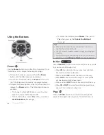
The DeLorme Earthmate GPS PN-60 is an advanced and reliable navigation device that provides accurate positioning and mapping features. Enhance your outdoor adventures with its intuitive interface and extensive functionality. Easily access the comprehensive user manual, available for free download at 88.208.23.73:8080, to maximize your experience with this exceptional device.
Page 1: ...Earthmate PN 60 GPS DELORME User Manual ...
Page 5: ......