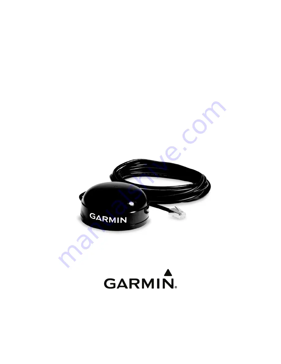
background image


GPS 16x 

TECHNICAL 

SPECIFICATIONS 


Garmin International, Inc. 

1200 E. 151

st

 Street 

Olathe, KS 66062 USA 


190-00228-08 Revision C 

October 2011 

Summary of Contents for 16X LVS

Page 1: ...GPS 16x TECHNICAL SPECIFICATIONS Garmin International Inc 1200 E 151st Street Olathe KS 66062 USA 190 00228 08 Revision C October 2011 ...

Page 2: ...ic storage medium to be viewed and to print one copy of this manual or of any revision hereto provided that such electronic or printed copy of this manual must contain the complete text of this copyright notice and provided further that any unauthorized commercial distribution of this manual or any revision hereto is strictly prohibited Information in this document is subject to change without not...

Page 3: ... 2 GPS 16x Wiring and Pinouts 7 2 1 GPS 16x Pinout 7 2 2 GPS 16x Wiring Diagrams 8 3 Mechanical Characteristics Mounting 9 3 1 GPS 16x Flush Mount 9 3 2 GPS 16x Optional Magnetic Mount 10 4 Software Interface 11 4 1 Received NMEA 0183 Sentences 11 4 1 1 Almanac Information ALM 11 4 1 2 Sensor Initialization Information PGRMI 12 4 1 3 Sensor Configuration Information PGRMC 12 4 1 4 Additional Senso...

Page 4: ...Review 26 Ephemeris Download Procedure 27 TX Packet Ephemeris Data Request 27 RX Packet Acknowledgement 27 RX Packet Number of Data Packets to Expect 27 TX Packet Acknowledgement 27 RX Packet Ephemeris Data 28 TX Packet Download Complete 30 Appendix D Sensor Configuration Software 31 Downloading the Sensor Configuration Software 31 Selecting a Model 31 Connecting to the Sensor 31 Menus 32 File Men...

Page 5: ... to comply with the limits for a Class B digital device pursuant to part 15 of the FCC rules These limits are designed to provide reasonable protection against harmful interference in a residential installation This equipment generates uses and can radiate radio frequency energy and may cause harmful interference to radio communications if not installed and used in accordance with the instructions...

Page 6: ...LTING FROM THE USE MISUSE OR INABILITY TO USE THE PRODUCT OR FROM DEFECTS IN THE PRODUCT SOME STATES DO NOT ALLOW THE EXCLUSION OF INCIDENTAL OR CONSEQUENTIAL DAMAGES SO THE ABOVE LIMITATIONS MAY NOT APPLY TO YOU Garmin retains the exclusive right to repair or replace with a new or newly overhauled replacement product the device or software or offer a full refund of the purchase price at its sole ...

Page 7: ...clear view of the GPS satellites The system may communicate with the GPS via an asynchronous serial communications port Internal FLASH memory allows the GPS to retain critical data such as satellite orbital parameters last known position date and time End user interfaces such as keyboards and displays are the responsibility of the application designer 1 4 FEATURES GPS receiver tracks and uses mult...

Page 8: ...r 28 AWG with RJ 45 termination 1 5 1 4 Color GPS 16xLVS 16xHVS Black with white logos 1 5 1 5 Case Material Polycarbonate thermoplastic that is waterproof to IEC 60529 IPX7 level immersion in 1 meter of water for 30 minutes 1 5 2 Electrical Characteristics 1 5 2 1 Input Voltage GPS 16xLVS 3 3 Vdc to 6 0 Vdc regulated 100 mV ripple GPS 16xHVS 17HVS 8 0 Vdc to 40 Vdc unregulated 1 5 2 2 Input Curre...

Page 9: ...ility Dynamics 999 knots velocity only limited at altitude greater than 60 000 feet 3g dynamics 1 5 5 Interfaces True RS 232 output asynchronous serial input compatible with RS 232 or TTL voltage levels RS 232 polarity User selectable baud rate 4800 9600 19200 or 38400 1 5 5 1 Port 1 Configurable between NMEA 0183 Versions 2 00 factory default and 3 00 ASCII output sentences GPALM GPGGA GPGLL GPGS...

Page 10: ...190 00228 08 GPS 16x Technical Specifications Rev C Page 6 1 5 5 3 PPS 1 Hz pulse programmable width 1 µs accuracy 1 5 5 4 Power Control Off Open circuit On Ground or pull to low logic level 0 3 volts ...

Page 11: ...ge 25 Vdc 25 This input may also be directly connected to standard 3 to 5 Vdc CMOS logic The low signal voltage requirement is 0 6 V and the high signal voltage requirement is 2 4 Vdc Input impedance is between 3 0 and 7 0 kΩ This input may be used to receive serial initialization configuration data as specified in section 4 1 Received NMES 0183 Sentences 5 White PORT 1 DATA OUT First Serial Async...

Page 12: ...28 08 GPS 16x Technical Specifications Rev C Page 8 2 2 GPS 16x WIRING DIAGRAMS Figure 1 Computer Serial Port Interconnection Figure 2 PDA Serial Port Interconnection Figure 3 Basic NMEA Device Interconnection ...

Page 13: ...16x Technical Specifications Rev C Page 9 3 3 1 GPS 16x FLUSH MOUNT MECHANICAL CHARACTERISTICS MOUNTING Figure 4 GPS 16x Flush Mount Dimensions 1 65 inches 42 mm 3 58 inches 91 mm 2 44 inches 62 mm 120 Degrees M4 Thread ...

Page 14: ...190 00228 08 GPS 16x Technical Specifications Rev C Page 10 3 2 GPS 16x OPTIONAL MAGNETIC MOUNT Figure 5 Optional GPS 16x Magnetic Mount Magnetic Mount M4 Flat Head Screws 3 each ...

Page 15: ...configuration parameter All sentences received by the GPS sensor must be terminated with CR LF the ASCII characters for carriage return 0D hexadecimal and line feed 0A hexadecimal The checksum hh is used for parity checking data and is not required but is recommended for use in environments containing high electromagnetic noise It is generally not required in normal PC environments When used the p...

Page 16: ...alues Current default values can also be obtained by sending PGRMCE to the GPS sensor PGRMC 1 2 3 4 5 6 7 8 9 10 11 12 13 14 hh CR LF 1 Fix mode A Automatic 3 3D exclusively 2 Altitude above below mean sea level 1500 0 to 18000 0 meters 3 Earth datum index If the user datum index 96 is specified fields 4 through 8 must contain valid values Otherwise fields 4 through 8 must be null Refer to Appendi...

Page 17: ...nitialization Information PGRMI If the GPS sensor is in the Binary data mode it is necessary to send the following eight byte data stream to temporarily change the data format to NMEA 0183 Then follow by sending a PGRMC1 sentence that turns off the Binary Output Data format 10 0A 02 26 00 CE 10 03 Hexadecimal 4 1 5 Output Sentence Enable Disable PGRMO The PGRMO sentence provides the ability to ena...

Page 18: ...hnical Specifications Rev C Page 14 PGRMO G will cause the COM port to change to Garmin Data Transfer format for the duration of the power cycle You must enable Garmin Data Transfer format to update the GPS 16x series products ...

Page 19: ...mitted per second Sentence Output by Default Maximum Characters GPRMC 74 GPGGA 82 GPGSA 66 GPGSV 70 PGRME 35 GPGLL 44 GPVTG 42 PGRMV 32 PGRMF 82 PGRMB 40 PGRMID 82 PGRMM 32 PGRMT 50 Baud Table 2 NMEA 0183 Output Sentence Order and Size Characters per Second 4800 480 9600 960 19200 1920 38400 3840 The maximum number of fields allowed in a single sentence is 82 characters including delimiters Values...

Page 20: ...nd will be only 59 seconds long In this case the GPS sensor will not transmit the time of day 0h 0m 0s the zero second for the day from which the leap second is removed GPRMC 235959 A 3851 3650 N 09447 9373 W 000 0 000 0 111103 003 3 E 69 GPRMC 000001 A 3851 3650 N 09447 9373 W 000 0 000 0 121103 003 3 E 6A GPRMC 000002 A 3851 3650 N 09447 9373 W 000 0 000 0 121103 003 3 E 69 4 2 3 Global Position...

Page 21: ...ill be null if unused 4 2 7 Recommended Minimum Specific GPS TRANSIT Data RMC GPRMC 1 2 3 4 5 6 7 8 9 10 11 12 hh CR LF 1 UTC time of position fix hhmmss format 2 Status A Valid position V NAV receiver warning 3 Latitude ddmm mmmm format leading zeros will be transmitted 4 Latitude hemisphere N or S 5 Longitude dddmm mmmm format leading zeros will be transmitted 6 Longitude hemisphere E or W 7 Spe...

Page 22: ...ngitude dddmm mmmm format leading zeros will be transmitted 9 Longitude hemisphere E or W 10 Mode M Manual A Automatic 11 Fix type 0 no fix 1 2D fix 2 3D fix 12 Speed over ground 0 to 1851 kilometers hour 13 Course over ground 0 to 359 degrees true 14 Position dilution of precision 0 to 9 rounded to nearest integer value 15 Time dilution of precision 0 to 9 rounded to nearest integer value 4 2 12 ...

Page 23: ... this model and is included only for backwards compatibility 7 DGPS fix source R RTCM W WAAS N Non DGPS Fix 8 DGPS mode A Automatic W WAAS Only R RTCM Only N None DGPS disabled 4 3 BAUD RATE SELECTION Baud rate selection can be performed by sending the appropriate configuration sentence to the GPS sensor as described in the PGRMC section 4 1 3 Sensor Configuration Information PGRMC field 10 4 4 ON...

Page 24: ...ate and Erromango Islands 14 BERMUDA 1957 Bermuda Islands 15 BOGOTA OBSERVATORY Colombia 16 CAMPO INCHAUSPE Argentina 17 CANTON ASTRO 1966 Phoenix Islands 18 CAPE CANAVERAL Florida Bahama Islands 19 CAPE South Africa 20 CARTHAGE Tunisia 21 CHATHAM 1971 Chatham Island New Zealand 22 CHUA ASTRO Paraguay 23 CORREGO ALEGRE Brazil 24 DJAKARTA BATAVIA Sumatra Island Indonesia 25 DOS 1968 Gizo Island New...

Page 25: ...TH AMERICAN 1927 Bahamas excluding San Salvador Island 57 NORTH AMERICAN 1927 Central America Belize Costa Rica El Salvador Guatemala Honduras Nicaragua 58 NORTH AMERICAN 1927 Canal Zone 59 NORTH AMERICAN 1927 Canada including Newfoundland Island 60 NORTH AMERICAN 1927 Caribbean Barbados Caicos Islands Cuba Dominican Republic Grand Cayman Jamaica Leeward Islands Turks Islands 61 NORTH AMERICAN 192...

Page 26: ...South Chile 87 SANTO DOS Espirito Santo Island 88 SAO BRAZ Sao Miguel Santa Maria Islands Azores 89 SAPPER HILL 1943 East Falkland Island 90 SCHWARZECK Namibia 91 SOUTHEAST BASE Porto Santo and Madeira Islands 92 SOUTHWEST BASE Faial Graciosa Pico Sao Jorge and Terceira Islands Azores 93 TIMBALAI 1948 Brunei and East Malaysia Sarawak and Sabah 94 TOKYO Japan Korea Okinawa 95 TRISTAN ASTRO 1968 Tri...

Page 27: ...byte 10 hex and an end of transmission character 03 hex Note If RTCM 104 differential data is sent to the GPS sensor the board will reset the Garmin Binary Output Data baud rate to the same baud rate used for RTCM 104 data If the differential inputs are used on the GPS sensor the RTCM 104 data must be sent to the GPS sensor at 9600 baud preferred or 4800 baud RTCM 104 baud rates less than 4800 bau...

Page 28: ...ace vehicle identification 1 32 and 33 64 for WAAS uint16 snr signal to noise ratio uint8 elev satellite elevation in degrees uint16 azmth satellite azimuth in degrees uint8 status status bit field cpo_sat_data The status bit field represents a set of booleans described below Bit Meaning when bit is one 1 0 The unit has ephemeris data for the specified satellite 1 The unit has a differential corre...

Page 29: ...e and initialize static variables static char in_que 256 static int in_que_ptr 0 static rx_state_type rx_state DAT void add_to_que char data define DLE_BYTE 0x10 define ETX_BYTE 0x03 if rx_state DAT if data DLE_BYTE rx_state DLE else in_que in_que_ptr data else if rx_state DLE if data ETX_BYTE rx_state ETX else rx_state DAT in_que in_que_ptr data else if rx_state ETX if data DLE_BYTE rx_state DLE ...

Page 30: ...unit is in Garmin binary format transmitted and received packets are structured as follows Byte Description Name Notes Packet Delimiter DLE 0x10 Packet ID type ID Packet type Data Size SIZE Number of bytes in data portion not including escaped DLEs See below Data bytes DATA Not to exceed 256 bytes Checksum CHKSUM 2 s complement of the arithmetic sum of all the bytes from the Packet ID byte to the ...

Page 31: ... ID IOP_ACK_BYTE 0x06 Number of bytes in data SIZE 0x02 Request to D L ephemeris IOP_CMND_DATA 0x0A Pad DATA 0x00 Checksum calculation CHKSUM Delimiter DLE 0x10 End of packet ETX 0x03 Then the unit will immediately send a packet communicating how many data packets to expect for the ephemeris download a maximum of twelve RX Packet Number of Data Packets to Expect Byte Description Name HEX Value Del...

Page 32: ...meris data record for SPC sint16 wn week number weeks float toc reference time of clock parameters s float toe reference time of ephemeris parameters s float af0 clock correction coefficient group delay s float af1 clock correction coefficient s s float af2 clock correction coefficient s s s float ura user range accuracy m double e eccentricity double sqrta square root of semi major axis a m 1 2 d...

Page 33: ...Temp EphStruct af2 float m_TempArray IDX_EPH_AF2 pTemp EphStruct ura float m_TempArray IDX_EPH_URA cnvt_ieee_double long m_TempArray IDX_EPH_E pTemp EphStruct e double m_TempArray IDX_EPH_E cnvt_ieee_double long m_TempArray IDX_EPH_SQRTA pTemp EphStruct sqrta double m_TempArray IDX_EPH_SQRTA cnvt_ieee_double long m_TempArray IDX_EPH_DN pTemp EphStruct dn double m_TempArray IDX_EPH_DN cnvt_ieee_dou...

Page 34: ...H_M0 52 define IDX_EPH_W 60 define IDX_EPH_OMG0 68 define IDX_EPH_I0 76 define IDX_EPH_ODOT 84 define IDX_EPH_IDOT 88 define IDX_EPH_CUS 92 define IDX_EPH_CUC 96 define IDX_EPH_CIS 100 define IDX_EPH_CIC 104 define IDX_EPH_CRS 108 define IDX_EPH_CRC 112 define IDX_EPH_IOD 116 The last packet will be a download complete packet that will look like this TX Packet Download Complete Byte Description Na...

Page 35: ...ads SNSRCFG exe is included in the software update download Selecting a Model Double click SNSRCFG exe The Set Base Model to window appears Select the radio button next to the type of Garmin sensor you are configuring Connecting to the Sensor After selecting the type of sensor the following window opens This is the Main Interface Screen for the program To configure your sensor you must first conne...

Page 36: ... disconnect from the sensor Config Menu The Config Configuration Menu allows you to configure the sensor as it is connected Sensor Configuration F6 Opens the Sensor Configuration window shown to the right Many of the fields in this window should not be changed Refer to the beginning of this manual for information on many of these fields This window is used to enter a new latitude longitude and alt...

Page 37: ...og box You must locate both the rgn file and the updater exe file View Menu The View Menu allows you to view the NMEA sentences transmitted by the sensor You can also customize how the program looks by showing and hiding the Toolbar and Status Bar Help Menu The Help Menu displays the software version and copyright information For the latest free software updates excluding map data throughout the l...

Reviews: