background image

Piper

PA32

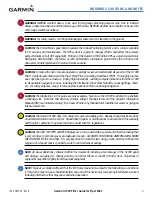
Summary of Contents for G1000:Piper

Page 1: ...Piper PA32...

Page 2: ...reproduced copied transmitted disseminated downloaded or stored in any storage medium for any purpose without the express written permission of Garmin Garmin hereby grants permission to download a sin...

Page 3: ...UNDER ANY WARRANTY OF MERCHANTABILITY OR FITNESS FOR A PARTICULAR PURPOSE STATUTORY OR OTHERWISE THIS WARRANTY GIVES YOU SPECIFIC LEGAL RIGHTS WHICH MAY VARY FROM STATE TO STATE IN NO EVENT SHALL GAR...

Page 4: ...r correlated information available in the cockpit WARNING The altitude calculated by G1000 GPS receivers is geometric height above Mean Sea Level and could vary signi cantly from the altitude displaye...

Page 5: ...repancies before continuing navigation CAUTION The illustrations in this guide are only examples Never use the G1000 to attempt to penetrate a thunderstorm Both the FAA Advisory Circular Subject Thund...

Page 6: ...dance with California s Proposition 65 If you have any questions or would like additional information please refer to our website at www garmin com prop65 NOTE WhenusingStormscope thereareseveralatmos...

Page 7: ...e for Piper PA32 v REVISION INFORMATION Record of Revisions Part Number Revision Date Page Range Description 190 00692 00 190 00692 00 190 00692 00 1 A B 1 15 07 3 15 07 4 4 07 i I 4 All All Initial r...

Page 8: ...Annunciations and Alerting Functions 2 25 G1000 Alerting System 2 25 Marker Beacon Annunciations 2 26 Traf c Annunciation 2 26 TAWS Annunciations 2 27 Altitude Alerting 2 27 Minimum Descent Altitude...

Page 9: ...B MFD 5 57 5 14 Nearest VOR MFD 5 58 5 15 Nearest User Waypoint MFD 5 59 5 16 Nearest Airspaces 5 61 5 17 Nearest Airports PFD 5 64 5 18 Flight Planning MFD 5 66 Airways Jetways 5 78 Display of Airway...

Page 10: ...rt Options 8 38 Day Night View 8 41 FliteCharts Cycle Number and Expiration Date 8 43 8 4 XM Radio Entertainment Optional 8 47 XM Satellite Radio Service 8 47 XM Service Activation 8 48 Using XM Radio...

Page 11: ...format displays The system consists of the following Line Replaceable Units LRUs GDU 1040 Primary Flight Display PFD GDU 1040 Multi Function Display MFD GIA 63W Integrated Avionics Unit IAU GDC 74A A...

Page 12: ...ncommunicationhub linkingallLRUswiththePFD EachGIA 63Wcontains a GPS receiver VHF COM NAV GS receivers a ight director FD and system integration microprocessors The GIA 63W also contains a GPS WAAS re...

Page 13: ...with the GDC 74A to obtain air data and with both GIAs to obtain GPS information AHRS modes of operation are discussed later in this document GMU 44 1 Measures local magnetic eld Data is sent to the...

Page 14: ...rmation to the G1000 MFD and indirectly to the inset map of the PFD as well as optional digital audio entertainment The GDL 69 69A communicates with the MFD via HSDB connection A subscription to the X...

Page 15: ...Avionics Unit System Integration Processors I O Processors VHF COM VHF NAV LOC GPS WAAS Glideslope GTX 33 Transponder High Speed Data Bus Ethernet Reversionary Control GEA 71 Engine Airframe Unit GDC...

Page 16: ...e Lightning Strike and Thunderstorm Detection optional Honeywell KR 87 ADF Receiver optional Honeywell KN 63 DME Transceiver optional GDL 69 69A Data Link Real time Weather Digital Audio Entertainment...

Page 17: ...e located on the PFD and MFD bezels and audio panel The controls for the PFD and MFD are discussed in the following pages of this section PFD MFD CONTROLS Figure 1 3 PFD MFD Controls 1 2 4 6 12 8 7 5...

Page 18: ...s 8 COM Frequency Transfer Key Transfers the standby and active COM frequencies Pressing and holding this key for two seconds automatically tunes the emergency frequency 121 5 MHz in the active freque...

Page 19: ...cts IFR departure procedures DPs arrival procedures STARs and approaches IAPs from the database and loads them into the active ight plan 16 ENT Key Accepts a menu selection or data entry This key is u...

Page 20: ...selected when the PA Key is pressed 10 SPKR Pressing this key selects and deselects the corresponding cockpit speaker Com and Nav receiver audio will be heard on the speaker 11 MKR MUTE Mutes the curr...

Page 21: ...to switch between volume and squelch control as indicated by the VOL or SQ being illuminated Turn to adjust intercom volume or squelch The MAN SQ Key must be selected to allow squelch adjustment 23 P...

Page 22: ...al SD cards and are located on the upper right side of the display bezels Each display bezel is equipped with two SD card slots SD cards are used for aviation database and system software updates as w...

Page 23: ...PFD the AHRS begins to initialize and displays AHRS ALIGN Keep Wings Level The AHRS should display valid attitude and heading elds typically within the rst minute of power up The AHRS can align itself...

Page 24: ...mation see the GPS Navigation Section while the left portion of the MFD is dedicated to the Engine Indication System EIS see the EIS Section Both displays offer control for COM and NAV frequency selec...

Page 25: ...t information NOTE Aggressive maneuvering while AHRS is not operating normally may degrade AHRS accuracy The Attitude and Heading Reference System AHRS performs attitude heading and vertical accelerat...

Page 26: ...time which would result in an extended period of time where valid AHRS outputs are unavailable Two GPS inputs are provided to the AHRS If GPS information from one of the inputs fails the AHRS uses the...

Page 27: ...min authorized repair facility Figure 1 12 G1000 System Failure Annunciations GDC 74A Air Data Computer GTX 33 Transponder OR GIA 63W Integrated Avionics Units GDC 74A Air Data Computer GEA 71 Engine...

Page 28: ...et Map TOPO Displays topographical data e g coastlines terrain rivers lakes and elevation scale on Inset Map TERRAIN Displays terrain information on Inset Map STRMSCP Displays Stormscope information o...

Page 29: ...elects Mode A transponder replies to interrogations ALT SelectsModeC altitudereportingmode transponderrepliestoidenti cation and altitude interrogations GND Allows manual selection of ground mode in c...

Page 30: ...ess the BACK or OFF Softkey to return to the top level softkeys ALERTS STRMSCP DME ALERTS Figure 16 PFD Con guration Softkeys Press the STD BARO or BACK Softkey to return to the top level softkeys BRG...

Page 31: ...reversionary mode All other critical ight data displays in the same format as in normal operating mode and is discussed in other sections of the System Overview ENGINE Displays the LEAN and SYSTEM So...

Page 32: ...SYSTEM CYL SLCT ALERTS ENGINE BACK LEAN SYSTEM DEC FUEL INC FUEL RST FUEL Press the ENGINE Softkey on this level to return to the previous page level Press the ENGINE Softkey on this level to return...

Page 33: ...ning to full MAP Enables second level Navigation Map softkeys TRAFFIC Displays traf c information on Navigation Map TOPO Displays topographical data e g coastlines terrain rivers lakes and elevation s...

Page 34: ...e BACK Softkey on this level to return to the top softkey level optional optional optional optional ENGINE MAP DCLTR SHW CHRT DCLTR 1 DCLTR 2 DCLTR 3 TRAFFIC TOPO TERRAIN AIRWAYS STRMSCP NEXRAD XM LTN...

Page 35: ...key selection does not display menus or submenus Navigating the Page Menu Window 1 Press the MENU Key to display the Page Menu Window 2 Turn the FMS Knob to scroll through a list of available options...

Page 36: ...con guration of optional equipment Selecting a page using the FMS Knob 1 Turn the large FMS Knob until the desired page group is selected 2 Turn the small FMS Knob until the desired page is selected...

Page 37: ...y Departure Information DP softkey Arrival Information STAR softkey Approach Information APR softkey Weather Information WX softkey Intersection Information NDB Information VOR Information User Waypoi...

Page 38: ...procedures PROC which are accessed by bezel key In some instances softkeys may be used to access the Procedure Pages The Flight Plan Pages are accessed using the FPL Key on the MFD Main pages within t...

Page 39: ...C Departure Loading Arrival Loading Approach Loading For some of these pages Airport Information screens XM Satellite screens Procedure Pages the title of the page may change while the page icon remai...

Page 40: ...yed nearest airports Selecting the System Setup Page 1 Turn the large FMS Knob to select the AUX Page group 2 Turn the small FMS Knob to display the System Setup Page Figure 1 29 System Setup Page PIL...

Page 41: ...nd ACTIVATE and press the ENT Key to activate the new pro le 9 To cancel the process select CANCEL with the large FMS Knob and press the ENT Key Selecting an active pro le 1 Use the FMS Knob to select...

Page 42: ...adding or subtracting the desired number of hours Setting the system time format 1 While on the System Setup Page press the FMS Knob momentarily to activate the ashing cursor 2 Turn the large FMS Kno...

Page 43: ...play Fuel and fuel ow pounds kilograms Affects all fuel and fuel ow displays Weight pounds kilograms Affects aircraft weights on the Weight Planning Page Position HDDD MM MM HDDD MM SS S Affects all p...

Page 44: ...lerts Box 3 Turn the small FMS Knob clockwise to turn the airspace alert ON or counterclockwise to turn the alert OFF ARRIVAL ALERTS The Arrival Alert Box on the System Setup Page allows arrival alert...

Page 45: ...oll through the data options list and press the ENT Key when the desired data selection is highlighted The following data may be selected for display in each of the four elds of the Navigation Status...

Page 46: ...United States The COM Con guration Box on the System Setup Page allows the pilot to select 8 33 kHz or 25 0 kHz COM frequency channel spacing Changing COM channel spacing 1 While on the System Setup P...

Page 47: ...ystem Status Page displays the status and software version numbers for all detected system LRUs Pertinent information on all system databases is also displayed Active LRUs are indicated by green check...

Page 48: ...ode backlighting can only be adjusted from the PFD In reversionary mode it can also be adjusted from the MFD NOTE No other window can be displayed on the PFD while the PFD Setup Menu Window is display...

Page 49: ...n of the green arrowhead to display PFD KEY 3 Turn the large FMS Knob to highlight AUTO and turn the small FMS Knob to display the selection box 4 Turn the FMS Knob to select MANUAL then press the ENT...

Page 50: ...190 00692 00 Rev B Garmin G1000 Pilot s Guide for Piper PA32 1 40 SYSTEM OVERVIEW BLANK PAGE...

Page 51: ...f c and weather information are also presented on the PFD and explained in other sections of this Pilot s Guide The following ight instruments and supplemental ight data are displayed on the PFD Airsp...

Page 52: ...Deviation Indicator CDI 7 Horizontal Situation Indicator HSI 8 Outside Air Temperature OAT 9 Softkeys 10 System Time 11 Transponder Status Box 12 Selected Heading Bug 13 Turn Rate Indicator 14 Baromet...

Page 53: ...eference 3 Selected Heading 4 Wind Data 5 Inset Map 6 DME Information Window 7 Bearing Information Windows 8 Flight Plan Window 9 Minimum Descent Altitude Decision Height 10 Annunciation Window 11 Sel...

Page 54: ...ed speed VNE at which point it turns red Figure 2 4 Red Pointer at VNE Figure 2 3 Airspeed Indicator Actual Airspeed True Airspeed Speed Ranges Airspeed Trend Vector Vspeed References A color coded wh...

Page 55: ...a speed has been changed from a default value an asterisk appears next to the speed 4 Press the ENT Key or turn the large FMS Knob to highlight the ON OFF eld 5 Turn the small FMS Knob clockwise to ON...

Page 56: ...up to 25 below and 45 above the horizon line Between 20 below to 20 above the horizon line minor pitch marks occur every 2 5 Red extreme pitch warning chevrons pointing toward the horizon are displaye...

Page 57: ...100 ft increments The minimum descent altitude decision height MDA DH value is also available for the Selected Altitude Figure 2 11 Altimeter Metric Figure 2 10 Altimeter Selected Altitude Altitude T...

Page 58: ...Press the ALT UNIT Softkey 3 Press the IN Softkey to display the barometric pressure setting in inches of mercury in Hg Or press the HPA Softkey to display the barometric pressure setting in hectopasc...

Page 59: ...the Glideslope Indicator like a glideslope needle on a conventional indicator If a localizer frequency is tuned and there is no glideslope NO GS is annunciated The glidepath is analogous to the glide...

Page 60: ...zontal Situation Indicator HSI 1 Turn Rate Indicator 2 Selected Heading 3 Current Track Bug 4 Lateral Deviation Scale 5 Navigation Source 6 Aircraft Symbol 7 Course Deviation Indicator CDI 8 Rotating...

Page 61: ...e When True is selected all navigation angles and the HSI display a T next to the angle value Figure 2 17 When an approach referenced to true north has been loaded into the ight plan the system genera...

Page 62: ...ead Reckoning Mode Two bearing pointers and associated information can be displayed on the HSI by pressing the PFD Softkey then a BRG Softkey Use the BRG Softkey to cycle through bearing sources NAV G...

Page 63: ...BRG Softkey again DME INFORMATION WINDOW NOTE Refer to the Audio Panel and CNS Section for information on tuning the radios The DME Information Window labeled DME see Figure 2 20 is displayed above t...

Page 64: ...the course pointer along a lateral deviation scale to display aircraft position relative to the course If the course deviation data is not valid the CDI is not displayed Figure 2 21 Course Deviation I...

Page 65: ...imits for the CDI are de ned by a GPS derived distance If the CDI exceeds the maximum deviation on the scale two dots while coupled to GPS the crosstrack error XTK is displayed below the white aircraf...

Page 66: ...24 Changing the selected GPS CDI setting 1 Use the FMS Knob to select the AUX System Setup Page on the MFD 2 Press the FMS Knob to activate the cursor 3 Turn the large FMS Knob to highlight Selected...

Page 67: ...hase of ight and changes the CDI scaling to 2 0 nm over a distance of 1 0 nm If after completing the departure procedure the nearest airport is more than 200 nm away from the aircraft and the approach...

Page 68: ...ally switches back to terminal mode under the following conditions If the next leg in the missed approach procedure is not aligned with the nal approach path If the next leg in the missed approach pro...

Page 69: ...moving map If desired the course to from the waypoint can now be adjusted When OBS Mode is disabled the GPS ight plan returns to normal operation with automatic sequencing of waypoints following the...

Page 70: ...ach point MAP automatic approach waypoint sequencing is suspended SUSP appears on the HSI to the lower right of the aircraft symbol in place of OBS and the OBS Softkey label changes to SUSP Figure 2 2...

Page 71: ...ion Window Wind data Transponder Status Box System Time PFD Setup Menu Windows displayed in the lower right corner of the PFD Timer References Nearest Airports Flight Plan Alerts Procedures DME Tuning...

Page 72: ...The system time is displayed in the lower right corner of the PFD Three display formats are available local 12 hr local 24 hr and Coordinated Universal Time UTC Time and date are obtained from the GPS...

Page 73: ...splayed in a window to the upper left of the HSI When the window is selected for display but wind information is invalid or unavailable the window shows NO WIND DATA Wind data can be displayed in thre...

Page 74: ...Selected Navigation Source Enroute Phase of Flight Criteria VNV Indication Removed Required Vertical Speed RSVI Vertical Deviation VDI VNV Target Altitude Aircraft 1 min before the next TOD and not on...

Page 75: ...alerts Text color is based on alert level warnings appear in red cautions in yellow advisory alerts in white New alerts regardless of priority are displayed at the top of the Annunciation Window separ...

Page 76: ...to the Audio Panel and CNS section for more information on Marker Beacon Annunciations Figure 2 38 Marker Beacon Annunciations Inner Marker Middle Marker Outer Marker Altimeter TRAFFIC ANNUNCIATION Th...

Page 77: ...lerter is independent of the installed AFCS The following occur when approaching the Selected Altitude Upon passing through 1000 feet of the Selected Altitude the Selected Altitude shown above the Alt...

Page 78: ...alert Minimums Minimums is generated Alerting is inhibited while the aircraft is on the ground and until the aircraft reaches 150 feet above the setting for the alert If the aircraft proceeds to climb...

Page 79: ...NTEG OK Lower left of aircraft symbol Integrity OK GPS integrity has been restored to within normal limits annunciation displayed for 5 seconds DR Upper right of aircraft symbol DeadReckoning Systemis...

Page 80: ...Garmin G1000 Pilot s Guide for Piper PA32 190 00692 00 Rev B 2 30 FLIGHT INSTRUMENTS BLANK PAGE...

Page 81: ...to three displays while the G1000 is in reversionary mode Engine Display Default display identical to the EIS Display normally shown on the MFD shows all critical engine fuel and electrical indicators...

Page 82: ...gallons gal for each tank labeled L left and R right 4 Fuel Flow Indicator FFLOW GPH Displays fuel ow in gallons per hour gph 5 Oil Temperature Indicator OIL F Displays oil temperature in degrees Fahr...

Page 83: ...190 00692 00 Rev B Garmin G1000 Pilot s Guide for Piper PA32 3 3 ENGINE INDICATION SYSTEM Turbocharged 8 Normally aspirated 7 Figure 3 2 EIS Engine Display 11 9 5 4 3 2 1 6 12 10...

Page 84: ...For each cylinder the head temperatures are displayed in degrees Fahrenheit F Normally aspirated Aircraft Exhaust gas temperatures EGT are displayed for each cylinder in F Turbocharged Aircraft Turbi...

Page 85: ...0 00692 00 Rev B Garmin G1000 Pilot s Guide for Piper PA32 3 5 ENGINE INDICATION SYSTEM Figure 3 3 Engine Page Normally aspirated 1 2 3 4 5 6 7 9 8 Figure 3 4 Engine Page Turbocharged 1 2 3 4 5 6 7 9...

Page 86: ...rged Normally aspirated aircraft have an ASSIST Softkey for access of the Engine Leaning Assist Function When the ASSIST Softkey is pressed the system automatically switches to the rst peak obtained a...

Page 87: ...t use the aircraft fuel quantity indicators and are calculated from the last time the fuel was reset Fuel used GAL USED endurance ENDUR HH MM and range RANGE NM are all calculated based on the display...

Page 88: ...leaning The System Display shows the fuel calculations cabin temperature and electrical parameters All three displays feature the Engine Manifold Pressure Gauge Tachometer and Fuel Quantity and Fuel F...

Page 89: ...ers and obtain information about a cylinder highlighted in light blue on the bar graph s This softkey is disabled when the ASSIST Softkey is pressed or when a cylinder experiences a warning red condit...

Page 90: ...dicator FUEL QTY GAL Displays the amount of fuel in gallons gal for each tank labeled L left and R right 4 Fuel Flow Indicator FFLOW GPH Displays fuel ow in gallons per hour gph 5 Turbine Inlet Temper...

Page 91: ...190 00692 00 Rev B Garmin G1000 Pilot s Guide for Piper PA32 3 11 ENGINE INDICATION SYSTEM Turbocharged Normally aspirated Figure 3 9 Lean Display Reversionary Mode 7 1 2 3 4 6 5...

Page 92: ...Maximum manifold pressure range displayed in red 2 Tachometer RPM Displays propeller speed in revolutions per minute rpm the red range indicates propeller overspeed 3 Fuel Quantity Indicator FUEL QTY...

Page 93: ...play press the ENGINE or BACK Softkey Adjusting the fuel totalizer quantity From the System Display press the DEC FUEL or INC FUEL Softkey to adjust the fuel remaining GAL REM Resetting the fuel total...

Page 94: ...Garmin G1000 Pilot s Guide for Piper PA32 190 00692 00 Rev B 3 14 ENGINE INDICATION SYSTEM BLANK PAGE...

Page 95: ...Transponder The PFD MFD controls are used to tune the communication transceivers and navigation radios The Audio Panel provides the traditional audio selector functions of microphone and receiver audi...

Page 96: ...rmin G1000 Pilot s Guide for Piper PA32 4 2 AUDIO PANEL AND CNS PFD MFD CONTROLS AND FREQUENCY DISPLAY Figure 4 1 PFD MFD Controls COM NAV Frequency Tuning Boxes and DME Tuning Window PFD Shown 12 3 4...

Page 97: ...small knob for kHz Press to move the tuning box light blue box and Frequency Transfer Arrow between COM1 and COM2 7 COM Frequency Transfer Key Transfers the standby and active COM frequencies Press a...

Page 98: ...simultaneously selected when this key is pressed allowing received audio from the 1 COM receiver to be heard COM2 receive can be added by pressing the COM2 Key 2 COM1 When selected audio from the 1 C...

Page 99: ...he optional ADF receiver audio on or off 16 NAV2 When selected audio from the 2 NAV receiver can be heard 17 AUX Not used in Piper PA32 aircraft 18 MAN SQ Enables manual squelch for the intercom When...

Page 100: ...e COM transceiver is selected for transmitting by pressing the COM MIC Keys on the Audio Panel During reception of audio from the COM radio selected for transmission audio from the other COM radio is...

Page 101: ...Transmit and Receive Indicators COM TRANSCEIVER MANUAL TUNING The COM frequency controls and frequency boxes are on the right side of the PFD and MFD Manually tuning a COM frequency 1 Turn the COM Kno...

Page 102: ...Press the COM Knob to Switch the Tuning Box From One COM Radio to the Other QUICK TUNING AND ACTIVATING 121 500 MHZ Pressing and holding the COM Frequency Transfer Key for two seconds automatically lo...

Page 103: ...entered it becomes a standby frequency Pressing the Frequency Transfer Key places this frequency into the COM Active Frequency Field Auto tuning a COM frequency for a nearby airport from the PFD 1 Pr...

Page 104: ...OM radio 4 Press the Frequency Transfer Key to transfer the frequency to the COM Active Frequency Field Figure 4 9 Frequency Auto Tuning from the MFD Turn the FMS Knob to Scroll Through a List of Freq...

Page 105: ...the list The frequency is transferred to the COM Standby Field with the ENT Key Figure 4 11 WPT Airport Information Page Press ENT Key to Load Frequency into COM Standby Field Cursor then Advances to...

Page 106: ...n also be auto tuned from the NRST Nearest Airspaces NRST Nearest Frequencies and NRST Nearest Airports Pages on the MFD in a similar manner using the appropriate softkeys or MENU Key the FMS Knob and...

Page 107: ...stem Setup Page of the AUX Page Group Figure 4 13 COM Channel Spacing 25 kHz Channel Spacing 8 33 kHz Channel Spacing Changing COM frequency channel spacing 1 Select the AUX System Setup Page 2 Press...

Page 108: ...and speaker if selected Pressing the VOL SQ Knob again enables Automatic Squelch Press the COM VOL SQ Knob to turn off Automatic Squelch Press again to restore Automatic Squelch Figure 4 15 Overridin...

Page 109: ...Frequency Transfer Arrow are placed in the active NAV Frequency Field and the active NAV frequency color changes to green The three navigation modes that can be cycled through are VOR1 or LOC1 If NAV1...

Page 110: ...requency controls and frequency boxes are on the left side of the PFD and MFD Manually tuning a NAV frequency 1 Turn the NAV Knob to tune the desired frequency in the NAV Tuning Box 2 Press the Freque...

Page 111: ...AV1 or NAV2 Key on the Audio Panel Pressing the VOL ID Knob turns off the Morse code audio only in the radio with the NAV Tuning Box To turn off both NAV IDs transfer the NAV Tuning Box between NAV1 a...

Page 112: ...s can be automatically loaded into the NAV Frequency Boxes by highlighting the frequency and pressing the ENT Key Figures 4 23 4 24 and 4 25 Auto tuning from the MFD 1 From any page that the NAV frequ...

Page 113: ...nu 8 Press the ENT Key to place the cursor in the desired window 9 Scroll through the frequency selections with the FMS Knob or the ENT Key 10 Press the ENT Key to load the NAV frequency into the stan...

Page 114: ...ed to scroll through the list The cursor is placed on the frequency with the FREQ Softkey and loaded into the NAV Tuning Box with the ENT Key Press the FREQ Softkey to Place the Cursor on the VOR Freq...

Page 115: ...tuned from the NRST Nearest Airports WPT Airport Information WPT VOR Information and NRST Nearest Frequencies Pages on the MFD in a similar manner using the appropriate softkeys or MENU Key the FMS K...

Page 116: ...on approach activation When loading or activating a VOR or ILS LOC approach the approach frequency is automatically transferred to a NAV frequency eld as follows If the current CDI navigation source...

Page 117: ...ed and Deselected Pressing the MKR MUTE Key selects and deselects marker beacon audio The key annunciator indicates when marker beacon audio is selected During marker beacon audio reception pressing t...

Page 118: ...Tuning Window Pressing the DME Softkey switches the DME Tuning Window on and off Figure 4 29 DME Tuning Window DME Modes The following DME transceiver pairing can be selected NAV1 Pairs the DME frequ...

Page 119: ...aft for selective interrogation The Hazard Avoidance Section provides more details on traf c avoidance systems TRANSPONDER CONTROLS Transponder function is displayed on three levels of softkeys on the...

Page 120: ...transponder mode 1 Press the XPDR Softkey to display the Transponder Mode Selection Softkeys 2 Press the desired softkey to activate the transponder mode GROUND MODE Ground Mode is normally selected...

Page 121: ...can be selected at any time by pressing the ON Softkey ON Mode generates Mode A and Mode S replies but Mode C altitude reporting is inhibited In ON Mode a green ON indication and transponder code app...

Page 122: ...e XPDR Softkey to display the Transponder Mode Selection Softkeys 2 Press the CODE Softkey to display the Transponder Code Selection Softkeys for digit entry 3 Press the digit softkeys to enter the co...

Page 123: ...Waiting for 45 seconds after code entry is nished activates the code automatically Figure 4 37 Entering a Code with the FMS Knob Press the ENT Key to Complete Code Entry Turn the Large FMS Knob to Mo...

Page 124: ...the others on the air traf c controller s radar screen The IDENT Softkey appears on all levels of transponder softkeys When the IDENT Softkey is pressed a green IDNT indication is displayed in the mod...

Page 125: ...ntering a Flight ID 1 Press the TMR REF Softkey to display the Timer References Window 2 Press the FMS Knob to activate the selection cursor if not already activated 3 Turn the large FMS Knob to scrol...

Page 126: ...output to ground While this does not damage the Audio Panel a person listening on a monaural headset hears only the left channel in both ears If a monaural headset is used at one of the passenger posi...

Page 127: ...C 2 ON ON Selected radios aural alerts pilot copilot Selected radios aural alerts pilot copilot Passengers MUSIC 2 Table 4 1 ICS Isolation Modes Pilot isolation is selected when the PILOT Annunciator...

Page 128: ...g illuminated The MAN SQ Key allows either automatic or manual control of the squelch setting When the MAN SQ Annunciator is extinguished Automatic Squelch is on the PILOT PASS Knob controls only the...

Page 129: ...5 minutes of the selected COM radio signal Recorded COM audio is stored in separate memory blocks Once 2 5 minutes of recording time have been reached the recorder begins recording over the stored me...

Page 130: ...aneously over separate radios The pilot can still monitor NAV1 NAV2 ADF DME and MKR Audio as selected but the copilot is only able to monitor COM2 Pressing the COM 1 2 Key selects Split COM operation...

Page 131: ...1 muting occurs when aircraft radio or marker beacon activity is heard MUSIC 1 is always soft muted when an interruption occurs from an aircraft radio Soft muting is the gradual return of MUSIC 1 to i...

Page 132: ...in maximizing the use of the Audio Panel as well as prevent pilot and copilot induced issues These pre ight procedures should be performed each time a pilot boards the aircraft to insure awareness of...

Page 133: ...E In case of a COM system tuning failure the emergency frequency 121 500 MHz is automatically tuned in the radio in which the tuning failure occurred Depending on the failure mode a red X may appear o...

Page 134: ...190 00692 00 Rev B Garmin G1000 Pilot s Guide for Piper PA32 4 40 AUDIO PANEL AND CNS BLANK PAGE...

Page 135: ...to of entering data and MFD Page Groups is necessary in order to fully and properly use the information found in this section All screenshots are for reference only and are subject to change This sec...

Page 136: ...htly above and to the right of the aircraft symbol on the CDI as shown in Figure 5 2 Also the CDI deviation bar is removed from the display Lastly but at the same time a GPS NAV LOST alert message wil...

Page 137: ...g TAS and DTK GPS Bearing Pointer Wind data and pointers in the Wind Data Box on the PFD Track Bug All Bearing Pointer Distances Active Flight Plan distances bearings and ETE values Also while the G10...

Page 138: ...ems shown The Navigation Map Page Figure 5 3 is the rst page in the Map Page Group and provides the following GPS Navigation display capability Map display showing airports NAVAIDs airspaces land data...

Page 139: ...ommodate the individual needs of the pilot and ight plan The map can be customized using the map setup option listed in the Navigation Map Page Menu Figure 5 4 displayed by pressing the MENU Key with...

Page 140: ...the map display to the current ground track Desired Track Up DTK up xes the top of the map display to the desired course Heading Up HDG up xes the top of the map display to the current aircraft headin...

Page 141: ...range in which the traf c advisory is clearly visible and proceeds to auto zoom when the traf c advisory clears Auto zoom is overridden by a manual adjustment of the range knob while on any page allow...

Page 142: ...than the nal ight plan waypoint or the missed approach point waypoint When the maximum look forward time is greater than the minimum look forward time settings the map adjusts to display any zoom ran...

Page 143: ...ith the Navigation Map Page displayed The cursor ashes on the Map Setup option 2 Press the ENT Key The Map Setup Menu is displayed 3 Select the Map group 4 Press the ENT Key 5 Highlight the AUTO ZOOM...

Page 144: ...Off 7 Press the FMS Knob to return to the Navigation Map Page Track Vector Figure 5 7 Track Vector Track Vector The Navigation Map can display a track vector as a dashed light blue line segment with a...

Page 145: ...or Off Press the ENT Key to accept the selected option The ashing cursor highlights the LOOK AHEAD time eld Use the FMS Knobs to select the desired time 30 seconds 60 seconds 2 minutes 5 minutes 10 mi...

Page 146: ...p option 2 Press the ENT Key The Map Setup Menu is displayed 3 Select the Map group 4 Press the ENT Key 5 Highlight the NAV RANGE RING eld 6 Select On or Off 7 Press the FMS Knob to return to the Navi...

Page 147: ...ob to return to the Navigation Map Page Terrain Data Terrain data can be enabled or disabled on the Navigation Map Page using the TERRAIN DATA setting A data range can also be selected The data range...

Page 148: ...the Navigation Map Page displayed press the MENU Key to display the Navigation Map Page Menu The cursor ashes on the Map Setup option 2 Press the ENT Key The Map Setup Menu is displayed 3 Select the...

Page 149: ...The cursor ashes on the Map Setup option 2 Press the ENT Key The Map Setup Menu is displayed 3 Select the Map group 4 Press the ENT Key 5 Highlight the FUEL RNG RSV eld 6 Select On or Off 7 Highlight...

Page 150: ...nd large The zoom range sets the maximum range at which active ight plan waypoints appear on the display off 2000 nm Large Medium and Small Airports LARGE APT MEDIUM APT SMALL APT The airport label si...

Page 151: ...rspace boundary zoom range sets the maximum range at which restricted MOA and other training caution danger warning and alert areas airspace boundaries are displayed RESTRICTED off 500 nm MOA MILITARY...

Page 152: ...The Airways group manages the display of airways See the airways section for more information on using the airways feature Airways Selects the display of airways OFF default setting ALL LO Only 200 nm...

Page 153: ...igh Altitude Airways The route of high altitude airways are drawn in green This color is used on Jeppesen charts where high altitude airways are shown on low altitude charts When both types of airways...

Page 154: ...regardless of the map setting that would otherwise control the drawing of that symbol Labels Identi ers for VORs NDBs and Intersections used on airways will always be drawn according to the map setti...

Page 155: ...d road zoom range sets the maximum range at which highways roads and railroads appear on the display FREEWAY off 800 nm NATIONAL HWY off 80 nm LOCAL HWY off 30 nm LOCAL ROAD off 15 nm RAILROAD off 30...

Page 156: ...s on the Map Setup option 2 Press the ENT Key The Map Setup Menu is displayed 3 Select the Land group 4 Press the ENT Key The cursor ashes on the LAT LON eld 5 Select the desired land option 6 Select...

Page 157: ...Map Range Indicator The Navigation Map s range has 28 different settings from 500 feet to 2000 nm The current range is indicated in the lower right corner of the Navigation Map Page and represents the...

Page 158: ...sted in the following table stands for Special Use Airspace These are controlled airspaces military zones etc Map Features Always Displayed No Declutter Declutter 1 Declutter 2 Declutter 3 Flight Plan...

Page 159: ...the name and class of airspace the ceiling in feet expressed in Mean Seal Level MSL and the oor in feet MSL Panning the map 1 Press the Joystick to display the map arrow 2 Move the Joystick in the gen...

Page 160: ...raphy presently displayed on screen Minimum elevation of topography presently displayed on screen Ground elevation at present aircraft position Aircraft altitude Figure 5 18 Topography Scale Range of...

Page 161: ...track to next waypoint DTK Enroute safe altitude ESA Estimated Time of Arrival ETA Estimated Time Enroute ETE Ground Speed GS Maximum Safe Altitude MSA True Airspeed TAS Track angle error TKE Track a...

Page 162: ...pointer at the desired location The bearing and distance are displayed at the top of the map Elevation at the current pointer position is also displayed Pressing the ENT Key changes the starting poin...

Page 163: ...Active Navigation Route Wind Direction and Speed The Inset Map can be displayed in the lower left corner of the PFD by pressing the INSET Softkey Inset Map features are enabled on the MFD refer to the...

Page 164: ...oftkey to remove background map details until the desired amount of detail is displayed The declutter level appears in the Softkey i e DCLTR 1 Panning the map 1 Push in the Joystick to display the map...

Page 165: ...ed in the lower right corner of the PFD PFD windows can display different types of information the discussion in this section of the pilot s guide is limited to the following windows that pertain to G...

Page 166: ...oint Along Track Offset Distance Distance to Waypoint from Present Position Course to Waypoint from Present Position NOTE The Direct toWindow Inset Map Figure 5 25 range is adjustable To change the ma...

Page 167: ...ENT Key to con rm the identi er The Activate eld is highlighted Figure 5 27 Figure 5 27 Activate Field Activate Field 4 If no altitude constraint or course is desired press the ENT Key to activate To...

Page 168: ...the VNV offset distance eld 10 Enter the desired distance before or after the along track offset waypoint 11 Press the ENT Key The Activate eld is highlighted 12 Press the ENT Key to activate CLEARING...

Page 169: ...the selected waypoint 5 Press the ENT Key to activate a direct to Any waypoint contained in the ight plan can be selected as a direct to destination from the Direct to Waypoint Window when navigating...

Page 170: ...the direct to is either replaced with a new direct to or ight plan cancelled or when the G1000 is powered off Figure 5 33 Cancel Direct to Option Cancelling a direct to 1 Press the Direct to Key to d...

Page 171: ...user waypoint exists at the desired location a temporary waypoint named MAPWPT is automatically created at the location of the map pointer Bearing and Distance to Direct to Waypoint Figure 5 34 Direct...

Page 172: ...desired waypoint 4 Press the ENT Key The cursor is now displayed on ACTIVATE 5 Press ENT again to activate a Direct to Select a Direct to Destination to a Nearest Airport 1 Press the Direct to Key 2 T...

Page 173: ...b to the left Initially a ight plan waypoint list is displayed as in Figure 5 37 The list is populated only when navigating a ight plan Figure 5 39 Recently Entered Waypoints List MFD 3 Turn the small...

Page 174: ...rts The PFD Direct to window is enabled and disabled by pressing the Direct to Key The currently selected waypoint displays the information shown in Figure 5 38 Direct to Navigation from the PFD 1 Pre...

Page 175: ...the selected Direct to 12 Press the ENT Key to highlight Activate or turn the large FMS Knob to highlight the COURSE eld 13 Turn the small FMS Knob to enter the desired course to the waypoint 14 Pres...

Page 176: ...Highlight the NRST eld 3 Turn the small FMS Knob to display a selection window showing the 25 nearest airports 4 Scroll through the list and highlight the desired airport 5 Press the ENT Key twice to...

Page 177: ...ation Runway Information Communication and Navigation Frequencies Selecting the Airport Information Page Figure 5 45 1 Select the WPT Page Group 2 Select the rst rectangular page icon 3 Press the INFO...

Page 178: ...Figure 5 xx Load Departure Load Arrival Load and Activate Approach Load Approach View Departure Airport View Destination Airport View Recent Airport List View Info View Departure Performing an Airpor...

Page 179: ...cate entries exist for an entered identi er a duplicate waypoint appears once you select the identi er Figure 5 46 Figure 5 45 Duplicate Waypoints ADDITIONAL AIRPORT RUNWAY INFORMATION Figure 5 46 Run...

Page 180: ...Page displayed press the FMS Knob to activate the cursor 2 Place the cursor on the RUNWAYS identi er eld 3 Turn the small FMS Knob to display the next runway for the selected airport Continue turning...

Page 181: ...used to de ne the intersection Nearest VOR INT Name and Symbol Intersection Information Figure 5 47 Intersection Information Page Selecting an intersection 1 Select the WPT Page Group 2 Select the se...

Page 182: ...ld identi er name or closest city 5 Enter an identi er name or city 6 Press the ENT Key 7 Press the FMS Knob to remove the ashing cursor An NDB designated as a compass locator LOM is a low power low o...

Page 183: ...g distance Figure 5 49 VOR Information Page VOR Information Selecting a VOR 1 Select the WPT Page Group 2 Select the fourth rectangular page icon the VOR Information Page 3 Press the FMS Knob to activ...

Page 184: ...waypoint by radial and distance Creating a new user waypoint 1 Select the WPT Page Group 2 Select the fth rectangular page icon 3 With the User Waypoint Information Page displayed press the FMS Knob...

Page 185: ...e Joystick to activate the panning function The Map Pointer is displayed at the present aircraft position 2 After placing the pointer at the desired position press the ENT Key The UserWaypoint Informa...

Page 186: ...auto comment can be one of three styles REF1BRG1 DIS1 if the user waypoint position is de ned by a reference 1 waypoint radial and distance this is generally the default case but the comment could be...

Page 187: ...oint Information Page 2 Press the MENU key to display the User Waypoint Information Page options 3 Select Delete User Waypoint or press the DELETE Softkey 4 Press the ENT Key The message Would you lik...

Page 188: ...on for a speci c airport 1 Select the NRST Page Group 2 Select the rst rectangular page icon 3 With the Nearest Airports Page displayed press the APT Softkey or press the FMS Knob to place the cursor...

Page 189: ...ss the RNWY Softkey to place the cursor in the RUNWAYS eld 2 Select the desired runway 3 Press the FMS Knob to remove the ashing cursor OR 1 With the Nearest Airports Page displayed press the MENU Key...

Page 190: ...e Reference VOR Name Symbol Frequency Bearing Distance Figure 5 52 Nearest Intersections Page Map of Surrounding Area Selecting a nearest intersection 1 Select the NRST Page Group 2 Select the Nearest...

Page 191: ...n NDB Information Reference VOR Name Symbol Frequency Bearing Distance Figure 5 53 Nearest NDB Page Map of Surrounding Area Selecting a nearest NDB 1 Select the NRST Page Group 2 Select the Nearest ND...

Page 192: ...ame Closest City Type Mag Variation Position Map of Surrounding Area Selecting a nearest VOR 1 Select the NRST Page Group 2 Select the fourth rectangular page icon the Nearest VOR Page 3 Press the FMS...

Page 193: ...at a time If more than eleven are available a scroll bar is available If there are no user waypoints in the list text indicating that there are no nearest user waypoints is displayed Information abou...

Page 194: ...arest user waypoint 1 Select the NRST page group 2 Select the fth rectangular page icon the Nearest User Waypoints Page 3 With the Nearest User Waypoint Page displayed press the FMS Knob to activate t...

Page 195: ...paces Page Airspace Alerts Airspace Type and Controlling Agency The Ceiling and Floor Altitudes vertical limits Note At most three airspace alerts are shown at any given time Associated Frequencies fo...

Page 196: ...ft inside the status eld shows Within 2 nm If the aircraft has entered an airspace the status eld shows Inside The airspace alerts are based on three dimensional data latitude longitude and altitude t...

Page 197: ...service area TRSA Mode C area and Military operations area MOA Military operations area MOA Warning area Alert area Caution area Danger area Prohibited area Restricted area Training area and Unknown a...

Page 198: ...rimary communications frequency can be selected and direct to navigation can be activated Figure 5 57 Nearest Airports Window Distance From Nearest Airport Identi er Best Approach Available Primary CO...

Page 199: ...f the window Figure 5 59 5 When nished viewing the airport information press the ENT Key to return to the nearest airports list Activating a direct to From the NearestAirportsWindow highlight the desi...

Page 200: ...t pertains to ight plans and ight planning airways and vertical navigation Creating a new stored ight plan 1 Press the FPL Key 2 Turn the small FMS Knob to display the Flight Plan Catalog Page Figure...

Page 201: ...rom the list of most recently entered waypoints 5 Press the ENT Key 6 Enter the identi er for each additional ight plan waypoint 7 Once all waypoints have been entered press the FMS Knob to store the...

Page 202: ...from the list of recently entered waypoints 7 Enter the identi er for each additional ight plan waypoint 8 Once all waypoints have been entered press the FMS Knob to store the ight plan and return to...

Page 203: ...ight Plan Information 4 Press the ENT Key or the EDIT Softkey to open the Stored Flight Plan Page and view the waypoints in the ight plan Figure 5 64 Figure 5 64 Viewing Flight Plan Waypoints 5 Press...

Page 204: ...n the ight plan OR 1 From the Flight Plan Catalog Page press the FMS Knob to activate the cursor 2 Highlight the desired ight plan 3 Press the ENT Key The Stored Flight Plan page opens 4 To add a wayp...

Page 205: ...UM Softkey to view cumulative waypoint information or press the LEG LEG Softkey to view leg to leg waypoint information Switching views between wide and narrow to show more or less leg data 1 Select t...

Page 206: ...Key Activate Leg selects the highlighted leg as the active leg the ight plan leg which is currently used for navigation guidance Activating a ight plan leg 1 From the Active Flight Plan Page highligh...

Page 207: ...lan along with a header line describing the instrument procedure the pilot selected The original enroute portion of the ight plan remains active unless an instrument procedure is activated when the pr...

Page 208: ...sition in the ight plan list on the Flight Plan Catalog Page Figure 5 70 Storing a Flight Plan After navigating along a ight plan the route can be reversed for navigation guidance back to the original...

Page 209: ...the ENT Key OR 1 Press the FPL Key 2 Turn the small FMS Knob to display the Flight Plan Catalog Page 3 Press the FMS Knob to activate the cursor 4 Highlight the desired ight plan 5 Press the MENU Key...

Page 210: ...om the identi er of the reference waypoint Copying a stored ight plan into another storage slot 1 From the Flight Plan Catalog Page press the FMS Knob to activate the cursor 2 Highlight the desired ig...

Page 211: ...ght the desired ight plan to delete 2 Press the DELETE Softkey from the Flight Plan Catalog Page A con rmation window is displayed 3 With OK highlighted press the ENT Key To cancel the operation selec...

Page 212: ...d piston aircraft operating over longer distances above altitudes of 18 000 feet Jet routes start at 18 000 feet mean sea level MSL and extend upward to an altitude of 45 000 feet MSL altitudes above...

Page 213: ...ct an exit waypoint from a list 5 Preview the sequence of waypoints 6 Load the selected airway segment into the ight plan Select the airway insertion point on the original ight plan Move the cursor to...

Page 214: ...on an arrival or an approach procedure it is OK if the airway insertion point is on a departure or an airway There are no selectable airways in the database starting from the airway entry waypoint Sel...

Page 215: ...st airway on the list In the example V12 is auto selected because COU is the last waypoint in the ight plan on an airway that is selectable from ANX V12 If we were loading the airway from FRANC we get...

Page 216: ...oint is also shown on the list of exit waypoints but is not selectable Figure 5 75 Selecting an Exit Waypoint In the example airway V12 has 92 selectable waypoints on the segment that includes ANX FRA...

Page 217: ...e list TOY in this example After the exit waypoint is selected the pilot gets one last chance to preview the waypoint sequence If necessary the cursor can be moved back to either the Airway or Exit wa...

Page 218: ...nt In the example airway V12 was loaded after entry waypoint ANX ending with exit waypoint TOY There are a total of 10 waypoints available in that segment ANX OCTAM FRANC HUCKS COU STITH FTZ AUGST SNY...

Page 219: ...sequence is removed from the original ight plan so it doesn t get duplicated This rule applies only to the departure and enroute airway parts of the ight plan not the arrival or the approach 3 If the...

Page 220: ...way identi er and exit waypoint Figure 5 80 Figure 5 80 Airway Header on PFD Airway Identi er Exit Waypoint Identi er OPERATIONS USING THE CURSOR 1 On the MFD bringing the cursor over the airway headi...

Page 221: ...n in the collapsed display The DTK value is inhibited because its meaning is not clear in this context The Expanded format will automatically be selected after the Load Airway function is used facilit...

Page 222: ...ffect of breaking one airway segment into two pieces For example consider the original airway segment as follows ABI Airway V16 TXK UKW BYP PRX TXK If non optional waypoint BYP is deleted from the mid...

Page 223: ...m the previous example creates ABI BYP as an off airway sequence ahead of a single V16 airway segment ABI BYP Airway V16 PRX PRX What happens if a waypoint is deleted from within an airway and subsequ...

Page 224: ...th airways on them When the database is updated the airways will need to be reloaded in a fashion similar to what is done for departures arrivals and approaches The basic process is that each airway s...

Page 225: ...nto an active ight plan the VNV ALT elds will be populated with any altitudes that can be retrieved from the navigation database To help interpret the meanings of how the altitudes are presented keep...

Page 226: ...ermining vertical speed and deviation guidance Table 5 3 VNV Altitude Text Size and Color Some altitudes retrieved from the database have associated restrictions indicating to stay At At or Above or A...

Page 227: ...to calculate vertical guidance by displaying the value in halftone light blue text The following conditions constitute an invalid altitude constraint Meeting the constraint requires the aircraft to cl...

Page 228: ...int is deleted by highlighting the altitude and pressing the CLR then ENT Key In the event an altitude constraint is deleted and the navigation database contains an altitude restriction for the latera...

Page 229: ...ering a negative offset distance results in an along track offset waypoint inserted before the selected lateral waypoint whereas entering a positive offset distance results in an along track offset wa...

Page 230: ...rtical speed exceeds the maximum allowed The TOD point is now located behind the aircraft s present position or an s turn would be required to capture the modi ed vertical pro le Modifying the vertica...

Page 231: ...e new FPA and current ground speed VNV pro le changes apply to the active waypoint only The active waypoint with a vertical component and its FPA is shown in the current VNV pro le information box The...

Page 232: ...ll be selected for runway 35R A missed approach will be executed at the Missed Approach Point MAP A few enroute changes are demonstrated NOTE If the loaded arrival procedure has published altitudes co...

Page 233: ...nt the ight phase changed from TERM to ENR on the HSI and CDI scaling changed to 2 0 nm Figure 5 89 Assigned Heading of 290 4 V4 will now be entered into the ight plan a Press the FMS Knob to activate...

Page 234: ...ed into the ight plan as in Figure 5 92 Figure 5 92 TOP Inserted into the Flight Plan e With SLN still highlighted as in Figure 5 92 turn the small FMS Knob to the right The Waypoint Information Page...

Page 235: ...seen in Figure 5 93 h Press the ENT Key The list of available exits is now displayed as in Figure 5 94 Figure 5 94 List of Available Exits for V4 i If necessary turn either FMS Knob to select the des...

Page 236: ...96 Figure 5 96 V4 is Loaded in the Flight Plan 5 V4 will now be made the active leg of the ight plan a Press the FMS Knob to activate the cursor b Turn the large FMS Knob to highlight SLN The TO wayp...

Page 237: ...ting V4 is now the active ight plan leg Note also the crosstrack XTK distance on the HSI indicating 16 9 nm to the intercept point Figure 5 98 V4 Now Active Leg 6 The aircraft continues on heading 290...

Page 238: ...urn on to Active Leg 8 At SLN Victor Airway 244 V244 will be intercepted Turn prompts will be displayed in the PFD Navigation Status Box as seen in Figure 5 100 Figure 5 100 Turn to Intercept V244 9 A...

Page 239: ...SHN intersection to begin the arrival procedure ATC advises to expect an altitude of 10 000 feet at OPSHN a Press the FMS Knob to activate the cursor b Turn the large FMS Knob to select OPSHN in the i...

Page 240: ...les prior to OPSHN is entered In other words the G1000 will give vertical guidance so the aircraft will arrive at an altitude of 10 000 feet three miles prior to OPSHN h Press the ENT Key twice to act...

Page 241: ...e altitude will now be displayed as light blue meaning it will now be used by the system to determine vertical speed and deviation guidance Figure 5 106 Direct to Active 12 While proceeding to OPSHN t...

Page 242: ...s the ENT Key A list of available transitions for the selected approach is displayed as shown on Figure 5 109 Figure 5 109 List of Available Transitions e Turn either FMS Knob to select the desired tr...

Page 243: ...e pilot if they are to be used in computing vertical guidance a Press the FMS Knob to activate the cursor b Turn the large FMS Knob to place the cursor in the altitude eld associated with the IAF at H...

Page 244: ...rtical guidance to the FAF and on to the Missed Approach Point MAP is given using the WAAS GPS altitude source therefore the displayed altitude values are for reference only Figure 5 113 Vertical Guid...

Page 245: ...will be provided at the TOD that will result in a 3 0 degree FPA descent to an altitude of 10 000 feet upon reaching the offset waypoint Figure 5 114 Adjusting the Descent c Press the ENT Key 15 As se...

Page 246: ...descent vertical speed is established which places the VSI pointer in line with the RVSI as shown in Figure 5 117 Figure 5 117 VDI RVSI Showing Correctly Established Descent Align Actual Vertical Spee...

Page 247: ...e aircraft is approaching OPSHN The upcoming turn and next heading will be annunciated at the top left of the PFD as seen in Figure 5 119 Initiate the turn and maneuver the aircraft on a track through...

Page 248: ...Figure 5 120 Tracking the OPSHN to FSHER Leg 20 The ight continues through the arrival procedure to PYNON see Figure 5 121 At a point 31 nautical miles from the destination airport the phase of ight s...

Page 249: ...GPS NAVIGATION 190 00692 00 Rev B 5 115 Garmin G1000 Pilot s Guide for Piper PA32 Figure 5 121 Approaching PYNON...

Page 250: ...enced to the IAF as the active leg activating the approach procedure see Figure 5 122 Figure 5 122 Approach Leg is Now Active To manually activate the approach procedure perform the following steps a...

Page 251: ...SI is no longer displayed and the VDI changes to the Glidepath Indicator as shown in Figure 5 125 when the nal approach course becomes active Figure 5 125 Descending to the FAF The descent continues t...

Page 252: ...et reached After reaching 6 368 feet a direct to will be established to the published x in this case MOGAL If the aircraft altitude is above the speci ed altitude after crossing the MAP a direct to wi...

Page 253: ...nitiated to MOGAL which is the Missed Approach Hold Point MAHP as seen in Figure 5 127 The aircraft is climbing to 10 000 feet The CDI ight phase now changes from LPV to MAPR as seen on the HSI Figure...

Page 254: ...GPS NAVIGATION 190 00692 00 Rev B 5 120 Garmin G1000 Pilot s Guide for Piper PA32 Figure 5 129 Hold Established...

Page 255: ...Parallel Tracking Course Line Parallel Track The Parallel Track PTK menu option Figure 5 131 allows the pilot to create a parallel course offset of 1 to 99 nm to the left or right of the current ight...

Page 256: ...5 133 Parallel Track p Designation UsingDirect to loadinganapproach holdingpattern oreditingandexecutingthe ightplanwillautomatically cancel Parallel Track Parallel track is cancelled if a course cha...

Page 257: ...v B 5 123 Garmin G1000 Pilot s Guide for Piper PA32 8 With ACTIVATE PARALLEL TRACK highlighted press the ENT Key Figure 5 134 9 Press the FMS Knob or the CLR Key to remove the Parallel Track Window Fi...

Page 258: ...ed Track Next Available Memory Position Figure 5 135 Flight Plan Window Flight Plan Title Leg Distance Active Leg OPERATIONS The following operations can be performed using the Flight Plan Window Menu...

Page 259: ...eld 5 Enter the identi er for each additional waypoint 6 Press the FPL Key to remove the window ACTIVATE LEG Activate Leg selects the highlighted leg as the active leg the ight plan leg which is curr...

Page 260: ...an or until the correct navigation database is installed Storing a ight plan 1 From the Flight PlanWindow once all of the waypoints have been entered press the MENU Key to display the page menu 2 Sele...

Page 261: ...the bearing and closest distance at which a ight plan passes a reference waypoint It may also be used to create a new user waypoint along the ight plan at the location closest to a chosen reference w...

Page 262: ...ne drawn on the map pages shows the parallel course and waypoint names will have a lower case p located after the identi er Figure 5 137 Figure 5 137 Parallel Track p Designation p Designation Using D...

Page 263: ...per PA32 Figure 5 138 Parallel Track Distance Field Enter Distance Cancelling parallel track 1 Press the MENU Key from the Active Flight Plan Page 2 Select Parallel Track 2 Select CANCEL PARALLEL TRAC...

Page 264: ...distance FM Course from x to manual termination HA Hold terminating at altitude HF Hold terminating at a x HM Hold with manual termination IF Initial x PI Procedure turn to course intercept RF Consta...

Page 265: ...s the ENT Key The DEPARTURE window is displayed on the PROC DEPARTURE LOADING Page 4 Select a departure 5 Press the ENT Key The RUNWAY window may be displayed 6 Select a runway 7 Press the ENT Key The...

Page 266: ...e the cursor Figure 5 141 Departure Information Page Airport Information Available Departures Available Transitions List of Legs in Departure Sequence Available Runways Map Showing Selected Departure...

Page 267: ...T Key The Departure Information Page is displayed OR 1 Select the Arrival Information Page 2 Press the MENU Key 3 Highlight View Departure Airport 4 Press the ENT Key The Departure Information Page is...

Page 268: ...ing Page 4 Select an arrival 5 Press the ENT Key The TRANSITION window is displayed 6 Select a transition 7 Press the ENT Key The RUNWAY window may be displayed If so select a runway 8 Press the ENT K...

Page 269: ...mation Page 2 Press the MENU Key 3 Highlight Load Arrival 4 Press the ENT Key The Active Flight Plan Page is displayed The arrival procedure is displayed as part of the overall ight plan and is placed...

Page 270: ...roach a GPS designation to the right of the procedure name indicates the procedure can be own using the GPS receiver Some procedures will not have this designation meaning the GPS receiver can be used...

Page 271: ...yed in the APPROACH CHANNEL eld Figure 5 145 5 Press the ENT Key A list of available transitions for the selected approach procedure is now displayed 6 Turn either FMS Knob to selected the desired tra...

Page 272: ...to activate the approach and begin navigating to the IAP 11 IftheapproachisnotapprovedforGPS a NOTAPPROVEDFORGPS messageisdisplayedwith YES highlighted Press the ENT Key to acknowledge the message or...

Page 273: ...Select a transition the VECTORS option assumes vectors will be received to the nal course segment of the approach and will provide navigation guidance relative to the nal approach course 5 Press the...

Page 274: ...e ENT Key In many cases it may be easiest to Load the full approach while still some distance away enroute to the destination airport Later if vectored to nal use the steps above to select Activate Ve...

Page 275: ...ircraft altitude is above the speci ed altitude after crossing the MAP a direct to will be established to the published x POLKE to begin the missed approach procedure The altitude constraint defaults...

Page 276: ...by pressing the PROC Key OPERATIONS Figure 5 148 Procedures Window The following operations can be performed from the Procedures Window Activate Vector To Final or approach Select approach arrival or...

Page 277: ...eparture 7 Press the ENT Key A window appears listing the available transitions for the departure 8 Select the desired transition or vectors 9 Press the ENT Key A window appears listing the available...

Page 278: ...arrival 10 Select the desired runway 11 With LOAD highlighted press the ENT Key to load the arrival SELECT APPROACH SELECT APPROACH selects a published instrument approach for the destination airport...

Page 279: ...essage is displayed with YES highlighted Press the ENT Key to acknowledge the message To cancel the approach select NO and press the ENT Key ACTIVATE APPROACH ACTIVATE APPROACH activates the approach...

Page 280: ...s to nal 1 From an active ight plan press the PROC Key to display the Procedures Options Window 2 Highlight ACTIVATE VECTOR TO FINAL 3 Press the ENT Key ACTIVATE MISSED APPROACH ACTIVATE MISSED APPROA...

Page 281: ...nformation and associated text on the G1000 Multi Function Display MFD and the Primary Flight Display PFD Inset Map The GDL 69A can receive XM Satellite Radio entertainment services Both weather data...

Page 282: ...1 Contact XM Satellite Weather Radio through the email address listed on their website www xmradio com or by the customer service phone number listed on the website Follow the instructions provided by...

Page 283: ...umn in Table 6 1 The refresh rate represents the interval at which XM Satellite Radio broadcasts new signals that may or may not contain new weather data It does not represent the rate at which weathe...

Page 284: ...12 Freezing Levels FRZ LVL 60 12 Winds Aloft WIND 60 12 County Warnings COUNTY 60 5 Cyclone Warnings CYCLONE 60 12 Radar Coverage no product image 30 5 TFRs no product image 60 12 TAFs no product imag...

Page 285: ...ell Movement SCIT SIGMETs AIRMETs SIG AIR METARs City Forecast CITY Surface Analysis SFC Freezing Levels FRZ LVL Winds Aloft WIND County Warnings COUNTY Cyclone Warnings CYCLONE Radar Coverage TFRs TA...

Page 286: ...TERRAIN display and NEXRAD are mutually exclusive for all applicable maps NEXRAD NEXt generation RADar is a network of 158 high resolution Doppler radar systems that are operated by the National Weat...

Page 287: ...Data Link Page AUX Trip Planning Page Navigation Map Flight Plan Page Nearest Pages Displaying NEXRAD weather information 1 Press the MAP Softkey For the PFD Inset Map press the INSET Softkey This is...

Page 288: ...ectivity is the amount of transmitted power returned to the radar receiver Colors on the NEXRAD display are directly correlative to the level of detected re ectivity Re ectivity as it relates to haza...

Page 289: ...tude storms at close ranges It has no information about storms directly over the site When zoomed in to a range of 30 nm each square block on the display represents an area of four square kilometers T...

Page 290: ...e highest altitude at which precipitation is detected The information is derived from NEXRAD data Figure 6 7 Echo Tops Data Press the ECHO TOP Softkey to show data about the highest radar echo Note th...

Page 291: ...lected The display indicates the currently available NEXRAD radar coverage and Echo Tops areas in a grayish purple color where information is unavailable or is not being collected This means that the...

Page 292: ...he Cloud Tops legend Figure 6 10 press the LEGEND Softkey when Cloud Tops is selected for display Figure 6 10 Cloud Tops Legend XM LIGHTNING Lightning data Figure 6 11 shows the approximate location o...

Page 293: ...y for the Weather Data Link Page 2 Press the XM LTNG Softkey or the LTNG Softkey for the Weather Data Link Page To display the XM Lightning legend Figure 6 12 press the LEGEND Softkey when XM Lightnin...

Page 294: ...NEXRAD Softkey or the CEL MOV Softkey for the Weather Data Link Page To display the Cell Movement legend Figure 6 14 press the LEGEND Softkey when Cell Movement is selected for display Figure 6 14 Ce...

Page 295: ...the SIG AIR Softkey 3 To view the text of the SIGMET or AIRMET press the Joystick and move it over the icon 4 Press the ENT key To display the SIGMET and AIRMET legend Figure 6 16 select the LEGEND S...

Page 296: ...t for 24 hour weather forecasts The TAF Figure 6 18 may contain some METAR data but it generally covers a smaller area It typically forecasts signi cant weather changes temporary changes probable chan...

Page 297: ...a decoded fashion then as raw text TAF information is displayed only in its raw form Figure 6 18 METAR and TAF Text on the WPT Weather Information Page METAR Text TAF Text METAR Symbol To display the...

Page 298: ...vice area Surface Analysis and City Forecast information is available for current and forecast weather conditions Forecasts are available for intervals of 12 24 36 and 48 hours Figure 6 20 6 23 Surfac...

Page 299: ...Press the MORE WX Softkey 3 Press the SFC Softkey 4 Select the forecast time CURRENT 12 HR 24 HR 36 HR or 48 HR The SFC Softkey label changes to re ect the forecast time selected To display the Surfa...

Page 300: ...n received or is out of date and has been removed from the display New data appears at the next update Figure 6 25 Freeze Level Data Displaying Freeze Level information 1 Select the Weather Data Link...

Page 301: ...rements up to 42 000 feet MSL Displaying Winds Aloft data 1 Press the MORE WX Softkey 2 Press the WIND Softkey a Press the SFC Softkey to display the surface wind speed and directions b Press any numb...

Page 302: ...lot s Guide for Piper PA32 190 00692 00 Rev B 6 22 HAZARD AVOIDANCE To display the Winds Aloft legend Figure 6 28 press the LEGEND Softkey when Winds Aloft is selected for display Figure 6 28 Winds Al...

Page 303: ...torms ood conditions and other natural disasters Flood Warning Icon Figure 6 29 County Flood Warning Displaying County Warning information 1 Select the Weather Data Link Page 2 Press the MORE WX Softk...

Page 304: ...Softkey 3 Press the CYCLONE Softkey Cyclone data displays only on the Weather Data Link Page It does not display on other G1000 maps To display the Cyclone legend Figure 6 31 press the LEGEND Softkey...

Page 305: ...uide for Piper PA32 6 25 HAZARD AVOIDANCE Figure 6 33 shows the Data Link Setup Window The ON and OFF settings control the display of weather products the same way that softkeys do Figure 6 33 Data Li...

Page 306: ...200 300 METAR cont 500 800 1000 1500 2000 3000 5000 SFC Data 10 15 20 30 50 80 100 150 200 300 500 800 1000 1500 2000 FRZ LVL Data 10 15 20 30 50 80 100 150 200 300 500 800 1000 1500 2000 WND ALF ALT...

Page 307: ...eature Information About Warning Panning Arrow Over a Tornado Warning Figure 6 34 Panning on the Weather Data Link Page When map panning is enabled a panning arrow ashes on the Weather Data Link Page...

Page 308: ...gation Map displays NEXRAD Cell Movement TFRs and XM Lightning data as shown in Figure 6 35 This improves situational awareness and makes it easier to relate storm activity to airports NAVAIDS obstacl...

Page 309: ...tup selection is highlighted press the ENT Key 3 Turn the small FMS Knob to display the group selection window Turn the small FMS Knob to select Weather Group and press the ENT Key 4 Turn the large FM...

Page 310: ...isplay cell or strike data using the yellow lightning strike symbology shown in Table 6 4 Lightning Age Symbol Strike is less than 6 seconds old Strike is between 6 and 60 seconds old Strike is betwee...

Page 311: ...the display of Stormscope data on or off STRMSCP MODE Selects the CELL or STRIKE mode of lightning activity Cell mode identi es clusters or cells of electrical activity Strike mode indicates the appro...

Page 312: ...t the Weather group 4 Press the ENT Key The cursor ashes on STRMSCP LTNG 5 Turn the large FMS Knob to select STRMSCP MODE 6 Turn the small FMS Knob to change between CELL and STRIKE options When an it...

Page 313: ...of Stormscope lightning data can be behind the aircraft and therefore not visible on the Navigation Map Since the range for Stormscope data is 400 nm diameter total 200 nm in front and 200 nm behind t...

Page 314: ...avigation Map Page To change the display range on the Navigation Map Page turn the Joystick clockwise to zoom out or counter clockwise to zoom in SELECTING THE STORMSCOPE PAGE If Stormscope is install...

Page 315: ...cope Page OR 1 Select the Stormscope Page 2 Press the MENU Key 3 Turn the small FMS Knob to choose between CELL and STRIKE options 4 When an item is selected press the ENT Key If heading input is lost...

Page 316: ...120 viewing area 3 Press the BACK Softkey to return to the Stormscope Page OR 1 Select the Stormscope Page 2 Press the MENU Key 3 Turn the small FMS Knob to choose between View Arc and View 360 option...

Page 317: ...oximity displays altitudes of terrain and obstructions relative to the aircraft position and altitude with reference to a database that may contain inaccuracies Terrain and obstructions are shown only...

Page 318: ...e 1000 ft Aircraft Altitude 100 ft Threshold Terrain Above Aircraft Altitude Terrain above or within 100 ft below the aircraft altitude Terrain between 100 ft and 1000 ft below the aircraft altitude T...

Page 319: ...hanges Terrain Proximity may also be deselected from the Inset Map without affecting the terrain display on the MFD maps Obstacles are displayed only at certain map zoom ranges on certain maps and wil...

Page 320: ...aircraft altitude Terrain Legend Indicates the terrain elevation in colors relative to the aircraft altitude Displaying terrain and obstacles on the Terrain Proximity Page 1 Turn the large FMS Knob t...

Page 321: ...ss the ENT Key to change the view Figure 6 46 Terrain Proximity Page ARC View Yellow Terrain Terrain Between 100 and 1000 Below the Aircraft Altitude Red Terrain Terrain Above or Within 100 Below the...

Page 322: ...ion Map Page Displaying obstacle information 1 Press the MAP Softkey 2 Press the TERRAIN Softkey to display the terrain and obstacle data on the Navigation Map Page 3 Press the Joystick and move the p...

Page 323: ...hted on the Page Menu press the ENT Key 3 Turn the small FMS Knob to display the group selection window To select the Map group turn the FMS Knob and press the ENT Key 4 While the Map Setup Menu is di...

Page 324: ...tions may be shown if available in the database However all obstructions may not be available in the database and data may be inaccurate Never use this information for navigation or to maneuver to avo...

Page 325: ...andard conditions de ned by the International Standard Atmosphere ISA model where pressure temperature and lapse rates have xed values it is common for the baro corrected altitude as read from the alt...

Page 326: ...5 and 25 nm 25 and 50 nm 50 and 100 nm 100 and 200 nm Arc View 1 nm 2 nm 5 nm 10 nm 25 nm 25 and 50 nm 25 and 100 nm 25 and 200 nm Heading Box North Up Track Up DTK Up HDG Up Heading on the TAWS Page...

Page 327: ...ing the viewing mode between 360 and Arc 1 Select the TAWS Page 2 Press the VIEW Softkey 3 Press the 360 or ARC Softkey to select the desired view OR 1 Press the MENU Key The page menu is displayed wi...

Page 328: ...51 TAWS Page Menu TAWS MANUAL TEST NOTE TAWS System Testing is disabled when ground speed exceeds 30 knots in order not to impede TAWS alerting TAWS provides a manual test which veri es the proper op...

Page 329: ...above or within 100 ft below the aircraft altitude Figure 6 52 Terrain Altitude Color Correlation for TAWS Each color is associated with an alert severity level Terrain graphics and visual annunciati...

Page 330: ...set within TAWS software algorithms TAWS alerts typically employ either a CAUTION or a WARNING alert severity level or both When an alert is issued visual annunciations are displayed Aural alerts are...

Page 331: ...190 00692 00 Rev B Garmin G1000 Pilot s Guide for Piper PA32 6 51 HAZARD AVOIDANCE Annunciations also appear on the PFD Figure 6 54 Annunciation Figure 6 54 Pull Up Annunciation on the PFD...

Page 332: ...D Pop up alerts appear only on the MFD Pop up terrain alerts Figure 6 55 can also appear on the MFD during an alert but only when the TAWS Page is not displayed When an alert displays the pilot can Pr...

Page 333: ...tacle Obstacle Pull Up Pull Up or ObstacleAhead Pull Up ObstacleAhead Pull Up Imminent Obstacle ImpactWarning IOI or ObstacleAhead Pull Up ObstacleAhead Pull Up or Obstacle Obstacle Pull Up Pull Up Re...

Page 334: ...is projected to come within the minimum clearance values in Table 6 10 When an RTC or ROC alert is issued a potential impact point is displayed on the TAWS Page ITI AND IOI Imminent Terrain Impact IT...

Page 335: ...mode that deactivates the PDA FLTA aural and visual alerts Pilots should use discretion when inhibiting TAWS and always remember to enable the system when appropriate Only the PDA and FLTA alerts are...

Page 336: ...Descent Rate Alert Criteria NEGATIVE CLIMB RATE AFTER TAKEOFF ALERT NCR The purpose of the Negative Climb Rate NCR After Takeoff alert also referred to as Altitude Loss After Takeoff is to provide sui...

Page 337: ...to the pilot that the aircraft is 500 feet above terrain When the aircraft descends within 500 feet of terrain the aural message Five Hundred is generated There are no display annunciations or pop up...

Page 338: ...e service volume of a TIS capable terminal radar site Aircraft without an operating transponder are invisible to both Traf c Advisory Systems TAS and TIS Aircraft without altitude reporting capability...

Page 339: ...solid yellow circle symbol is generated The altitude difference between your aircraft and other aircraft is displayed either above or below the traf c symbol in hundreds of feet If the other aircraft...

Page 340: ...ING TRAFFIC DATA Traf c information can be displayed on the following pages Traf c Map Page AUX Trip Planning Page Navigation Map Nearest Pages WPT VOR Information Page FPL Active Flight Plan Page PFD...

Page 341: ...Page Figure 6 61 Traf c Map Page Range Marking Rings Surrounding Traf c Surrounding Traf c Traf c Status Banner Current Traf c Mode Surrounding Traf c Surrounding Traf c CURRENT TRAFFIC MODE STANDBY...

Page 342: ...rms and automatic test during power up If TIS passes the power up test the standby screen displays on the Traf c Map Page If the aircraft is airborne during the test traf c displays on the Traf c Map...

Page 343: ...t is also generated when the TIS service becomes unavailable The volume of the audio alert is con gured during installation The following alerts are available Traf c Traf c alert is received TIS Not A...

Page 344: ...FMS Knob to display the group selection window Turn the small FMS Knob to select Traf c Figure 6 64 and press the ENT Key 4 Turn the large FMS Knob to highlight and move between the product selection...

Page 345: ...s beyond the range of the TIS capable Mode S site TIS is not available Radar Cone of Silence Whether your own aircraft or the other traf c is above the radar site in the cone of silence and out of ran...

Page 346: ...Y497 TAS System Performing a user initiated test 1 With SKYWATCH in Standby or Failed mode press the TEST Softkey 2 If SKYWATCH successfully completes the test the aural message Traf cAlert SystemTest...

Page 347: ...n operating mode for traf c to be displayed The ability to switch out of standby into operating mode on the ground is especially useful for scanning the airspace around the airport before takeoff Swit...

Page 348: ...the Traf c Map Page 1 Select the Map Page Group 2 Select the second rectangular page icon 3 Press the OPERATE Softkey to begin displaying traf c TAS OPERATING is displayed in the upper left corner of...

Page 349: ...2 nm 12 and 24 nm 24 and 40 nm Traf c Out of Range Proximity Traf c 1000 Above and Descending Operating Mode Figure 6 66 Traf c Map Page Non Bearing Traf c System is Unable to Determine Bearing Distan...

Page 350: ...S Traf c on Navigation Map Traf c Advisory Traf c Off Scale Banner Non Bearing Traf c Advisories Non Threat Traf c 6 6 HAZARD DISPLAYS WITH LOSS OF GPS POSITION If GPS position is lost or becomes inva...

Page 351: ...00692 00 Rev B Garmin G1000 Pilot s Guide for Piper PA32 7 1 AUTOMATIC FLIGHT CONTROL SYSTEM SECTION 7 AUTOMATIC FLIGHT CONTROL SYSTEM Refer to the Aircraft Flight Manual AFM for the installed autopi...

Page 352: ...Garmin G1000 Pilot s Guide for Piper PA32 190 00692 00 Rev B 7 2 AUTOMATIC FLIGHT CONTROL SYSTEM BLANK PAGE...

Page 353: ...ience of rapid access to essential information Either ChartView or FliteCharts may be con gured in the system but not both The optional XM Radio entertainment feature of the GDL 69A Data Link Receiver...

Page 354: ...features In the example shown in Figure 8 1 the aircraft is on Taxiway Charlie approaching the beginning of runway 03 Figure 8 1 SafeTaxi Depiction on the Navigation Map Page Aircraft Position Runway...

Page 355: ...Setup Option 3 Turn the FMS Knob to select the Aviation Group and press the ENT Key 4 Turn the large FMS Knob to scroll through the Aviation Group options to SAFETAXI 5 Turn the small FMS Knob to disp...

Page 356: ...er the databases are current out of date or not available The Power up Page shows the SafeTaxi database is current when the SafeTaxi Expires date is shown in white When the SafeTaxi cycle has expired...

Page 357: ...Softkey for scrolling through the database information Scroll through the database with the FMS knob or ENT Key The SafeTaxi database cycle number shown in Figure 8 5 07S1 is broken down as follows 0...

Page 358: ...e EFFECTIVE date is the beginning date for this database cycle EXPIRES date is the revision date for the next database cycle NOT AVAILABLE indicates that SafeTaxi is not available on the database card...

Page 359: ...T Softkey displays the available terminal chart and advances to the chart selection level of softkeys CHRT OPT CHRT INFO DP STAR APR WX NOTAM and GO BACK The chart selection softkeys Figure 8 7 appear...

Page 360: ...the ENT Key to display the chart Figure 8 8 Navigation Map Page OPTIONS Menu When no terminal procedure chart is available the banner CHART NOT AVAILABLE appears on the screen The CHART NOT AVAILABLE...

Page 361: ...ination airport or the airport selected in the ight plan it appears on the screen When no ight plan is active or when not ying to a direct to destination pressing the SHW CHRT Softkey displays the cha...

Page 362: ...ugh the available charts 9 Press the ENT Key to complete the chart selection Figure 8 12 Approach Information Page Chart Selection Select Desired Approach Chart From Menu Scroll Through Entire Chart W...

Page 363: ...diagram and the associated map in the WPT page group In the example shown the CHRT Softkey switches between the Colorado Springs CO KCOS Airport Diagram and the navigation map on the WPT Airport Info...

Page 364: ...axiway Romeo on the Charlotte NC KCLT airport Another source for additional airport information is from the INFO Box above the chart for certain airports This information source is not related to the...

Page 365: ...B Chart is selected Pressing the ENT Key displays the Charlotte Class B Airspace Chart Figure 8 15 Figure 8 15 Airport Information Page Class B Chart Selected from INFO View Pressing the DP Softkey di...

Page 366: ...ey displays the Standard Terminal Arrival Chart if available Zoom and Pan Through the Chart With the Joystick Figure 8 17 Arrival Information Page Chart Not To Scale Aircraft Not Shown Icon Pressing t...

Page 367: ...weather frequency information and includes weather data such as METAR and TAF from the XM Data Link Receiver when available Weather information is available only when an XM Data Link Receiver is insta...

Page 368: ...artView database Pressing the NOTAM Softkey shows the local NOTAM information for selected airports when available When NOTAMS are not available the NOTAM Softkey label appears subdued and is disabled...

Page 369: ...URES Figure 8 21 Airport Information Page Local NOTAMs Local NOTAM on This Airport NOTAM Softkey Selected Pressing the NOTAM Softkey again removes the NOTAMS information Pressing the GO BACK Softkey r...

Page 370: ...HRT OPT Softkey displays the next level of softkeys the chart options level Figure 8 7 Pressing the ALL Softkey shows the entire approach chart on the screen By pressing the ALL Softkey from another v...

Page 371: ...R Softkey shows the header view approach chart brie ng strip on the screen Approach Chart Brie ng Strip Figure 8 23 Approach Information Page Header View Pressing the PLAN Softkey shows the approach c...

Page 372: ...pro le strip Approach Chart Descent Pro le Strip Figure 8 25 Approach Information Page Pro le View Full Screen Width Pressing the MINIMUMS Softkey displays the minimum descent altitude visibility str...

Page 373: ...FEATURES If the chart scale has been adjusted to view a small area of the chart pressing the FIT WDTH Softkey changes the chart size to t the available screen width Press FIT WDTH Softkey to Show Ful...

Page 374: ...ivate the cursor 3 Turn the large FMS Knob to highlight the AIRPORT INFO or FREQUENCIES Box INFO Box shown 4 Turn the small FMS Knob to select the INFO Box choices If multiple choices are available sc...

Page 375: ...u Option and press the ENT Key Figure 8 29 Waypoint Information Page OPTIONS Menu 3 Turn the large FMS Knob to move between the FULL SCREEN and COLOR SCHEME Options Figure 8 30 4 Turn the small FMS Kn...

Page 376: ...Garmin G1000 Pilot s Guide for Piper PA32 190 00692 00 Rev B 8 24 ADDITIONAL FEATURES Figure 8 30 Arrival Information Page Day View Figure 8 31 Arrival Information Page Night View...

Page 377: ...rized service center for con guration System is con gured for ChartView but no chart database is installed Contact Jeppesen for a ChartView database Normal operation ChartView database is valid and wi...

Page 378: ...the chart data cycle has expired within the past week and the next chart cycle is available Chart data is out of date in yellow indicates charts are still viewable but approaching the disable date Ch...

Page 379: ...s disabled until a revised issue of ChartView is installed Press the DBASE Softkey for scrolling through the database information Scroll through the database with the FMS knob or ENT Key The ChartView...

Page 380: ...is the date that this database cycle is no longer viewable REGION and CYCLE NOT AVAILABLE in blue indicate that no ChartView data is available on the database card or no database card is inserted Figu...

Page 381: ...level of softkeys CHRT OPT CHRT INFO DP STAR APR WX and GO BACK The chart selection softkeys Figure 8 35 appear on the Airport Information Page Pressing the GO BACK Softkey reverts to the top level so...

Page 382: ...e ENT Key to display the chart Figure 8 36 Navigation Map Page OPTIONS Menu When no terminal procedure chart is available the banner CHART NOT AVAILABLE appears on the screen The CHART NOT AVAILABLE b...

Page 383: ...ination airport or the airport selected in the ight plan it appears on the screen When no ight plan is active or when not ying to a direct to destination pressing the SHW CHRT Softkey displays the cha...

Page 384: ...7 Turn the small FMS Knob to show the approach chart selection choices 8 Turn either FMS Knob to scroll through the available charts 9 Press the ENT Key to complete the chart selection Figure 8 40 Ap...

Page 385: ...teCharts diagram and the associated map in the WPT page group In the example shown the CHRT Softkey switches between the Charlotte NC KCLT Airport Diagram and the navigation map on the WPT Airport Inf...

Page 386: ...airport information is from the INFO Box above the chart Figure 8 41 or to the right of the chart Figure 8 42 for certain airports This information source is not related to the INFO Softkey When the...

Page 387: ...2 TAKE OFF MINIMUMS is selected Pressing the ENT Key displays the Take off Minimums and Departure Procedures Chart Figure 8 43 Figure 8 43 Airport Information Page TAKE OFF MINIMUMS Selected from INFO...

Page 388: ...36 ADDITIONAL FEATURES Pressing the STAR Softkey displays the Standard Terminal Arrival Chart if available Figure 8 45 Arrival Information Page Pressing the APR Softkey displays the approach chart for...

Page 389: ...display the information windows AIRPORT INFO 2 Press the FMS Knob to activate the cursor 3 Turn the large FMS Knob to highlight the INFO Box When the INFO Box is selected the G1000 softkeys are blank...

Page 390: ...HRT OPT Softkey displays the next level of softkeys the chart options level Figure 8 35 Pressing the ALL Softkey shows the entire chart on the screen By pressing the ALL Softkey from another view the...

Page 391: ...TURES Pressing the FIT WDTH Softkey ts the width of the chart in the display viewing area In the example shown the zoomed in chart is replaced with the full width chart Figure 8 49 Approach Informatio...

Page 392: ...chart on the entire screen and including the data window on the right with the chart in the center Press FULL SCN Softkey to Switch Between Chart on Full Screen and Chart with Info Window Figure 8 50...

Page 393: ...tup Menu Option and press the ENT Key Figure 8 51 Waypoint Information Page OPTIONS Menu 3 Turn the large FMS Knob to move between the FULL SCREEN and COLOR SCHEME Options 4 Turn the small FMS Knob to...

Page 394: ...Garmin G1000 Pilot s Guide for Piper PA32 190 00692 00 Rev B 8 42 ADDITIONAL FEATURES Figure 8 52 Approach Information Page Day View Figure 8 53 Approach Information Page Night View...

Page 395: ...ble current out of date or disabled See Table 8 2 for the various FliteCharts Power up Page displays and the de nition of each Power up Page Display De nition Blank Line G1000 system is not con gured...

Page 396: ...pproaching the disable date When the 180 day grace period has expired Chart data is disabled in yellow indicates that the FliteCharts database has expired and is no longer viewable Chart Data N A appe...

Page 397: ...appears subdued and is unavailable until a revised issue of FliteCharts is installed Press the DBASE Softkey for scrolling through the database information Scroll through the database with the FMS kno...

Page 398: ...e that this database cycle is no longer viewable REGION and CYCLE NOT AVAILABLE in blue indicate that FliteCharts database is not available on the database card or no database card is inserted Figure...

Page 399: ...ature of the Data Link Receiver is explained in this section XM SATELLITE RADIO SERVICE XM Satellite Radio offers a variety of radio programming over long distances without having to constantly search...

Page 400: ...nob to select theAUX XM Information Page fth page of six in theAUX Group RADIO and INFO Softkeys are displayed 3 Press the INFO Softkey to show Radio IDs Service Class and Weather Products RADIO and I...

Page 401: ...nt features of the XM Satellite Radio Selecting the XM Radio Page 1 Turn the large FMS Knob to select the Auxiliary Page Group 2 Turn the small FMS Knob to select the displayed AUX XM Information Page...

Page 402: ...ough channels one at a time 1 While on the XM Radio Page press the CHNL Softkey OR 2 Press the FMS Knob to highlight the channel list and turn the large FMS Knob to scroll through the channels 3 Press...

Page 403: ...for a type of music or other contents One of the optional categories is PRESETS to view channels that have been programmed Selecting a category 1 Select the CATGRY Softkey on the XM Radio Page 2 Press...

Page 404: ...els 3 Press any one of the PS1 PS15 softkeys to assign a number to the active channel 4 Press the SET Softkey on the desired channel number to save the channel as a preset Figure 8 60 Accessing and Se...

Page 405: ...XM subscription is activated Perform a quick check of the circuit breakers to ensure that power is applied to the GDL 69A Data Link Receiver If a failure still exists review the messages listed in Ta...

Page 406: ...essage appears on XM Radio Page and on Weather Data Link Page when the signal strength is too low for the receiver LOADING Acquiring Channel Audio or information OFF AIR Channel not in service Missing...

Page 407: ...The Alerts Window displays alert text messages Up to 64 prioritized alerts can be displayed in the Alerts Window Pressing the ALERTS Softkey displays the Alerts Window Pressing the ALERTS Softkey agai...

Page 408: ...e warning alert and stops the aural tone if applicable CAUTION This level of alert indicates the existence of abnormal conditions on the aircraft that may require pilot intervention A caution alert is...

Page 409: ...S Annunciation Window Text Alerts Window Message Audio Alert BAGGAGE DOOR Baggage door is open Single Aural Tone AIR COND DR Air conditioning door is open EMER BAT LOW Emergency battery state of charg...

Page 410: ...ll Up or ObstacleAhead Pull Up ObstacleAhead Pull Up Imminent Obstacle ImpactWarning IOI or ObstacleAhead Pull Up ObstacleAhead Pull Up or Obstacle Obstacle Pull Up Pull Up Reduced RequiredTerrain Cle...

Page 411: ...t available The aircraft is outside the Traf c Information Service TIS coverage area G1000 SYSTEM MESSAGE ADVISORIES This section describes various G1000 system message advisories Certain messages are...

Page 412: ...onics Units GDC 74A Air Data Computer GEA 71 Engine Airframe Unit OR GIA 63 63W Integrated Avionics Unit GIA 63 63W Integrated Avionics Units GRS 77 AHRS OR GMU 44 Magnetometer GIA 63 63W Integrated A...

Page 413: ...or Display system is not receiving airspeed input from air data computer Display is not receiving altitude input from the air data computer Display is not receiving vertical speed input from the air d...

Page 414: ...tion halted PFD1 CONFIG PFD1 con guration error Con g service req d The PFD con guration settings do not match backup con guration memory The G1000 system should be serviced MFD1 CONFIG MFD1 con gurat...

Page 415: ...MFD1 DB ERR MFD1 SafeTaxi database error exists The MFD and or PFD detected a failure in the Safe Taxi database Ensure that the data card is properly inserted Replace data card If problem persists the...

Page 416: ...s incorrect software installed The G1000 system should be serviced GMA1 SERVICE GMA1 needs service Return unit for repair The audio panel self test has detected a problem in the unit Certain audio fun...

Page 417: ...er temp Reducing transmitter power COM1 SERVICE COM1 needs service Return unit for repair The system has detected a failure in COM1 and or COM2 COM1 and or COM2 may still be usable The G1000 system sh...

Page 418: ...n detected in the NAV1 and or NAV2 receiver The receiver may still be available The G1000 system should be serviced NAV2 SERVICE NAV2 needs service Return unit for repair NAV1 RMT XFR NAV1 remote tran...

Page 419: ...AHRS1 not receiving any GPS information The 1 AHRS is not receiving any or any useful GPS information Check POH limitations The G1000 system should be serviced AHRS1 GPS AHRS1 not receiving backup GPS...

Page 420: ...olete waypoint The ight plan cannot nd the speci ed waypoint and ags this message This can also occur with user waypoints in a ight plan that is deleted Remove the waypoint from the ight plan if it no...

Page 421: ...ft position ARSPC NEAR Airspace near less than 2 nm Special use airspace is within 2 nm of the aircraft position LEG UNSMOOTH Flight plan leg will not be smooth The approaching ight plan waypoints are...

Page 422: ...course has been selected causing the vertical deviation to go invalid NO WGS84 WPT Non WGS 84 waypoint for navigation xxxx The selected waypoint xxxx does not use the WGS 84 datum Cross check position...

Page 423: ...l Data Card which will reside in the bottom card slot on the MFD The aviation database may be installed from the Jeppesen supplied SD data card or copied to one of the Garmin supplied Supplemental Dat...

Page 424: ...rt terrain Obstacle SafeTaxi FliteCharts A Supplemental Data Card should be inserted into the bottom card slot of the PFD and the MFD and not removed except for updating the card If one of the Supplem...

Page 425: ...tion on the map in relation to taxiways ramps runways terminals and services This database is updated on a 56 day cycle The FliteCharts database contains procedure charts for the United States only Th...

Page 426: ...reen When updating the terrain and FliteCharts databases an in progress message may be seen If this message is present wait for the system to nish loading before verifying the correct databases are in...

Page 427: ...om the present position to a destination waypoint BFO beat frequency oscillator BKSP backspace BRG bearing C center runway C degrees Celsius CA Course to Altitude CALC calculator Calibrated Airspeed I...

Page 428: ...ard ENG engine ENGD engaged ENR enroute Enroute Safe Altitude The recommended minimum altitude within ten miles left or right of the desired course on an active ight plan or direct to ENT enter EPE Es...

Page 429: ...ing at Altitude HDG heading Heading The direction an aircraft is pointed based upon indications from a magnetic compass or a properly set directional gyro HF Hold Terminating at Fix HFOM Horizontal Fi...

Page 430: ...verspeed MDA barometric minimum descent altitude MET manual electric trim METAR Meteorological Aviation Routine MEPT manual electric pitch trim MFD Multi Function Display MGRS Military Grid Reference...

Page 431: ...BL symbol SPD speed SPI Special Position Identi cation SPKR speaker SQ squelch SRVC SVC service STAL stall STAR Standard Terminal Arrival Route STATS statistics STBY standby STD standard STRMSCP Storm...

Page 432: ...ndspeed VFOM Vertical Figure of Merit VFR Visual Flight Rules VHF Very High Frequency VI Heading Vector to Intercept VLOC VOR Localizer Receiver VM Heading Vector to Manual Termination VMC Visual Mete...

Page 433: ...h LNAV VNAV and LPV approaches use the accuracy of WAAS to include vertical glide path guidance capability The additional accuracy and vertical guidance capability allows improved instrument approache...

Page 434: ...en route portion of the ight plan remains active unless the instrument procedure is activated This may be done either when the procedure is loaded or at a later time Flight plans can also be stored wi...

Page 435: ...i e no OBS or SUSP annunciation For automatic sequencing to occur the aircraft must also cross the bisector of the turn being navigated The bisector is a line passing through the waypoint common to tw...

Page 436: ...more details WHY DOES THE HSI NOT RESPOND LIKE A VOR WHEN OBS MODE IS ACTIVE Unlike a VOR the CDI scale used on GPS equipment is based on the crosstrack distance to the desired course not on the angu...

Page 437: ...course to the waypoint and rejoins the approach in sequence from that point To activate a new approach for the same airport select the new procedure by pressing the PROC Key Choose SELECT APPROACH sel...

Page 438: ...190 00692 00 Rev B Garmin G1000 Pilot s Guide for Piper PA32 D 6 APPENDIX D BLANK PAGE...

Page 439: ...ta link to provide a ve second update rate TIS and TAS TCAS have similar ranges TIS LIMITATIONS NOTE TIS is not intended to be used as a collision avoidance system and does not relieve the pilot of th...

Page 440: ...ting traf c The following errors are common examples When the client or intruder aircraft maneuvers excessively or abruptly the tracking algorithm may report incorrect horizontal position until the ma...

Page 441: ...Restricted Private Airport Heliport NAVAIDS Item Symbol Intersection LOM compass locator at outer marker NDB Non directional Radio Beacon VOR VOR DME VOR ILS VORTAC TACAN BASEMAP Item Symbol Intersta...

Page 442: ...Service Area Mode C Area Military Operations Area MOA State or Province Border International Border Road Railroad Lattitude Longitude OBSTACLE DATABASE Unlighted Obstacle Lighted Obstacle Obstacle Col...

Page 443: ...100 ft and 1000 ft of aircraft altitude Black NO DANGER Terrain more than 1000 ft below aircraft altitude Figure F 2 TAWS Symbols Colors MISCELLANEOUS Item Symbol ARTCC Frequency or FSS Frequency Def...

Page 444: ...190 00692 00 Rev B Garmin G1000 Pilot s Guide for Piper PA32 F 4 APPENDIX F BLANK PAGE...

Page 445: ...itude and Heading Reference System AHRS 1 13 1 15 1 16 Attitude Indicator 2 2 2 6 Audio alerting system A 2 Audio Panel 1 15 Audio Panel Controls SPKR 4 32 Audio Panel Fail Safe Operation 4 39 Auto Tu...

Page 446: ...ical 3 2 3 4 3 12 Emergency Frequency 4 39 Endurance calculated 3 4 3 7 Engine Leaning 3 6 3 9 Manifold pressure 3 2 3 4 3 10 3 12 Engine Indication System EIS 3 1 3 14 Entering Flight ID 4 25 Enterta...

Page 447: ...Panning 5 24 Scale 5 23 Marker Beacon 4 23 Annunciations 2 26 MASQ Processing 4 1 Measurement units changing displayed 1 32 Menus 1 25 Messages A 1 Message Advisories Database A 9 A 10 De nition A 2...

Page 448: ...ous Integrity Monitoring RAIM D 1 Required Vertical Speed 5 111 Required Vertical Speed Indicator 5 111 Reversionary Mode 1 14 4 39 ROC 6 53 A 4 Roll indication 2 6 RS 232 1 3 1 4 RS 485 1 3 Runway In...

Page 449: ...es 8 27 Using XM Radio 8 49 V VDI 5 111 5 112 Vector To Final 5 146 Vertical deviation guidance 5 91 5 92 Vertical Deviation Indicator VDI 2 9 2 24 5 111 Vertical navigation 5 91 Vertical speed guidan...

Page 450: ...Garmin G1000 Pilot s Guide for Piper PA32 190 00692 00 Rev B I 6 INDEX BLANK PAGE...

Reviews: