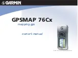
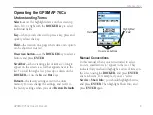
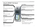
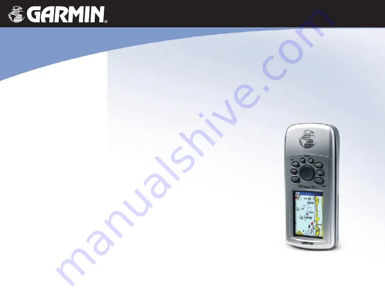
background image

GPSMAP

®

 76Cx

mapping gps  

owner’s manual

GPSMAP 76Cx shown with optional MapSource

®

 data.

Summary of Contents for GPSMAP 76Cx

Page 1: ...GPSMAP 76Cx mapping gps owner s manual GPSMAP 76Cx shown with optional MapSource data...

Page 2: ...any unauthorized commercial distribution of this manual or any revision hereto is strictly prohibited Information in this document is subject to change without notice Garmin reserves the right to cha...

Page 3: ...l of the display s backlight by quickly pressing and releasing the POWER key Product Registration Help us better support you by completing our online registration today Connect to our Web site at http...

Page 4: ...ceiver 4 Basic Operation 7 Creating and Using Waypoints 7 Using the Find Menu 11 Using Tracks 18 Creating a Route 22 Main Pages 25 Satellite Page 26 Map Page 26 Compass Page 29 Trip Computer Page 32 M...

Page 5: ...he screen a scroll bar appears next to the list To scroll through a list press up or down on the ROCKER or use the In and Out keys Default the factory setting saved in the unit s memory You can change...

Page 6: ...topography WARNING This product its packaging and its components contain chemicals known to the State of California to cause cancer birth defects or reproductive harm This Notice is provided in accor...

Page 7: ...d Unit Overview Carry lanyard attachment slots Battery compartment cover External Data Auxiliary Power Port Internal antenna Interface keys Auxiliary GPS Antenna Connector Battery compartment locking...

Page 8: ...al months Stored data is not lost when batteries are removed To install the microSD card 1 Remove the battery cover by turning the D ring 1 4 turn counter clockwise and pulling the cover loose 2 Locat...

Page 9: ...oom Keys Press to zoom in or out on the Map page Press to scroll up or down a list on any other page FIND MOB Key Press at any time to view the Find Menu Press and hold for MOB POWER Key Press and hol...

Page 10: ...satellite data and establish its current location To receive satellite signals you should be outdoors and have a clear view of the sky To initialize your GPSMAP 76Cx Hold the unit in front of you fac...

Page 11: ...l status is shown when searching for or acquiring satellites when a 2D fix is attained and when a 3D fix is attained The Backlight icon appears when the backlight is on The Backlight is off when you t...

Page 12: ...or an optional PC interface cable with a serial connector can be used to transfer MapSource CD ROM data to the microSD card Higher capacity and pre loaded microSD map data cards are also available Ma...

Page 13: ...ate a waypoint on the Map page or enter coordinates for a waypoint manually Marking Your Current Location Use the ENTER MARK key to quickly capture your current location creating a new waypoint You mu...

Page 14: ...ts 3 Select the waypoint you want to edit and press ENTER 4 Make changes by highlighting each field and use the waypoint symbol chart and alphanumeric keypad to enter new data To delete a waypoint Fro...

Page 15: ...ject Waypoint and press ENTER to open the Project Waypoint page 6 Enter the distance and bearing to the projected waypoint in the appropriate fields at the bottom of the page and press QUIT when finis...

Page 16: ...ity Alarms box to activate alarms As you approach a proximity waypoint a tone sounds and a Near Proximity Point message appears When you move outside the set radius a Leaving Proximity Point message i...

Page 17: ...of search options Select a category Find By Name Use Find By Name if you know the name of the location you want to find To find a location using Find By Name 1 Press FIND to open the Find Menu 2 Sele...

Page 18: ...s detailed information about the item Each information page contains three on screen buttons Different buttons appear depending on whether you are selecting an item to navigate to or adding an item Fi...

Page 19: ...ow the map from which the map item originated See the Appendix for information about downloading detailed maps To find an item near another item 1 Press FIND 2 Select an icon on the Find Menu 3 Select...

Page 20: ...che symbol to separate it from others For more information about geocaching log on to http my garmin com and click Go Geocaching To find a geocache 1 Press FIND 2 Highlight Geocache You can view found...

Page 21: ...erstate exit To find an interstate exit 1 Press FIND 2 Select Exits A list of interstate exits near your location is shown 3 Use the ROCKER to select an exit and press ENTER This page contains the exi...

Page 22: ...ersection This feature also requires detailed mapping data Follow the basic steps for finding an address when searching for an intersection Finding a Marine Point If using MapSource BlueChart marine c...

Page 23: ...aurants lodging landmarks and public buildings To find a point of interest 1 Press FIND 2 Select All Points of Interest to show a list of all points near your current location 3 Press MENU 4 Select an...

Page 24: ...centage of memory used List of saved tracks To clear the track log 1 Press MENU twice to open the Main Menu 2 Select Tracks 3 Select the Clear button A confirmation message appears 4 Select OK To set...

Page 25: ...age To save a portion of the track log 1 Press MENU twice Tracks 2 Select Save A message appears asking you if you want to save the entire track 3 Select No to save only a portion of the track log 4 U...

Page 26: ...oints are added to the track To calculate the area of a track 1 With the Track Log page open and the Track Log on press MENU 2 Select Area Calculation and press ENTER 3 Press ENTER to start the area c...

Page 27: ...navigating the TracBack 3 Select Follow Road to route back to the point using available roadways or select Follow Track to retrace your original path of travel The Map page gives directions to the fir...

Page 28: ...om one of the Find groups 4 Select Use to add it to the route 5 Select Navigate Methods for routing you to a destination If you select Go To on the Waypoint page or other Find items a straight path is...

Page 29: ...w Road or Off Road Using Follow Roads increases the number of turns and shows an Active Route page Select Off Road to view only a list of route points A Calculating Route message appears until the rou...

Page 30: ...oad Transition Route Leg Transition 3 Select Manual or Distance when advancing to the next point Select Distance to enter a radius so that when you are within the entered distance you are led to the n...

Page 31: ...ng the QUIT key to reverse Add additional pages by using the Page Sequence option on the Main Menu The Active Route page appears when you are actively navigating Each page has an Options Menu To view...

Page 32: ...ach satellite is shown in a different color or the same color New Location use if you have moved the unit more than 600 miles and you are having trouble locking onto satellite signals GPS Elevation sh...

Page 33: ...tional Map Data View listings such as nearby restaurants lodging shopping centers attractions and entertainment and you can retrieve addresses and phone numbers for any listed location when using opti...

Page 34: ...are selected Guidance Text shows messages on the screen advising you of your next navigation move Setup Map accesses to six pages of display options Measure Distance Stop Measuring measures the distan...

Page 35: ...n the two points is shown in the upper right corner Push pin indicating the beginning point of the measurement End point of measurement labeled REF Measured distance Compass Page The Compass page guid...

Page 36: ...y settings Using the Course Pointer or Bearing Pointer The bearing pointer and course pointer are independent of each other The bearing pointer indicates the direction to your destination and the cour...

Page 37: ...to the right or left to get back on course The Course Pointer indicates your course of travel from your original location and the distance off course 0 25 mi Scale To select the course pointer or the...

Page 38: ...ormation by highlighting Reset from the Options Menu and pressing ENTER The Reset page offers options for resetting trip computer data clearing the Track Log and deleting Saved Tracks Waypoints and Ro...

Page 39: ...e To select an item on the Main Menu highlight the menu item and press ENTER Main Menu NOTE If a page is added to the page sequence the page icon does not appear on the Main Menu Tracks For more infor...

Page 40: ...se the option menu to restore defaults read microSD card information or view the version of unit software and the Unit I D number Display Setup Page You can choose a display mode a color scheme for da...

Page 41: ...It also allows transfer of Track Log Data to Garmin MapSource To activate USB Mass Storage for HCx units 1 Connect the unit to a computer 2 Select USB Mass Storage and press Enter 3 Double click My C...

Page 42: ...new page select the page you want to insert if before press ENTER Insert Map Setup Page Use the Map Setup page to adjust how items are shown on the Map page To customize the Map page display 1 Press...

Page 43: ...ms the map scale to include the beginning and ending points of a route Detail selects the degree of map detail shown Lock On Road locks the map pointer to display on the nearest road compensating for...

Page 44: ...tions of map items on the Map page You can select from Small Medium or Large Map Setup Text Page Map Setup Information Page Use the Map Setup Information page to view a list of downloaded detailed map...

Page 45: ...e prompted to select a preference before the route is calculated Follow Road increases the number of turns the route contains Off Road creates a direct line from your current location to your destinat...

Page 46: ...culate Routes For set route calculation for the vehicle you are operating to optimize the route for your vehicle type Avoid avoid certain road types and maneuvers on your route Geocache Setup See the...

Page 47: ...n the unit Distance Speed sets the unit of measurement to show your speed and distance Elevation Vert Speed sets the unit of measurement Feet ft min Meters m min or Meters m sec Depth select the unit...

Page 48: ...watch From the Main Menu select Stopwatch Sun and Moon To access the Sun and Moon page From the Main Menu select Sun and Moon Hunt Fish To view predictions for a date and location From the Main Menu s...

Page 49: ...Source Two 1 5 volt AA batteries USB power 12 V Adapter Cable or up to 36 VDC external power Battery Life Up to 18 hours typical use Alkaline batteries lose a significant amount of their capacity as t...

Page 50: ...A devices The following are the sentences for NMEA 0183 version 3 01 output Approved sentences GPGGA GPGLL GPGSA GPGSV GPRMB GPRMC GPRTE GPVTG GPWPL GPBOD GPAPB The USB Interface Cable provided with t...

Page 51: ...otective cover from the back of the GPSMAP 76Cx and insert the round indexed connector on the cable into the matching port 2 Connect the remaining cable end to your PC Serial port or other appropriate...

Page 52: ...eflective coating It is important to clean the lens using an eyeglass lens cleaner that is specified as safe for anti reflective coatings and a clean lint free cloth Storage Do not store the GPSMAP 76...

Page 53: ...f and on the user is encouraged to try to correct the interference by one of the following measures Reorient or relocate the receiving antenna Increase the separation between the equipment and the rec...

Page 54: ...THER RESULTING FROM THE USE MISUSE OR INABILITY TO USE THIS PRODUCT OR FROM DEFECTS IN THE PRODUCT Some states do not allow the exclusion of incidental or consequential damages so the above limitation...

Page 55: ...S AND CONDITIONS OF THE FOLLOWING SOFTWARE LICENSE AGREEMENT PLEASE READ THIS AGREEMENT CAREFULLY Garmin grants you a limited license to use the software embedded in this device the Software in binary...

Page 56: ...eocache 14 intersection 16 interstate exit 15 waypoints 14 G games 42 geochache 14 40 GPS off on 34 guidance text 28 H heading setup 41 highway page 33 hunt and fish 13 I In Out zoom keys 3 initializi...

Page 57: ...4 T tide stations 16 time setup 41 time zone 41 tones setup 36 TracBack 21 tracks 18 track log record method 18 track up 28 turning on off 4 U units setup 41 USB mass storage 35 W warranty 48 water im...

Page 58: ...www garmin com 2007 Garmin Ltd or its subsidiaries Garmin International Inc 1200 East 151st Street Olathe Kansas 66062 USA Garmin Europe Ltd Liberty House Hounsdown Business Park Southampton Hampshir...

Reviews: