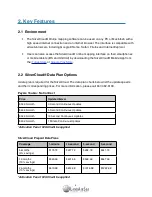
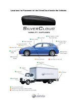
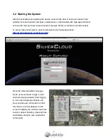
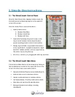
background image

1

SilverCloud

®

 User Guide

Real-Time GPS Tracking System

Summary of Contents for SilverCloud

Page 1: ...1 SilverCloud User Guide Real Time GPS Tracking System...

Page 2: ...3 THE SILVERCLOUD MAIN MENU SELECTIONS 12 5 3 1 HISTORICAL PLAYBACK 12 5 3 2 DEVICE EDITOR 13 5 3 3 GROUP EDITOR 13 5 3 4 SETTING GEOFENCE ALERTS 13 5 3 5 SETTING PROXIMITY ALERTS 15 5 3 6 ROUTING UTI...

Page 3: ...r the warranty and repairs require sending the device back to the manu facturer Cost for time and materials will apply Mounting this device under a vehicle also ex poses the unit to road hazards Becau...

Page 4: ...a Plan Options A data plan is required for the SilverCloud The data plan charts below list the update speeds and their corresponding prices For more information please call 847 462 8100 Pay As You Go...

Page 5: ...g the user when the vehicle enters or exits that zone Traffic Information Ability to indicate traffic and delays on the map by utilizing existing Google Maps traffic flow interface Routing Utility Off...

Page 6: ...deactivated a reactivation fee of 29 95 will be charged in order to restart service In order to cancel a data plan service the user must do so in writing This can be done by email and sent to activati...

Page 7: ...ttery case To access the switch open the battery compartment When the device is turned on the LED lights on the back panel will light up The device should be outdoors with a clear view of the sky befo...

Page 8: ...Locations for Placement of the SilverCloud Inside the Vehicles 8...

Page 9: ...ri is recommended To access the online system open the browser to the following website http www landairsea com silvercloud Once the SilverCloud home page loads users will need to type in their userna...

Page 10: ...m 4 4 Live Support Chat SilverCloud users will also be able to chat live with a support representative by clicking Live Support Chat feature located in the Main Menu Choose the Live Support Chat optio...

Page 11: ...iew predetermined virtual zones geofences navigational waypoints adjust best fit for multiple vehicles and view vapor trails as the vehicle moves along the map Zoom in and out by dragging the button u...

Page 12: ...a continuous loop 7 After the fields have all been set click Generate Playback 8 At this point Google Earth may request to install a plug in if it has not already been done Allow the plug in to be dow...

Page 13: ...eful when needing to view multiple vehicles but not necessarily all vehicles 1 To create a new group type the name of the group in the Name field 2 Then choose the vehicle which you would like assigne...

Page 14: ...tifications will be sent 9 Enter a message to be sent to the recipient you want to display in Custom Msg field 10 Click and drag the geofence oval or rectangle to the desired position on the map 11 Cl...

Page 15: ...address and or cell phone number 5 Set the distance for when the alert is to be triggered by checking the appropriate boxes 60 Miles 25 Miles 10 Miles Arrived etc 6 Once the Proximity Alert has been...

Page 16: ...Users will have the option to select the Show Directions box or Avoid Toll Roads box 5 Once the fields have been designated and set click on the Calculate Route button which will open another window...

Page 17: ...tly identify where the vehicle is at any time on a web browser without having to contact the user directly To utilize ShareSpot 1 Select Advanced Options from the Main Menu and then select the ShareSp...

Page 18: ...ssary for added security In this section users will also have the ability change their email address and set the desired timezone Sub Account For Security Reasons Sub Accounts have been disabled If us...

Page 19: ...enu which will then open a new window 2 Select the Create HTML box to view the report from a web browser 3 Select the Create PDF box to generate a file that can viewed with Adobe Reader Users will nee...

Page 20: ...vehicle and each instance that the vehicle exceeds the maximum speed for the selected time period will be displayed in the Excessive Speed Report 6 2 4 Complete Activity by Device Report The Complete...

Page 21: ...cation displays a hyperlink street address that corresponds to latitude and longitude point The location can be viewed in Google Maps by clicking the address 6 2 6 Mileage by State Report The Mileage...

Page 22: ...ery GPS device on the market today All GPS devices use this same process So the device may be working properly and tracking all of the right locations but the addresses might be off by a few numbers O...

Page 23: ...0mA during transmission less than 1mA at rest GSM Channels 850 1900 U S 900 1800 Europe Australia Asia Middle East Communication Protocol TCP UP UDP SMS Update Frequency 1 minute 10 second 5 second an...

Reviews: