background image

Summary of Contents for RoadExplorer 70

Page 1: ......

Page 2: ...om the GPS unit Consult the dealer or an experienced radio TV technician for help When using the device ensure that the antenna of the device is at least 20 cm away from all persons IC Compliance Statement This device complies with Part 15 of the FCC Rules and Industry Canada license exempt RSS standard s Operation is subject to the following two conditions 1 This device may not cause interference...

Page 3: ...such as mountains man made structures such as highway overpasses bridges and tall buildings as well as weather can interfere with the GPS signal For best GPS reception position the device and mount with a clear line of sight to the sky Some vehicles may have a limited view of the sky due to metal sun shields or a metallized windshield coating Map data includes the geographical coordinates for addr...

Page 4: ... Planner 22 Tell Rand 23 Unit Converter and Calculator 24 Go to Map 25 Exits Quick View 26 View Directions 27 Virtual Dashboard 28 Junction View and Turn View 30 Location and Route Options 31 Traffic 32 Weather 34 Fuel Prices 35 Add Avoid Location Set Origin Begin New Route 36 Choose Destination 38 Helpful Tips on Entering Addresses 39 New Location 40 Search for an Address 41 Route to a City Cente...

Page 5: ...does not pose a risk in the event of an accident Do not run cables directly next to safety relevant devices and power supplies After installation check all safety relevant equipment Connect the wall charger to a 120V or 240V outlet only Connect the vehicle charger to a 12V outlet only 1 Your Device Care and Maintenance Do not use sharp edged objects on the device touch screen The device is not wat...

Page 6: ... sky and GPS satellites 2 Clean and dry the mounting area 3 Remove the suction cup protective film 4 Attach the two pieces of the mount together and lock into place 5 Pull the suction cup lever up to release suction 6 Place and hold the mount suction cup against the mounting surface 7 Push the suction cup lever down towards the windshield until it snaps into place 8 Snap the tablet onto the mount ...

Page 7: ...Road Explorer 70 User Manual 3 1 Your Device Main Menu Volume Down Up Power Dash cam USB Micro SD Audio out Road Explorer 70 Hardware ...

Page 8: ...tures such as weather and traffic Choose your wireless access point or hotspot from the list and type in your password Note If you skip this step you will not be able to use all the features of your tablet The GPS app however does not require a Wi Fi connection Registration In the next step you ll be prompted to register your tablet with Rand McNally Your registration ensures that you have access ...

Page 9: ... Settings panel will display The Quick Settings panel contains often used features that can be adjusted according to your personal preference See Settings on page 6 for further information Swipe down at the top left of the status bar and your Notifications panel will display The tablet notifies you when something needs your attention such as an e mail text message or device update 1 GPS Signal 2 W...

Page 10: ...sed features Brightness Settings Access full menu of all settings Wi Fi Shows available networks Auto Rotate Controls whether the screen rotates when you rotate the tablet Battery Power Airplane Mode Turns off Wi Fi and data transmission Bluetooth Pairs other devices Location Set mode high accuracy recommended Screenshot Saves an image of the current screen ...

Page 11: ...t apps More Choose Airplane mode Tethering portable hotspot Ethernet VPN Mobile networks Device Home Select a different launcher This will change the home screen that appears when the tablet powers on Sound Set volumes for different features and enable disable sounds Display Set brightness wallpaper and appearance Storage View how much internal storage is available on your tablet Battery View time...

Page 12: ...put Set language and keyboard information as well as speech options and pointer speed Backup reset Back up the data stored on your tablet Also reset the device to its factory settings Accounts Add accounts Add your email or other accounts System Date time Set date time time zone and date and time format Accessibility Enable spoken feedback captions and large text to help visually impaired users Pr...

Page 13: ...ect a shortcut or tap applications to view more Tap Save 2 GPS See How the GPS App Works on page 10 3 TripMaker Use the online planning tool to plan a trip with multiple via points and transfer it to the navigation app as a multi stop trip See TripMaker on page 54 4 Backup Cam requires accessory 5 Dash Cam See Dash Cam on page 56 for more information 6 Road Atlas See Road Atlas on page 55 for deta...

Page 14: ...l provide accurate GPS location even without a Wi Fi connection Weather traffic fuel prices local search within the GPS app and device updates require a Wi Fi connection To exit the GPS app at any time swipe down from the top of the screen or up from the bottom to view the Android menu bars Or tap the main menu button on the front of the device ...

Page 15: ... Tap to view location on the map 3 Choose Destination Tap to select an address or point of interest POI 4 Preferences Tap to set general route or map settings Mute Unmute the Speaker Tap to mute or unmute spoken instructions Note You can also tap this icon when it appears on the map screen to mute unmute Volume Tap to increase or decrease spoken instructions volume 1 2 3 4 5 6 6 5 ...

Page 16: ...ançais For the screen and spoken instructions Units U S Standard Metric Auto Select Clock Setting 12 Hour Clock 24 Hour Clock Preferences Skin Style Day Ice Carbon Skin Style Night Ice Carbon Home Time Zone Hawaii Alaska Pacific Time Arizona Mountain Time Central Time Eastern Time Indiana East Atlantic Canada Newfoundland Day Night Mode Always Day Always Night Automatic Auto Switch Offset Automati...

Page 17: ...oid U Turns Ferries Allow Ferries Avoid Ferries Cross Country Borders Allow Crossing Borders Avoid Crossing Borders Dirt Roads Allow Dirt Roads Avoid Dirt Roads Tunnels Allow Tunnels Avoid Tunnels Manage Avoid List Roads States Provinces Areas Routes Fast Recalc Off On Turn Announcements Set three distances at which you want to be warned about an upcoming turn The first announcement will be the fa...

Page 18: ... left or right to set the route color Map Preferences Options Preferences continued Map Style Light Dark EZ View Map Auto Zoom Off On Auto Scale On Street Scale On City Scale On State Scale Set to auto scale to keep the current vehicle position and the next turn in the map view at all times Set to street city state scale to specify the maximum scale of the zoom Note When in 3D Map mode with Auto Z...

Page 19: ...ion 4 Warnings Set the distance at which the device alerts you when there is an upcoming state province border time zone toll booth construction area or speed limit change 5 Quick Planner Between any two cities or towns quickly calculate the distance driving time and cost 6 Tell Rand Compose a message to send to Rand McNally 7 Converter Quickly convert distance temperature weight and volume 8 Calc...

Page 20: ...nd buttons State or Province Border Off Timezone Change On Toll Booth Alert Set warning distance to toll booths by using the and buttons Construction Area Set warning distance to construction areas by using the and buttons Speed Set warning distance to speed limit changes by using the and buttons Set the amount over the posted limit at which the warning appears Set a user defined maximum speed to ...

Page 21: ... Mile Marker Incorrect Toll Find Location Speed Limit Correction Add Remove Location Address Road Change New Road Construction Info Correction Routing Suggestion Concern Vehicle Restriction Correction Usability Suggestion Concern New Idea Feature Service and Repair Incorrect Mile Marker Incorrect Toll Current location Speed Limit Correction Add Remove Location Address Road Change New Road Construc...

Page 22: ... important phone numbers for states and provinces in the U S and Canada and key facts and important phone numbers for Mexico 1 Tap Tools 2 Tap Road Atlas Information 3 Select the appropriate country tab 4 Select the appropriate state province to view key facts emergency phone numbers and other key phone numbers ...

Page 23: ...ecklist to use it or modify it or 4 Tap Custom Checklist to create a new one Maintenance Use the maintenance feature to track your vehicle s maintenance records such as oil changes or repairs You can also use it to make a note of serial numbers model information or other purchase details for appliances or components for your vehicle 1 Tap Tools 2 Tap Checklists Maintenance Trails Fuel 3 Tap Maint ...

Page 24: ...Trails 4 To record a trail tap New Trail 5 To end the trail tap the Trails icon on the map screen The trail is recorded in the Trails tab 6 Tap a trail to view details 7 Tap Show on Map to display the trail on the map screen 8 Tap Edit Name to change the name of the trail 9 Tap Set Color to change the color of the trail Note The Trails feature is also accessible from the Address Book See Address B...

Page 25: ...Tap Checklist Maintenance Trails Fuel 3 Tap Fuel to view a list of fuel logs by quarter 4 Tap Add Fuel to record the date location and cost of fuel purchase 5 Tap on any field to edit 6 Tap Save Note Fuel economy is calculated automatically 7 Once fuel purchases have been entered select a timeframe Year Q1 Q2 Q3 or Q4 to view the details 8 You can also View by State ...

Page 26: ...splays 3 Tap From City 1 and select the city 4 Tap To City 2 and select the city The distance displays 5 Tap Cost per Mile and enter the per mile rate or tap Total and enter the total amount 6 Tap the new dollar amount and tap Enter 7 The dollar amounts readjust automatically 8 Tap Average Speed MPH to enter a speed Tap or to decrease or increase the speed Tap the calculator to enter a speed 9 Tap...

Page 27: ...eed limit message by tapping the speed limit or mile marker on the map screen 4 If you selected Enter Different Location enter it as an address If you selected Find Location on Map tap on the map to set the crosshairs at that location then tap Back 5 Tap the type of message on the right side of the display 6 Type your message 7 Tap Enter to save the message or 8 Tap Back to discard the message and...

Page 28: ...culator To access the unit converter 1 Tap Tools 2 Tap Converter 3 Tap on the first field and select the type of conversion to perform 4 Tap on the second field and enter the value to be converted 5 Tap Enter To access the calculator 1 Tap Tools 2 Tap Calculator ...

Page 29: ...t location information change route settings detour cancel a route and manage avoided roads Current Speed Tap to display the Virtual Dashboard Turns red for speed warnings Speed Limit Tap to open a Tell Rand message about speed limits 15 Map View Tab Tap to simplify the map screen Icons are minimized to show simply the zoom next maneuver and miles time 1 Next Maneuver Tap to repeat spoken instruct...

Page 30: ...Interest and amenities at upcoming exits The list displays the distance to the next exit exit name and number and a count of available amenities 1 Tap an exit to bring up the list icon 2 Tap the icon to display locations by category 3 Tap any item in the list to route to that location ...

Page 31: ...rrent vehicle speed in miles per hour 3 Distance Time Displays remaining distance and time 4 Distance Displays the distance for each road segment 5 Street Road Name Displays the street name you will be on after performing the next maneuver Tap any item in the list to view it on the map and to detour around it if necessary Note For multi stop trips highways in each leg are listed color coded by seg...

Page 32: ...g exceeded 6 Gather trip information for up to three trips Includes odometer settings hours and speeds 7 Percentage of current trip completed distance to next maneuver and the number of miles and time spent on the trip to this point 8 Match with vehicle s odometer to automatically update new fuel logs Tap the pencil to edit 9 Reset trip information for the selected trip Tab 1 Tab 2 or Tab 3 10 Sel...

Page 33: ...on is captured as you travel the route Automatically Reset Trip Information To reset trip information after the vehicle has remained stationary after a specific number of hours 1 Tap the tab you want to reset 2 Tap Auto Reset 3 Tap to increase the number of hours 4 Tap to decrease the number of hours 5 To save changes tap Change 6 The tab displays the auto reset number of hours ...

Page 34: ...Distance Once past the maneuver Junction View closes and the previous window displays 1 Signs to follow for the next maneuver 2 Number and direction of lanes for the next maneuver 3 Distance to the upcoming maneuver Distance decreases as you approach the ramp 4 Lane assist arrow 5 Return to previous window Turn View Displays for upcoming turns Set distance in Preferences Route Turn View Distance 3...

Page 35: ...miles to be avoided The route is recalculated Around a Specific Roadway 1 On the right side of the window tap and to view a list of roads in the current route 2 Tap one or more roadways to be avoided A check mark appears in front of each selected road 3 Tap Detour to recalculate the route Note Tap Cancel Detour to remove detours 7 Detour the entire route and add it to the avoid list 8 Skip to next...

Page 36: ... a recalculated route based on traffic events or to stay on the current route 3 Traffic on Route Tap to view traffic events along your route 4 Traffic List Tap to view a list of traffic events in the area 5 Traffic Source Tap to change 6 Map Menu Tap to return to the map or Main Menu 7 Day Time Choose the day of the week and time Use the arrows to set the time 8 Detailed list Tap any item to view ...

Page 37: ...locked Traffic Carpool Road Work Obstruction Dangerous Road Condition Temperature Wind Activities Security Delay Cancel Size Weight Limit Visibility Heavy Traffic Moderate Traffic Light Traffic Travel Time Chance of Precipitation Accident Accident Incident Closure Carriageway ...

Page 38: ...iew details for current weather alerts 2 Select type of weather overlay to display on the map 3 View weather information at your destination Note You can view weather information at any other location by tapping the map and then the Wi Fi icon and the Weather tab 4 Select from a variety of weather types to display on the map No weather turn off Traffic impact Temperature Feels like Current precipi...

Page 39: ...on To show fuel prices tap the Wi Fi icon on the map screen and tap Fuel Prices 1 Displays stations and prices with distance as the crow flies Check to show the icons and prices on the map screen Sort by distance or price Apply filters for type of fuel and specific brand Check to show fuel prices along the route ...

Page 40: ... and the destination 2 Permanent Avoid Tap to avoid the route road or area or to detour 3 Set Origin When you tap the map the crosshairs display and you can set the origin The origin is the starting point of the route 4 Route to Here Tap Begin New Route to navigate to the location 5 Wi Fi View live information such as weather and fuel prices at this location if your device has a Wi Fi connection 3...

Page 41: ...ooming in or out to be sure to select the right location Road segments that have been permanently avoided are shown in pink on the map when zoomed in Tap on a segment and tap Remove Avoid to remove the segment from the Avoid List Detour Detour around a road segment on an active route The route is recalculated but the road segment is only avoided temporarily and does not appear on the Avoid List To...

Page 42: ...f saved locations 5 Multi Stop Trips Tap to view a list of saved multi stop trips or to create a new one 6 Points of Interest POIs Tap to search for a point of interest POI such as a gas station restaurant roadside attraction etc Local Search Tap to search for local businesses restaurants and more by name or keyword Note Wi Fi connection required Rand McNally Trips Tap to search for recommended ro...

Page 43: ...u are looking for displays in the list Streets If the next letter in the street name cannot be selected on the keyboard tap Expand Search to search a greater area The Expand Search button can also help locate addresses that may actually be in a different town or spelled slightly differently Note If you re entering a State or County Route it s usually best to first either enter the State or County ...

Page 44: ...2 Address Tap to route to an address by entering the city street and number or by entering the zip code and street 3 City Center Tap to route to a city center 4 Intersection Tap to route to two intersecting roads in a city 5 Enter Lat Long Tap to route to a location by latitude and longitude 6 Menu Tap to return to the GPS Main Menu 3 GPS 2 3 4 1 5 6 ...

Page 45: ...r instead of entering the city name tap Enter Zip Code and type the zip code 5 Type the first few characters in the street name or if the next characters of the street name cannot be selected on the keyboard tap Expand Search and search a wider area 6 Tap the street name from the displayed list 7 Tap the house number or tap List to show a list of address ranges and select a range Note To enter the...

Page 46: ...stination New Location Intersection 2 Type the first few characters in the city name 3 Tap the city name 4 Type the first few characters in the primary street name or if the next characters of the street name cannot be selected on the keyboard tap Expand Search and search a wider area 5 Tap the street name in the list 6 Type the first few characters in the intersecting street name 7 Tap the inters...

Page 47: ...e of the location and tap Enter 4 Tap in the Longitude field 5 Enter the longitude of the location and tap Enter 6 Tap Go The Confirmation Window displays See Destination Confirmation Windows on page 52 7 Tap Begin New Route to navigate to the location Note There are two ways to enter latitude longitude by decimal degrees or by degrees minutes and seconds 3 GPS ...

Page 48: ...o the Address Book from the Confirmation Window See Destination Confirmation Windows on page 52 1 Tap Save to Address Book from the Confirmation Window 2 Tap Yes to accept the default name 3 Or tap No to display a keyboard and type the name of the location 4 Tap Enter to save the location in the Address Book The Confirmation Window re displays Route to an Address Book Location 1 Tap Choose Destina...

Page 49: ...to a Group 1 Tap Choose Destination Address Book 2 Tap Groups 3 Tap the group you want to add an address to 4 Tap New Location 5 Tap Enter New Address History Address Book or POI 6 If you selected Enter a New Address tap Address City Center or Intersection to enter the address or 7 If you selected History Address Book or POI the selected location is added to the group Remove an Address from a Grou...

Page 50: ...r you want to route to them or reorder stops later From the Main Menu 1 Tap Choose Destination Multi Stop Trips 2 Tap the route 3 Tap Add Locations 4 To add a destination tap Enter New Address History Address Book or POI then enter the desired information A Confirmation Window asks if you want to add another stop 5 Tap Yes to add another stop or No if the route is complete 6 Tap Back to save chang...

Page 51: ...irst stop or No Preference 6 Tap Select Last Stop and select the last stop or No Preference 7 Tap Yes to return to your current location to complete the route or No to complete the route at the last stop 8 Tap Start Trip to begin the route Note There is a limit of ten stops that can be optimized automatically Reorder a Route Manually 1 Tap Choose Destination Multi Stop Trips 2 Tap the route you wa...

Page 52: ...the following three options Next Stop To calculate a route to the next stop in the route Skip Next Stop To skip the next stop and calculate a route to the stop after the next one End Current Trip To end the route at the current stop Note To view your entire trip select Summary Map View from the Route Display Options Delete a Route 1 Tap Choose Destination Multi Stop Trips 2 Tap the next to the rou...

Page 53: ...nt vehicle location 3 City Tap to search for a point of interest in a city 4 My Route Tap to search for a point of interest along the vehicle route 5 My Destination Tap to search for a point of interest near the route destination 6 Custom POI Tap to select a Scenic Overlook Pass or State High Point 7 Main Menu Tap to return to the Main Menu 3 GPS 2 4 1 7 5 3 6 ...

Page 54: ...tination 3 Tap Other Categories 4 Tap a category For example tap Hospital Emergency 5 If necessary tap a subcategory type For example tap Pharmacy 6 Tap a location from the list and select the POI name or 7 Tap Spell to display the keyboard and type the first few characters in the POI name 8 Tap List The tablet searches for names 9 Select a name from the list 3 GPS ...

Page 55: ...name keyword or category Tap Choose Destination Local Search Choose a local search near My Car City or My Destination Select a category or tap Keywords to search using a specific name e g Subway or a keyword e g sandwich Tap Nearby Food to show a list of area restaurants based on your current location Tap My Local History to show a list of previous searches 3 GPS 1 2 3 4 5 1 2 3 4 5 ...

Page 56: ...es the current route a multi stop trip Save to Address Book Add to Group Add the location to the Address Book or add to Address Book group Atlas Cross reference to printed Rand McNally Motor Carriers Road Atlas Page numbers apply to the most recent Atlas Go to Map Tap to view this location on a map Set Origin Tap to set the location as the starting point of a route Main Menu Tap to return to the G...

Page 57: ...ion window tap Compare Routes to calculate and display two routes and choose between them 2 The top of the screen displays the total distance and time for each route Zoom in to get a closer look at each route on the map 3 Tap either button at the top of the screen to select that route ...

Page 58: ...your itinerary 3 Directions Once your trip is created tap this icon for driving directions 4 My Trips Access trips that you have created 5 Points of Interest Search categories along your route such as The Great Outdoors Arts Music and Shopping 6 Search Search for an address or place along your route 7 Create a Trip Enter addresses cities states or zip codes to create a trip Add stops as needed Tri...

Page 59: ...oad Atlas is a digital version of Rand McNally s Road Atlas 1 Legend Tap Legend at the top right of the screen to view the roads and related symbols Maps Tap Maps at the top right of the screen to to select pages by state area You can also update maps here 2 2 1 2 ...

Page 60: ...videos Use the table below to choose Quality Segments and Length based on the space used Video Quality Number of Segments Length of Segments Minutes Disk Space Used Low 4 1 43 26 MB Low 9 5 486 MB Low 15 10 1 58 GB High 4 1 89 MB High 9 5 1006 MB High 15 10 3 28 GB Animated GIF Files These are generally smaller than videos but because they capture a series of still images they look more like time ...

Page 61: ...r Truck It Smart Transflor Mobile Profit E Logs for Rand McNally HD 100 requires accessory etc Backup Cam Requires accessory Predictive Traffic Add to GPS app Choose a weekday and time to view typical traffic conditions based on historical data See Traffic on page 33 Traffic Everywhere Add to GPS app Adds up to more than 260 000 miles of traffic flow on highways and arterial roads in the U S and C...

Page 62: ...er 70 User Manual 58 For More Information Rand McNally Website www randmcnally com Support www randmcnally com support GPS accessories store randmcnally com Facebook www facebook com randmcnally 8 More Information ...

Page 63: ...cNally 2016 HERE All rights reserved Rand McNally follows a continuous improvement process and reserves the right to provide enhancements that may not be reflected in the pictures and specifications in this manual The information contained herein may be changed at any time without prior notification Neither this manual nor any parts thereof may be reproduced for any purpose whatsoever without the ...

Page 64: ...RE70MANUAL 052016 v001 ...
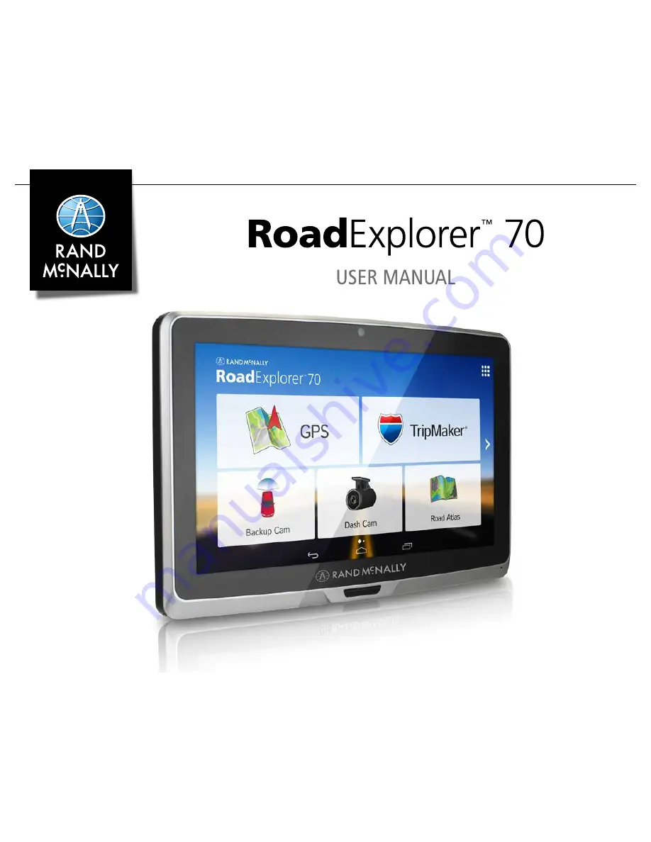
Reviews: