background image

CP150C

GPS Chart plotter

Owner's Manual

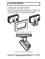
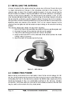
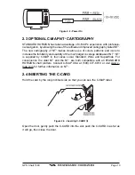
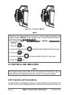
Summary of Contents for CP150C

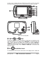
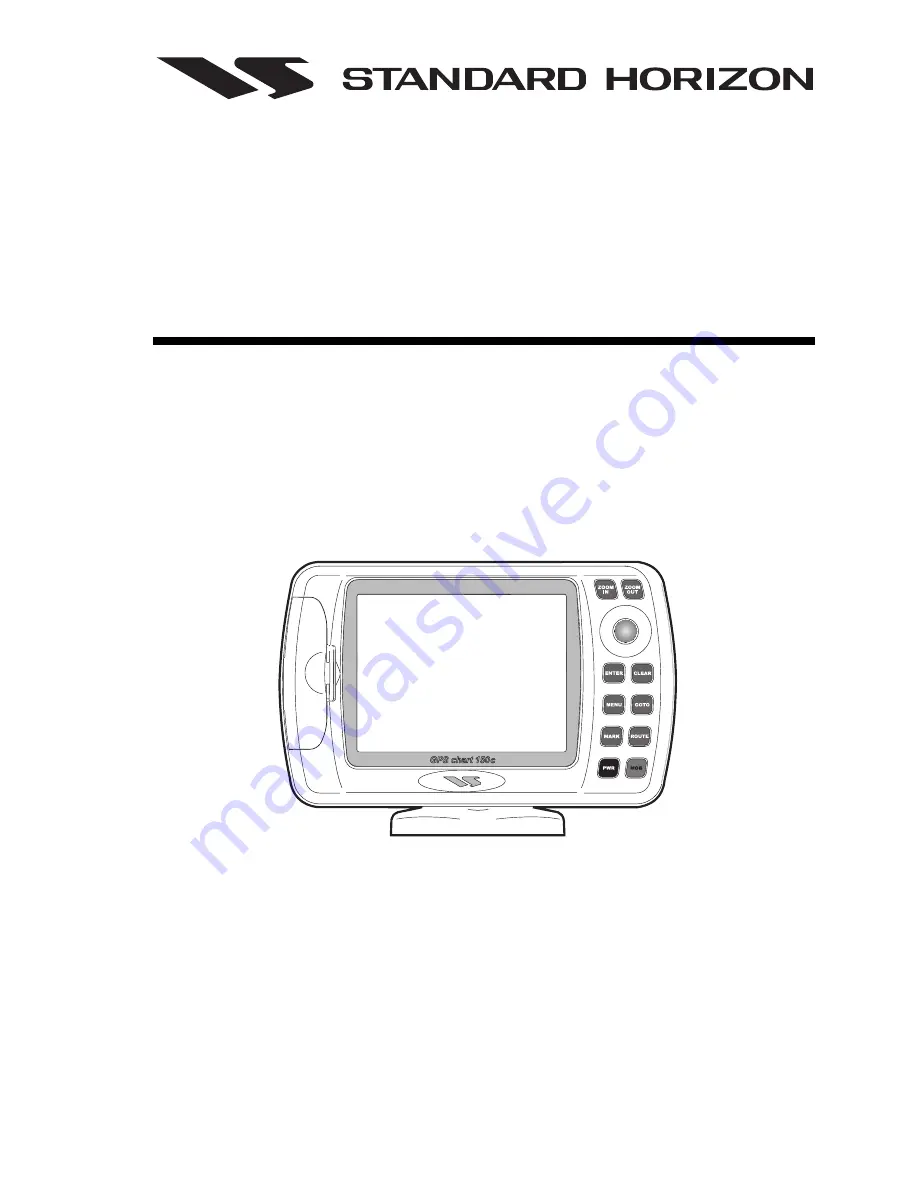
Page 1: ...CP150C GPS Chart plotter Owner s Manual ...

Page 2: ...ION 19 2 13 NAVIGATING TO A MARK 19 2 14 ENTERING LORAN TD S 20 2 15 TRANSFER MARKS FROM PC OR OTHER GPS 20 2 16 SELECTING NORTH UP OR COURSE UP 21 2 17 CUSTOMIZING DATA WINDOWS ON CHART PAGE 21 2 17 0 Selecting Data Window layout 22 2 17 1 Customizing Data box 22 2 18 CUSTOMIZING DATA WINDOWS ON ANY PAGE 22 2 19 PAGES 23 2 19 0 Selecting pages 23 2 20 HOME MODE VS CURSOR MODE 23 2 20 0 Cursor Mod...

Page 3: ...MOB FUNCTION 41 3 10 0 Using MOB function 41 3 10 1 Deleting MOB 42 3 11 TRACK PLOTTER FUCTIONS 42 3 11 0 Selecting Time and Distance 42 3 11 1 Selecting a track line color 42 3 11 2 Turning on or off the Track plotter 42 3 11 3 Saving a track to memory 43 3 11 4 Displaying track 43 3 11 5 Deleting track 43 3 12 MAINTENANCE 43 3 13 SPECIFICATIONS 44 3 13 0GPS Receiver Specifications 45 3 13 1GPS A...

Page 4: ...her pages 58 About page 58 3 15 4User Settings 58 3 15 4 0Map Customization 58 3 15 4 1 Display Settings 59 3 15 4 2Customize Map 59 Marine Settings 59 Depth Settings 60 Land Settings 61 Chart Settings 61 3 15 4 3General Setup 62 3 15 4 4Fix 63 3 15 4 5Navigate 63 3 15 4 6Compass 64 3 15 4 7Input Output 64 3 15 4 8Alarms 64 3 15 4 9Simulation 66 3 15 5 Automatic Info 66 3 15 5 0Info Tree and Expan...

Page 5: ...ANDARD HORIZION dealer or other qualified service technician if the problem cannot be corrected Operation is subject to the following conditions 1 This device cannot cause harmful interference and 2 this device must accept any interference received including interference that may cause undesired operation Congratulations on you purchase of the GPS Chart CP150C Whether this is your first chart plot...

Page 6: ...tention to avoid water intrusion into the C MAP NT C CARD cartridge holder Extensive exposure to heat may result in damage to the chart plotter The chart plotter contains dangerous high voltage circuits which only experienced technicians can handle STANDARD HORIZON will not be liable for errors contained herein or for incidental or consequential damages in connection with the perfor mance or use o...

Page 7: ...ds NMEA Data pages 2 NMEA Output and 3 Inputs Connections to and from STANDARD HORIZON DSC VHF s for Distress and Position Request calls 3 year limited warranty lifetime flat rate 1 1 PACKING LIST When the package containing the chart plotter is first opened please check for the following contents If any parts are missing contact the dealer this chart plotter was purchased from Accessories and rep...

Page 8: ...Page 10 GPS Chart 150C 1 2 OPTIONS Part Number Item RR150003CP Overhead mounting bracket Figure 1 2 Bracket ...

Page 9: ...d If you decide to overhead bracket mount the CP150C STANDARD HORIZON offers a overhead mounting bracket part number RR150003CP that will be needed for this installation For Flush mounting please use the template and hardware supplied Figure 2 0 Installing removing chart plotter Figure 2 0a Optional overhead mounting bracket ...

Page 10: ...na must be tightened until the antenna stops rotating on the antenna mounting bracket The antenna design also allows for easy flush mounting 1 Drill a inch hole in an area that was verified to receive satellite signals well 2 Unscrew the base of the antenna and remove the gasket 3 Thread the cable though the hole and route to the plotter 4 Apply a small coat of RTV to the underside of the antenna ...

Page 11: ...lity of the much larger coverage database of NT NT is supplied by C MAP in four sizes Local Standard Wide and SuperWide For convenience the older NT and the NT are both compatible with all STANDARD HORIZON chart plotters Contact C MAP USA at 508 477 8010 or visit www c map com for further information on NT 2 4 INSERTING THE C CARD Hold the card by the long inclined side so that you can see the C M...

Page 12: ...the ShuttlePoint knob to select the ADVANCED SETUP menu item 3 Press the key 4 Use the Shuttlepoint to select the INPUT OUTPUT menu item 5 Press the key 2 5 CONTROLS AND INDICATORS NOTE This section defines each control of the chart plotter For instructions refer to Getting Started and Advanced Operation sections of this Owner s Manual 2 5 0 Controls and Connections The chart plotter is controlled...

Page 13: ... detail of a smaller area by changing the chart scale and zooming in on your display Press ZOOM OUT to change the scale and show a wider otherwise less detailed view Pressing and holding ZOOM IN ZOOM OUT allows the quick zoom that is the fast change of the chart scale where only the land areas are drawn When ZOOM IN ZOOM OUT is released all map details are shown The ShuttlePoint knob The ShuttlePo...

Page 14: ... clears the function If pressing MENU for 3 seconds from map display activates Edit mode to choose data to be shown in General 1 Line Small 1 Line Large 2 Lines Small Highway or Compass windows If pressing MENU for 3 seconds from Data pages Navigation Highway GPS Status NMEA Display allows to customize all data fields shown in the selected page The key Allows the user to select a Destination point...

Page 15: ...r on the screen If you release PWR before the countdown timer reaches zero the chart plotter will remain on 2 7 CHANGING SHIP ICONS The ships icon can be changed to the following Figure 2 7 Ships icons To change the icons press MENU GENERAL SETUP ENTER SHIP ICON ENTER 2 8 ADJUSTING CURSOR SPEED The cursor speed may be changed from moving slowly medium or fast The cursor speed can be controlled on ...

Page 16: ... TIME The time information supplied by the GPS satellites is in Universal Time Coordinates UTC or Greenwich England Mean Time To change the chart plotter to read the correct time first you must figure out the offset and if it is daylight savings time For example on the West coast of the United States or Pacific Standard Time the offset needed would be 08 00 or 07 00 for daylight savings time Easte...

Page 17: ... Longitude is close to the position you want to enter 2 Press ZOOM IN to a low scale 02 NM Move the cursor to the exact position and press MARK 3 Press ENTER to edit the Mark change icon and name With the User Points List 1 Select the User Points List and press MARK 2 Move the ShuttlePoint knob to the left until the Latitude and Longitude is highlighted and press ENTER 3 Press the up or down posit...

Page 18: ...ss MENU and select ADVANCED SETUP ENTER NAVIGATE ENTER COORDINATE SYSTEM ENTER TD press ENTER 2 Select the Chain and the Pair of the Loran and press ENTER 3 Press CLEAR until the Chart page is shown 4 Press MARK to make a Mark at your current location 5 Press ENTER for more options 6 Select EDIT and press ENTER 7 Press the ShuttlePoint knob to the left until the TD s are highlighted and press ENTE...

Page 19: ...nd select RECEIVE press ENTER 3 On the GPS Utility program send the Marks B Transmit saved Marks to the GPS Utility program good for backup 1 Press MENU and select USER POINTS LIST press ENTER 2 Move the ShuttlePoint knob and select SEND press ENTER 3 On the GPS Utility program receive the Marks 2 16 SELECTING NORTH UP OR COURSE UP Press MENU ADVANCED SETUP ENTER NAVIGATE ENTER MAP ORIENTATION ENT...

Page 20: ...op down menu Move the Shuttlepoint knob to select the item ex COG and press ENTER NOTE If the selected data type ex COG has different units of measure the list of units will automatically be shown to the left of the main drop down menu after pressing ENTER 3 Press CLEAR when finished to store the selections See previous Figure 2 17 2 18 CUSTOMIZING DATA WINDOWS ON ANY PAGE On the Chart Navigation ...

Page 21: ...page and press ENTER 2 20 HOME MODE VS CURSOR MODE The CP150C has two cursor modes of operation on the Chart page 2 20 0 Cursor Mode You will notice when the Chart page is selected and fix is received that your position will be shown by If you move the ShuttlePoint knob in any direction a cursor will be shown The cursor can be moved anywhere on the page called panning and if moved over the top of ...

Page 22: ...function to operate Press CLEAR to enable Home Mode function 2 20 1 Home Mode When a fixed is received the vessels position will be shown by a When in Cursor Mode and CLEAR is pressed the chart plotter will center the chart on the received boat position If the received position changes the map moves so that the chart is always centered on the vessel s position Zooming In Out is centered on the ves...

Page 23: ...h worldwide background cartography while the detailed charts of the desired area are available on data cartridges To customizing data window and box refer to section 2 17 0 and 2 17 1 Figure 3 0 Charts and general text area 3 1 NAVIGATION DATA PAGE MENU NAVIGATION ENTER This page is useful for to show information when heading to a destination This page shows a compass ruler fixed position and the ...

Page 24: ...scale of the Highway display can be changed by pressing ZOOM IN ZOOM OUT The ranges available are 0 2 0 5 1 0 2 0 4 0 and 10 NM Figure 3 2 Highway page 3 3 CELESTIAL PAGE MENU CELESTIAL ENTER This page displays the Moon Phases Sunrise Sunset time and Low Water High Water level at the current location The day can be moved in the calendar by moving the ShuttlePoint knob to the left right ZOOM IN ZOO...

Page 25: ... to the Chart page after a GPS Fix is received Figure 3 4 GPS Status page 3 5 VHF RADIO DSC LOG PAGE MENU DSC ENTER LOG ENTER Used when connected to a STANDARD HORIZON VHF capable of outputting NMEA DSC information There are two selectable pages Distress Call and Position Request Call The CP150C stores VHF Digital Selective Calls in the appropriate pages for fast recall and review on the Chart pag...

Page 26: ...4 1 for connections The chart plotter is capable of displaying information from the following devices that have a NMEA output Depth Sounder Speed Log Temperature Wind speed and direction along with GPS information 3 6 0 Display page MENU NMEA DISPLAY ENTER DISPLAY ENTER The number of fields shown is selectable by moving the ShuttlePoint knob to the right or left It is possible to customize all fie...

Page 27: ...3 6 2 Depth Trend page The chart plotter is capable of graphically showing information from the following NMEA devices Depth sounder Wind Speed and Temperture There is also a graph that records Speed Over Ground from the GPS 3 6 2 0 Page selection To select the pages follow the procedures below a Depth Trend page MENU NMEA DISPLAY ENTER DEPTH TREND ENTER b Wind Speed Trend page MENU NMEA DISPLAY E...

Page 28: ...ER POINTS LIST and press ENTER b Move the cursor over a Mark A pop up information window will be shown Press ENTER and select DIRECTORY from the pop up information window and press ENTER User Points List will be shown Press MARK A pop up information window will be shown with icon type name coordinates Distance and Bearing to the current location Press MARK to accept The new Mark is added in the Us...

Page 29: ...R 3 7 0 3 Moving a Mark Figure 3 7 0 3 Moving Mark I Place the cursor over the top to Mark to be moved and press ENTER Select MOVE and press ENTER By moving the cursor with the ShuttlePoint knob a dotted line connecting the Mark with the new position will appear When the Mark is at the desired position press ENTER to place the Mark at that position Figure 3 7 0 3a Moving Mark II Figure 3 7 0 3b Mo...

Page 30: ...Route a Move the cursor to a position that you want to place the starting point of the Route and press ROUTE This places a Waypoint on the chart A pop up window will appear showing information related to the Waypoint b To change the name of the Route press ENTER select EDIT press ENTER again and edit the name using the ShuttlePoint knob c To place the first leg of the Route move ShuttlePoint knob ...

Page 31: ... next Waypoint is shown Figure 3 8 1a Deleting Waypoint II 3 8 2 Moving a Waypoint Place cursor on Waypoint Press ENTER Select MOVE and press ENTER Use the ShuttlePoint knob to move the cursor A dotted line connecting the Waypoint to the new position is shown Figure 3 8 2 Moving Waypoint I To place the Waypoint in the new position choose the new place and press ENTER CLEAR to abort the move Waypoi...

Page 32: ...elete Route Place cursor on Route leg Figure 3 8 3 Placing Waypoint between two existing ones I Press ENTER Select INSERT and press ENTER The line between the two Waypoints is turned into a dotted line move the cursor to the new position The line will rubber band drawing a dotted line between the last Waypoint and the cursor and another dotted line between the cursor and the next Waypoint Figure 3...

Page 33: ...ENTER to modify a Waypoint A window will be shown with name symbol and Latitude Longitude of the Waypoint Figure 3 8 4 Edit Waypoint I Use the ShuttlePoint knob to select the field If you have selected name field press ENTER use the ShuttlePoint knob to insert the character 10 characters max then press ENTER If symbol field is selected press ENTER a window with 16 different symbols appears Figure ...

Page 34: ...ew information Figure 3 8 4b Edit Waypoint III 3 8 5 Route Report page Information on a Route Place cursor on Waypoint Press ENTER Select REPORT and press ENTER Also it is possible to select the Route Report page by pressing MENU ROUTE ENTER REPORT ENTER Figure 3 8 5 Route Report page If there are more than 8 Waypoints shown use the ShuttlePoint knob to scrool down to see other points Selecting Ro...

Page 35: ...here the Route originally started Deleting Route Place cursor on Waypoint ENTER REPORT ENTER CLEAR ENTER A window is opened select YES and press ENTER to confirm select NO and press ENTER otherwise Changing Speed Fuel values Place cursor on Waypoint ENTER REPORT ENTER SPEED FUEL ENTER It is possible to modify the Speed and Fuel consumption values respectively by selecting SPEED and FUEL Insert val...

Page 36: ... Point icon Otherwise choose ALL and press ENTER to show all icons see Figure 3 8 6 Finding User Point MENU USER POINTS LIST ENTER FIND ENTER Allows finding the point on the list by entering the User Point name by moving the ShuttlePoint knob If ICON is set to ALL the search is performed in the whole list otherwise is performed among the User Points with the selected icon Locating User Point MENU ...

Page 37: ...otherwise If the selected point is the Target Destination the chart plotter shows a warning message saying that the function cannot be executed The Target must be deactivated before deleting the selected point Also if the selected point belongs to the active Route the Route with the Target it cannot be deleted Deleting All User Points MENU USER POINTS LIST ENTER DELETE ALL ENTER Deletes all User P...

Page 38: ...and press ENTER Then select COLOR and press ENTER a window is opened use the ShuttlePoint knob to select the color among the 8 colors available Press ENTER to confirm The Route appears on the screen colored by the selected color It is possible to select a different color for any Route 3 9 GOTO FUNCTION This function allows you to start navigating to a point using the ShuttlePoint knob directly on ...

Page 39: ... Route Move the ShuttlePoint knob to an open area on the Chart page and press ENTER Using the ShuttlePoint knob select ROUTE and press ENTER A pop up Route window will be shown Select the desired Route with the ShuttlePoint knob and press ENTER You are now navigating to the first Waypoint in the Route and will notice that a circle with a flag appears on the chart There is also a bearing line from ...

Page 40: ...ll lay down the track a If you have selected Time interval from STEP UNIT in the above step using the Shuttlepoint knob to select TIME and press ENTER A popup menu will appear with time selections move the ShuttlePoint knob to the desired selection and press ENTER b If you have selected Distance interval from STEP UNIT in the above step using the Shuttlepoint knob to select DISTANCE and press ENTE...

Page 41: ...r does not get a valid fix The GPS Antenna may not be in a open sky position or the antenna cable may not be properly connected Make sure that no metal obstacle is placed around the GPS Antenna acting as a shield for the antenna and disconnect and connect again the antenna cable to the chart plotter If after 15 minutes the chart plotter does not get the fix turn it Off and On again The chart plott...

Page 42: ...cnology Display Resolution 320 x 240 pixels Cartography C MAP NT C CARD Operating temperature range 0 55 degrees Celsius Storage temperature 20 70 degrees Celsius Water Resistence splash proof Memory Non volatile with battery backup Keyboard Silicon rubber backlight Weight 700 gr 2 pounds Marks Waypoints 600 Waypoints Routes respectively 20 30 Track Points 1000 Figure 3 13 Chart plotter Dimensions...

Page 43: ...r Color Ivory white Mounting Flush mount with double threaded bolt or flag pole mount with plastic adapter tubing that converts its base into 1 14 threaded cap 3 13 1 1Cable Connector RF cable 10 meter RG174 U Pulling strength 6 Kg 5sec molded plastic on connector end for strain relief Connector SMA 3 13 1 2Overall Performance antenna element LNA coax cable Center Frequency 1575 42 Mhz Gain 25 dB ...

Page 44: ...oint knob to select the desired test Choose the test press ENTER To exit from any submenu press CLEAR To exit from the System Test turn Off the chart plotter 3 14 0 0RAM Menu This test verifies the integrity of the memories and if desired during this test all the internal memory can be erased and the default setting restored Figure 3 14 0 0 RAM Menu RAM Test To verify the integrity of the RAM If o...

Page 45: ...htness and keypad light Figure 3 14 0 1 DIM Menu Contrast Each time you move the ShuttlePoint knob to right the screen will decrease brightness move it to the left to increase brightness Backlight The second option allows to set the backlight Operates in similar mode as Contrast 3 14 0 2Cartridges To check the C CARD and its connector Figure 3 14 0 2 C CARD Menu Background ROM To test the WorldWid...

Page 46: ...nal Source between EXT PORT or DIFF INPUT the Baud Rate between 300 1200 2400 4800 or 9600 the Data Bits Word Length between 7 or 8 the Parity between even odd or none the Stop Bits between 1 or 2 the Polarity between or Default settings are Port EXT PORT Baud Rate 4800 Data Bits 8 Parity none Stop Bits 1 Polarity Input Data Display To allow the chart plotter to act as a computer terminal and disp...

Page 47: ...GPS Chart 150C Page 49 3 14 1 NMEA Input Output The chart plotter has 3 NMEA Outputs and 2 inputs Pinout and wiring examples are shown on the following pages ...

Page 48: ...ing the following sentences GLL VTG BWC WCV APA APB BOD XTE RMA RMB RMC GGA and HSC 3 14 1 0 Setup of NMEA output sentences The output sentences of each port of the chart plotter can be customized There are 3 output ports NMEA1 OUTPUT NMEA2 OUTPUT and AUTOPILOT OUTPUT To select the sentences the following procedure can be used ...

Page 49: ...A2 Output is stopped and a warning message will be shown The default setting is NMEA Press MENU select ADVANCED SETUP press ENTER select INPUT OUTPUT select ENTER select NMEA2 RTCM INPUT press ENTER select the appro priate baud rate and press ENTER The NMEA inputs are capable of listening to Depth sounders wind speed and direction instruments temperature instruments and VHF s for DSC position requ...

Page 50: ...ave to Master 1 On the Master Press MENU USER POINTS LIST ENTER RECEIVE ENTER This enables the receive mode on the Slave The Slave will listen 2 minutes for the user points to be sent from the Master 2 On the Slave Press MENU USER POINTS LIST ENTER SEND ENTER NOTE When sending or receiving user points the autopilot NMEA output and the receiving of GPS Satellite signal is disabled 3 15 TERMS AND FU...

Page 51: ...ination will be placed on the selected User Point If the Destination is not placed on any existing User Point the chart plotter creates a direct Destination that will be deleted when the navigation to is stopped Route Following Placing the Destination on a Waypoint allows Route following The user can decide the Route following direction When the Destination is reached the chart plotter changes the...

Page 52: ...Next Waypoint names 3 15 0 6User Points List The User Points List contains the list with all User Points stored in the chart plotter memory It shows User Point s Type Mark Waypoint Icon Label Coordinates and Distance and Bearing from current vessel s position and Mode Figure 3 15 0 6 User Points list Functions allowed from the User Points List Display User Points List by icon type Search any User ...

Page 53: ...ording the actual vessel s past course The recorded track is plotted on the charts The functions allowed on the track history are Enable Disable recording Enable Disable track display on the Chart page Select the active track Track history can be organized in different track records Normally 1 to 5 tracks Select the recording interval Track history can be stored by Time Range E g 1 second to 10 mi...

Page 54: ...eed and Direction graph etc Example of SOG graph shown on a dedicated page Figure 3 15 2 1 SOG Graph page 3 15 2 2NMEA 0183 output Autopilot output STANDARD HORIZON chart plotter can be connected to other instruments autopi lots data repeaters etc The chart plotter sends the following set of NMEA 0183 sentences APA APB BWC GGA GLL RMA RMB RMC VTG BOD WCV XTE HDG HSC The set of NMEA sentence sent b...

Page 55: ...n VDOP Vertical Dilution Of Precision 3 15 3 2 Navigation page Shows Compass Ruler with SOG and COG Fix position and the most relevant navigation information Distance Bearing TTG Course Speed and Depth Normally all data pages can be customized The user can select amongst the following data Distance To Go Bearing To Go XTE Time To Go Depth Log Speed Compass Heading Velocity Made Good Water Temperat...

Page 56: ...ory 3 15 4User Settings 3 15 4 0Map Customization STANDARD HORIZON has taken advantage of C MAP s experience with professio nal navigation by allowing the use of the refined and improved cartography called NT The new cartography of NT makes creative use of colors patterns and icons to increase the familiarity and usability of the much larger coverage database of NT NT is supplied by C MAP in four ...

Page 57: ...05 N A Depth Areas 0030 0030 0030 0030 N A Depth Lines Soundings On On On Off N A Depth Lines Soundings 9999 0005 9999 0005 N A Depth Lines Soundings 0000 0000 0000 0000 N A Rivers Lakes On On Off Off N A Natural Features On Off Off Off N A Landmarks On On Off Off N A Cultural Features On Off Off Off N A Lat Lon Grid On Off On Off N A Chart Boundaries On Auto Off Off N A Cartography On On Off On N...

Page 58: ...on 3 15 5 3 Seabed Type Enables Disables the display of Seabed Type The default setting is On Ports Services Enables Disables the display of Ports and Services areas along shore with facilities for mooring downloading and uploading ships generally sheltered from waves and winds The default setting is On When Ports and Services display is disabled the Port By Name and Port Services search cannot be...

Page 59: ...rtography On from menu the chart plotter displays the previous scale level with charts Again while in Cartography On the chart plotter will work in the same way also when you exit from the charts coverage panning with the cursor or because of a ship position change When in Cartography Off it is also possible to have virtual cartography between two subsequent scale levels with charts Mixing Levels ...

Page 60: ...3 15 5 Time Line Sets the type of display for the Time Line The Time Line is a graphical indication of the direction in which the vessel is heading The Time Line origin is the vessel s position so the time line movement is synchronized with the vessels Icon Time Line course is given by the value of COG Course Over Ground and its length is proportional to the SOG Speed Over Ground When the Time Lin...

Page 61: ...ny datum reference from the ones available on the chart plotter The chart plotter allows selecting about 100 different datum The default Map Datum is WGS84 C MAP charts are saved in WGS84 datum The Map Datum selection switches to the selected reference datum applying the datum offsets stored with the charts Map Orientation North Up The top of the map is fixed to North Course Up The top of the map ...

Page 62: ...r Figure 3 16 5 6 Highway page 3 15 4 7Input Output Internal GPS Setup Restart GPS Restarts all GPS processes Operating Mode Selects Slave or Master Operating Mode Static Navigation Sets up a threshold for the speed When the speed received from the positioning device is under that threshold the chartplotter displays zero Differential Correction Source None RTCM WAAS None No correction applied RTCM...

Page 63: ...arm item activates the Grounding Alarm The Grounding Alarm is switched Off by default after a Master Reset Once the Grounding Alarm has been activated a warning message is shown NOTE The Grounding Alarm function only operates with the new NT C CARDs It also affects the speed of the redraw of the screen If this function is not used it may be disabled When any of the objects checked are found for th...

Page 64: ...atic Info is user selectable The possible settings are Off disabled no automatic info shown at all On Points only on points This is the default setting On All on all objects points lines and areas The Automatic Info On Points shows information when the cursor is placed on points as Port Services Tides lights wrecks rocks buoys beacons obstructions land markers etc The Automatic Info On All shows i...

Page 65: ...g ENTER the Tide page is shown Pressing CLEAR the page is closed 3 15 5 1Info function Place the cursor in any place you want and press MENU select INFORMATION from menu then press ENTER to show the Info Tree and Expanded Info page 3 15 5 2Getting Port Info Upon viewing the chart of a port or harbour you will see a Port Info icon that you can be place the cursor on to query the available informati...

Page 66: ...ng Tide Info When you will see a Tide Info icon you can place the cursor on it to query the available information that will immediately be displayed Figure 3 15 5 3 Tide Info icon Place cursor on the Tide symbol a Automatic Info window is opened Figure 3 15 5 3a Automatic Info on Tide To display the Tide Graph page press ENTER ...

Page 67: ...inding Wrecks Obstructions in addition to the other features Port Services Ports Tide Stations User Points and Coordinates 3 15 6 0Port Services To locate and display the nearest available facilities of a particular type i e the nearest Hospital sailmaker bank etc Press MENU FIND ENTER PORT SERVICES ENTER The icons of the available services are shown Use the ShuttlePoint knob to select any facilit...

Page 68: ...d fix is received or from the cursor position if the received fix position is not good Press MENU FIND ENTER TIDE STATIONS ENTER A new window will appear in few seconds Choose the Tide Stations you want and press ENTER to display the Tide Graph page Press CLEAR to display the Tide Station chosen 3 15 6 3Wrecks Searches for Nearest Wrecks Press MENU FIND ENTER WRECKS ENTER Use the ShuttlePoint knob...

Page 69: ...Route 30 32 Cultural Features 61 cursor 15 Cursor Control 66 Cursor Mode 16 23 Cursor Speed 63 Customize Map 59 Customizing Data box 22 D Data Display 56 Data page 16 29 Data Window 21 56 62 Date 66 Date Format 62 Declutter 62 Deleting All User Points 39 Deleting Mark 31 Deleting MOB 42 Deleting Route 37 39 Deleting track 43 Deleting Waypoint 32 Depth Alarm 65 Depth Areas 60 Depth Areas 60 Depth A...

Page 70: ... K key 14 Keyboard 44 Keyboard beep 62 Keypad beep 62 L Land Settings 61 Landmarks 61 Language 62 Lat Lon Grid 61 light 16 18 Light Sectors 60 Locating Mark 32 Locating User Point 38 Loran 20 63 M Magnetic Variation 64 Main Menu 16 Man OverBoard 16 Map Customization 58 Map Datum 63 Map Orientation 21 63 Marine Settings 59 Mark 9 16 19 30 41 44 53 Measure DST BRG 53 63 Memory 44 Mixing Levels 61 MO...

Page 71: ...ed Unit 63 Start Up page 17 Stopping navigation 41 Storage temperature 44 System Settings 62 System Test 46 T Target 16 19 39 TD 20 63 Temp Trend page 29 Temperature 44 text area 25 Tide Graph 68 Tide Info 68 Tide stations 70 Tides Current 60 Time 42 66 Time Format 63 Time Line 62 Time Reference 62 track 42 55 Track History 55 track line pattern 42 Track Points 44 Tracks Routes 60 turn off 17 turn...

Page 72: ......

Reviews: