background image

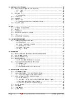
Summary of Contents for CP190i

Page 1: ......

Page 2: ...Owner s Manual CP190i GPS Chart Plotters CPF190i GPS Chart Plotters Fish Finder CPF190i CP190i ...

Page 3: ...tructionsmaycauseharmfulinterference with radio communications There is no guarantee that interference will not occur in a particular instance If this equipment does cause harmful interference to other equipment try to correct the problem by relocating the equipment Consult an authorized STANDARD HORIZON dealer or other qualified service technician if the problem cannot be corrected Operation is s...

Page 4: ... plotter screen is a very important operation and must be done carefully Since the surface is covered by a antireflective coating the procedure for cleaning all the surfaces can be performed using the following procedure Use a clean soft lint free cloth to clean the glass We recommend using a micro fiber cloth Spray a small amount of ammonia free cleaner isopropyl alcohol onto the cloth Spraying o...

Page 5: ...Page 6 CP190i and CPF190i ...

Page 6: ...F RADIO 25 2 8 CP190i OPTIONAL BLACK BOX FISH FINDER 25 2 9 RADAR ANTENNA USA ONLY 26 2 10 PERSONAL COMPUTER CONNECTIONS 26 2 11 NMEA DATA PAGE 27 2 12 DEMO MODE For DEALER USE 27 3 CONTROLS AND INDICATORS 29 3 0 CONTROLS AND CONNECTIONS 29 3 1 GETTING STARTED 30 3 1 0 Power On Off and ShuttlePoint Knob operation 30 3 1 1 Cursor Vs Home Mode 32 3 1 2 Cursor and Menu selection speed 32 3 1 3 Changi...

Page 7: ...ents Prediction 60 6 0 8 Chart Language 61 6 0 9 Pictures or Diagrams 61 How to show the Pictures or Diagrams of a Object 62 6 0 10 Enhanced Port Info 63 7 CREATING MARKS 65 7 0 CREATING A NEW MARK USING THE CHART PAGE 65 7 1 EDITING A MARK 65 7 1 0 Deleting a Mark or Waypoint 66 7 1 1 Moving a Mark or Waypoint 66 7 2 MARKS WAYPOINTS LIST 67 7 3 CREATING A NEW MARK WITH THE USER POINTS LIST 68 7 4...

Page 8: ... PAGES 87 12 0 CHART PAGE 87 12 0 0 Change Focus on Dual Chart Page 88 12 0 1 Single Chart Page 88 12 0 2 Window Selections 89 12 0 3 Customizing the Data Windows 89 12 0 4 Additional Functions on Chart Page 90 12 0 5 Turning Off Information on Icon Points 91 12 0 6 Display Mode 91 12 0 7 Marine Settings 92 12 0 8 Depth Settings 93 12 0 9 Land Settings 93 12 0 10 Chart Settings 93 12 0 11 Underwat...

Page 9: ...l Time View 116 15 0 4 Type of Data 116 16 MOBILARM 117 16 0 MOBILARM GPS CHART PLOTTER CONNECTION 117 16 1 SOFTWARE SETUP 118 16 2 MOBILARM STATUS 118 16 3 MOBILARM PTX 119 16 3 0 MOBILARM MOB alert is received 119 16 4 PLACING CURSOR ON THE PTX ICON 120 16 4 0 Delete PTX 120 16 4 1 Goto PTX 120 16 4 2 The MOBILARM Alarm Status List 121 17 FISH FINDER for CPF190i 123 17 0 ENABLE DISABLE 123 17 1 ...

Page 10: ...ater Speed 135 17 11 2 Calibrate Water Temp 135 17 11 3 Set Defaults 135 17 12 ALARMS 135 17 12 0 Shallow Water 136 17 12 1 Deep Water 136 17 12 2 Fish 136 17 12 3 Temperature Upper 136 17 12 4 Temperature Lower 136 17 12 5 Temperature Rate 136 17 13 SAVE SETTINGS TO USER C CARD 136 17 14 LOAD SETTINGS FROM USER C CARD 137 17 15 RESTORE CURRENT PRESET DEFAULTS 137 18 TROUBLESHOOTING 139 19 TECHNIC...

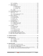
Page 11: ...Page 12 CP190i and CPF190i 21 APPENDIX TERMS 147 ANALYTICALINDEX 151 ...

Page 12: ...anced features of the GPS Chart Plotter Fish Finder include Built InChartsforcoastalnavigationofUSAincludingAlaska HawaiiandGreatLakes Canada Bahamas Caribbean Cuba Puerto Rico and Central America 5 320x232 high resolution sunlight readable display Internal 50 channel WAAS GPS antenna Optional connection for external 50 channels WAAS GPS antenna with 30 feet of cable Dual chart window with indepen...

Page 13: ...1 1 0 Packing List PART CODE ITEM S8002224A External bracket S8002225 Mounting knob with two washers S8002222 Dust cover T9101553 Power data cable S8002223 Flush mounting screws EM022U500 Flush mount template XUCMP0052 2 Amp fuse and holder EM050U100 Owner s Manual EM023U511 Quick Reference Guide 1 2 OPTIONAL DOME OR OPEN ARRAY RADAR ANTENNAS The Radar antennas are supplied by SI TEX 631 996 2690 ...

Page 14: ...h tempTransducer DST521 600WTransom mount depth speed tempTransducer DST523 600W 2 BronzeThru hull depth tempTransducer DST525 600W In hullTransducer DST526 600W 2 BronzeThru hull depth speed tempTransducer DST527 1000W In hull depthTransducer DST528A 1000W Bronze long stem depth tempTransducer ACCESSORIES ITEM PARTS NAME Dua l Freq uency Fish Find er CP190i ONLY FF525 ONLY FF525 ONLY ...

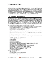
Page 15: ...Page 16 CP190i and CPF190i ...

Page 16: ... INTERNAL GPS RESTART GPS NAVIGATION SPEED NAVIGATION FILTER High DIFF CORRECTION SOURCE WAAS EGNOS Off On Figure 2 GPS Setup menu 5 Press CLR to exit the GPS SETUP menu 6 Confirm the GPS Status page is showing satellite signal strength bars and receive a fix 2 0 MOUNTING THE GPS CHART PLOTTER The CP190i and CPF190i are supplied with a swivel mounting bracket which allows them to be dash mounted W...

Page 17: ...P190i and CPF190i are supplied with a flush mount template for the cutout hole and screw holes required to install the GPS Chart Plotter NOTE Before drilling holes make sure there is enough room to mount the GPS Chart Plotter and there are no obstructions Figure 2 2 Example of Flush installation on CPF190i ...

Page 18: ...unsure of the chosen location temporarily mount the antenna in the desired location to verify correct operation If mounted close to Radar after the GPS Chart Plotter has a fix turn on the Radar to ensure the GPS Chart Plotter holds the fix use the GPS Status Page The thread used on the antenna is an industry standard 1inch 14TPI used on a wide range of mounting brackets NOTE The antenna cable can ...

Page 19: ...ttery Positive 2 Green Smart GPS NMEA Input 3 Brown Smart GPS NMEA Output 4 NC 5 NC 6 Black Yellow Battery Ground 2 4 CONNECTIONS The CP190i and CPF190i have connectors that allow them to be connected to a Power supply optional WAAS GPS antenna optional FF525 50 200kHz BLACK BOX FISH FINDER only for CP190i and NMEA Devices such as VHFs AIS Receiver Digital Instruments and autopilots NOTE RS232 not...

Page 20: ...W VHW and XTE sentences 6 Grey Port2 Input Connect to FF520 or FF525 Default is Fish Finder 7 White Port2 Output Connect to FF520 or FF525 Default is Fish Finder 8 Yellow Port3 Output Connect to Input of NMEA devices Default is NMEA0183 with APA APB BOD GGA GLL RMC and BOD sentences NOTE RS232 not opto isolated electrical interface NOTE AUTOPILOT CONNECTION Care must be taken when connecting the G...

Page 21: ...AIS Setup The CP190i has to be set up to be able to receive NMEA information from the AIS receiver The GPS Chart Plotter reads the AIS NMEA message VMD type 1 2 3 and 5 for AIS Class A and type 18 19 24 for AIS Class B Select the used port and transmission speed by following the procedure 1 Press MENU movetheShuttlePointknobtohighlight SETUPMENUandpress ENT 2 Move the ShuttlePoint knob to highligh...

Page 22: ...lt is NMEA0183 with APA APB BOD GGA GLL RMC and XTE sentences NOTE RS232 not opto isolated electrical interface NOTE AUTOPILOT CONNECTION Care must be taken when connecting the GPS Chart Plotter to an Autopilot Normally Port 3 Yellow wire will be used to connect to an Autopilot input however older autopilots may not be able to read the sentences due to the talker ID that is being used II Integrate...

Page 23: ...ssion speed by following the procedure 1 Press MENU movetheShuttlePointknobtohighlight SETUPMENUandpress ENT 2 Move the ShuttlePoint knob to highlight ADVANCED SETUP and press ENT or move the ShuttlePoint knob to the right 3 Move the ShuttlePoint knob to highlight IN OUT CONNECTIONS and press ENT or move the ShuttlePoint knob to the right 4 Move the ShuttlePoint knob to highlight PORT1 INPUT and p...

Page 24: ...ANDARD HORIZON VHFs STANDARD HORIZON has taken this feature one step further If a CP190i or CPF190i is connected to a DSC capable VHF the vessel in Distress or the polled position of the vessel is shown on the display of the GPS Chart Plotter making it easy to navigate to the location of the vessel This is a great feature that could save someone s life or for anyone wanting to know the position of...

Page 25: ...NMEA WPL and RTE sentences Refer to the table below for connection to a Serial DB9 connector Pin PC DB9 connection Port 1 connection 2 Receive Brown 3 Transmit Blue 5 Signal ground Green By default Port1 is set to receive or send User Points to and from a PC The GPS Chart Plotter may be set up to send and receive the User Points on a different Port using the following procedure 1 Press MENU move t...

Page 26: ...ighlight NMEA DISPLAY and press ENT 2 Move the ShuttlePoint knob to highlight DATA and press ENT 3 The NMEA DATA page is shown 4 Connect the Blue Wire on the GPS Chart Plotter to the junction of the Brown wire and the VHF wire The display should look similar to the following picture Figure 2 11 NMEA Data page 2 12 DEMO MODE FOR DEALER USE In Demonstration Mode the GPS Chart Plotter automatically p...

Page 27: ...nt knob to the right to show the popup window 5 Move the ShuttlePoint knob to select ON and press ENT or move the ShuttlePoint knob to the right 6 Demo mode is now activated Once the Demo Mode is enabled it is possible to temporally exit Demo Mode by pressing a key and return to the GPS Chart Plotter normal operation If a key in not touched for 30 seconds the Demo Mode will re start To disable the...

Page 28: ...hange the scale and show a wider otherwise less detailed view Pressing and holding ZOOM IN ZOOM OUT allows for quick zoom that is the fast change of the chart scale where only the land areas are drawn When ZOOM IN ZOOM OUT is released all chart details are shown NOTE The GPS Chart Plotter contains a Worldwide background that allows you to zoom in to 2NM For more detail a C MAP BY JEPPESEN NT MAX C...

Page 29: ...r automatically places a Mark on the Chart Page under the boat s position to aid in the rescue or a person that may have fallen aboard To stop navigating press GOTO select STOP and press ENT The FIND key A dedicated key that allows searching the optional C MAP BY JEPPESEN NT MAX C CARD for Port Services Ports Tide Stations Wrecks Obstructions Points Of Interest Lakes Information Lakes By Name User...

Page 30: ...Jeppesen charts 2 have read the documentation for this product including its notes and the Jeppesen Data License Agreement and agree to be bound by the terms of the Jeppesen Data License Agreement WARNING This product contains a limited set of built in C MAP by Jeppesen Charts Contact your dealer or Jeppesen for upgrade options Register with Jeppesen to receive regular product safety information P...

Page 31: ...s on the chart In this mode you can also create Marks Routes measure distance and bearings from your current position Home Mode When the ship icon is shown on the Chart Page cursor is not shown you are in Home Mode Now as the ship moves through the water the vessel s position will be kept in the center of the display NOTE To change from Cursor Mode to Home Mode press CLR 3 1 2 Cursor and Menu sele...

Page 32: ...ove the ShuttlePoint knob to the right 3 Move the ShuttlePoint knob to highlight SHIP ICON and press ENT or move the ShuttlePoint knob to the right to show the popup window with ship icons 4 Move the ShuttlePoint knob to select the desired icon and press ENT or move the ShuttlePoint knob to the right to select a new icon 5 Press CLR or move the ShuttlePoint knob to the left to exit the menu and sh...

Page 33: ...int knob to the right 5 Press CLR or move the ShuttlePoint knob to the left to exit the menu and show the Chart page NOTE When the CP190i and CPF190i are in Course Up mode a small arrow icon will be shown on the Chart page indicating North 3 2 AUTOMATIC TIME The time information supplied by the GPS satellites is in Universal Time Coordinates UTC or Greenwich England Mean Time To change the GPS Cha...

Page 34: ... ShuttlePoint knob to the right 5 Look at the table and find the time zone for your area Move the ShuttlePoint knob up or down to select the desired zone and press ENT 6 Next move the ShuttlePoint knob to highlight DAYLIGHT SAVING and press ENT or move the ShuttlePoint knob to the right 7 Daylight Saving menu has 3 options 7 1 OFF Select Off when your location does not recognize Daylight Savings T...

Page 35: ... Example Y Z change to Z Y 3 4 CHANGING THE CHART COLOR The CP190i and CPF190i have preprogrammed settings allowing you to customize the look of the Chart page The default is Sunlight however there are other settings Classic NOAA Night and Normal Night is very useful during evening hours so not to impair night vision Figure 3 4 Display Color menu 1 Press MENU move the ShuttlePoint knob to highligh...

Page 36: ...ENT or move the ShuttlePoint knob to the right 3 Move the ShuttlePoint knob to highlight LANGUAGE and press ENT or move the ShuttlePoint knob to the right 4 Another popup window will be shown with the available languages move the Shuttle Point knob to the desired language and press ENT or move the ShuttlePoint knob to the right 5 Press CLR or move the ShuttlePoint knob to the left to exit the menu...

Page 37: ...sible to ones used in the original paper charts Classic uses vivid chart colors presentation NOAA allows setting NOAA paper chart colors presentation Night is recommended when the environment is dark in order to reduce the glare of the display The GPS Chart Plotter displays charts and screen in darker colors SunLight default is designed to enhance the visibility of the screen when the GPS Chart Pl...

Page 38: ...zed so it is centered in the middle if Center selected or centered on the bottom of the Chart page if Bottom selected default COG TIME LINE It is a line projected from the ship icon which indicates the distance your vessel will travel at the current speed Selections are 2 10 default 30 minutes 1 2 hours and infinite NOTE TheavailableUnitsofMeasureforDistanceare Nm Sm Km Nm Ft Nm m Notewhen Nm Ft i...

Page 39: ...1 3 Storage Capacity XXXXXX YY YY INTCHART 1 WW M012 03 MARINE FRESHWATER WWBK BUILT IN CHARTS NA Z010 00 M NA M632 00 L ANGELES and S PEDRO BAYS 3 Designed for 2 1 Figure 3 7 Example of About page 4 Press CLR or move the ShuttlePoint knob to the left to exit and show the Chart Page ...

Page 40: ...ght PORT SERVICES and press ENT or move the ShuttlePoint knob to the right 3 A popup window will be shown with a list of different Port Services The table below shows a list of the available Port Services Figure 4 0 0 Port Services Table 4 Move the ShuttlePoint knob to highlight the desired type of service and press ENT 5 Another popup window will appear displaying the distance and position of the...

Page 41: ...CLR to show the actual position of the Port on the Chart Page 7 Press CLR again at any time to return your cursor to your vessel s position WAAS 3D Figure 4 0 1 Find Port 4 0 2 Tide Stations This feature is used to locate the 10 nearest Tide Stations to the position of your vessel Once a Tide Station is selected the Tide Graph can be used to determine Tide height and draught of the Tide based on a...

Page 42: ...intheTideGraph 1 MovingtheShuttlePointknobtotheleftorrightchanges the time and moving the ShuttlePoint knob up or down selects the Tide height and Tide draught on the Tide Graph NOTE The Local Offset matchs the Time Offset entered in the Time Setup menu see Par 3 2 4 0 3 Wrecks This feature is used to locate the 10 nearest Wrecks to the position of your vessel A Wreck is represented with an icon o...

Page 43: ...structions to the position of your vessel An Obstruction is represented with an icon on the chart see the following table snag stump wellhead diffuser crib fish haven foul ground ice boom ground tackle foul area ICON DESCRIPTION F o u l Obstn 46 Obstn Wk Mast 1 2 Figure 4 0 4 Obstruction icons Table 1 Press FIND 2 Move the ShuttlePoint knob to highlight OBSTRUCTIONS and press ENT or move the Shutt...

Page 44: ...nob to the right 3 A popup window will be shown with a list of Outdoor Recreational Area objects 4 Move the ShuttlePoint knob to highlight the desired object and press ENT 5 Another popup window will appear displaying the distance and position of the Lakes closest to your location 6 Using the ShuttlePoint knob highlight the desired Lake and press ENT This will show information on the Lake 7 Press ...

Page 45: ...ick Info available services If you press ENT all available information about the cartographic point under the cursor will be shown See the next paragraph 4 0 5 1 Full Info On Lakes The following is an example of Full Info on Lakes Figure 4 0 5 1 Example of Full Info page To see the Fishing object press MENU when the Fishing object is highlighted On the screen appears ...

Page 46: ...l appear displaying the distance and position of the Lake 5 Press ENT to show the actual position of the Lake on the Chart Page 6 Press CLR twice to return your cursor to your vessel s position 4 0 7 Points Of Interest This feature is used to locate Points Of Interest nearest the position of your vessel 1 Press FIND 2 Move the ShuttlePoint knob to highlight POINTS OF INTEREST and press ENT or move...

Page 47: ...e the ShuttlePoint knob to highlight USER POINTS and press ENT or move the ShuttlePoint knob to the right 3 The Select Name popup window will appear This window will allow you to enter in the name of the User Point you wish to locate 4 Move the ShuttlePoint knob up down to change each number or letter and left right to move to the next or previous position in the name of the Mark 5 Once the name o...

Page 48: ...n your cursor to your vessel s position WAAS 3D INFORMATION Figure 4 0 9 Find GPS Coordinates 4 0 10 Information This feature allows you to obtain information on any position on the Chart page 1 Press FIND 2 Move the ShuttlePoint knob to highlight INFORMATION and press ENT or move the ShuttlePoint knob to the right 3 A page will be shown with objects information The upper side of the page contains...

Page 49: ...Page 50 CP190i and CPF190i ...

Page 50: ...arts and 33 feet 10 meters on higher scale charts b All nav aids with icon c Tidal diamond symbols on Chart Page 1 Marina symbol with name and the list of services symbols 5 0 1 Updating Built In Charts The Built In Charts can be updated by purchasing a Chart Update Card from your local marine electronics dealer or C MAP USA at 800 424 2627 This Chart Update Card may be used ONE time to update the...

Page 51: ...he charts were not updated correctly follow steps 1 4 again If the GPS ChartPlottershowsaerrormessageagain contactC MAPUSAat 800 424 2627forassistance 5 1 INSERTING THE OPTIONAL MAX C CARD Hold the C CARD by the long inclined side so that you can see the C MAP BY JEPPESEN label Figure 5 1 Inserting C CARD Open the door gently push the C CARD into the slot push the C CARD in as far as it will go th...

Page 52: ... in ports and surrounding areas Object Info moving cursor over object to show restricted area details and related information Quick Info moving cursor over wrecks shoals Nav Aids to show restricted area details and related information and object to show details Photos Diagrams high definition pictures of ports piers bridge diagrams and nav aids Multilanguage Support allows the plotter to show lang...

Page 53: ...cts along your navigation route MAX and NT NT C CARD coexistence When NT data and MAX data cover different areas the GPS Chart Plotter receives data from both charts depending on the current position When NT data and MAX data cover the same area the GPS Chart Plotter receives data only from MAX chart ...

Page 54: ...u is described in the following 6 0 0 Zoom Type Zoom Type refers to the chart scale selection It has two options Standard default or Flexi Zoom When Zoom Type is set to Flexi Zoom a short ZOOM IN ZOOM OUT push causes a change of chart level while a long ZOOMIN ZOOMOUT push press and hold causes an expansion or compression of the chart image without a chart level change LONG PUSH SHORT PUSH ACQUIRI...

Page 55: ...til the menu disappears or an easier method is to move the ShuttlePoint knob to the left a few times 6 0 1 Icon Size On MAX charts it is possible to set the size of all icons drawn on the charts selecting between Standard default and Large size ICONS SIZE standard ICONS SIZE large Figure 6 0 1 Icons Size To activate this function follow the procedure 1 Press MENU move the ShuttlePoint knob to high...

Page 56: ...l mode during navigation Perspective view of the chart is a type of bird s eye view of a chart and give you a more realistic perspective of the chart As the upper side of the chart is more compressed than the lower side a wider chart area is visible so it allows showing more chart information immediately ahead and around the cursor Perspective View ON Perspective View OFF Figure 6 0 3 Perspective ...

Page 57: ...rning or alarm condition is identified by the red color to indicate possible risk To activate this function follow the procedure 1 Press MENU move the ShuttlePoint knob to highlight SETUP MENU and press ENT 2 Move the ShuttlePoint knob to highlight MAX FUNCTIONS and press ENT or move the ShuttlePoint knob to the right 3 Move the ShuttlePoint knob to highlight SAFETY STATUS BAR and press ENT or mov...

Page 58: ...ies Pingos and Production installations Red when Guardian Technology detects cautionary or restricted area Safety Status Bar O ZOOM DANGERS CAUTIONS BEST MAP DATA OFF DECLUT Figure 6 0 5 Safety Status Bar 6 0 6 Satellite Imagery This function allows to overlay the Satellite image for background chart When it is set On the Palette is set to Normal to display the proper colors NOTE The satellite ima...

Page 59: ... 2 0 kn 2 1 to 3 0 kn 3 1 to 9 9 kn Yellow Yellow Orange Orange Red Figure 6 0 7a Tidal stream arrows table When the GPS Chart Plotter receives a valid position fix the Tide icons are shown on the charts on the basis of the current date and time the screen displays and changes arrows as date time changes It is possible to see the variation of the Tidal arrows on the selected area at any given time...

Page 60: ...n the Language menu above If the selected language is not present on the objects information English is used English Always uses English Local Uses the Local language present on C MAP BY JEPPESEN C CARD If no Local language is available English is used 4 After the selection is made press CLR repeatedly or move the ShuttlePoint knob to the left repeatedly until the Chart Page is shown NOTE a Whenth...

Page 61: ...e object and there is the camera icon on the top bar of the window WAAS 3D Figure 6 0 9b Example of Quick Info on camera icon Press ENT for 1 second to display the image on the screen Figure 6 0 9c Example of displayed image Otherwise press ENT to open the Full Info on the object Note that on the Full Info there is the small camera icon on a corner of the square containing the object icon To see t...

Page 62: ...ny by moving the ShuttlePoint knob left or right 6 0 10 Enhanced Port Info Optional C MAP BY JEPPESEN MAX C CARDs include additional Port Services that were not present before Additional attributes of Port Areas and Port Marinas have been included as Location Country Region State Harbour master telephone number etc see the following figure PORT icon 1 1 WAAS 3D Figure 6 0 10 Example of enhanced Po...

Page 63: ...Page 64 CP190i and CPF190i ...

Page 64: ... 2 You will notice a Mark is placed under the location of the Cursor and a popup window is shown with the exact Lat Lon of the Mark 3 If the position is incorrect press ENT select EDIT using the ShuttlePoint knob and press ENT it will allow you to change the position Mark name and icon type Refer to Par 7 1 for details Vessel location Mark placed under Cursor Lat Lon of Mark DST BRG from vessel lo...

Page 65: ...ove the ShuttlePoint knob up or down to select the first character 10 Move the ShuttlePoint knob to the right to select the next character 11 Repeat steps 9 and 10 until the desired position is shown Press ENT and CLR to store the Mark 7 1 0 Deleting a Mark or Waypoint 1 Move the ShuttlePoint knob over the Mark or Waypoint to delete 2 Press ENT move the ShuttlePoint knob to highlight DELETE and pr...

Page 66: ...Waypoint NEW MARK Allows you to create and edit a new Mark Useful when entering man y Marks from a list MODE This selection controls how the Marks or Waypoints are shown on the Chart page Selections are a SHOW icon and name are shown b ICON only icon no name is shown c HIDE Mark or Waypoint is hidden d SHOW ALL All Marks or Waypoints are shown e ICON ALL All Icons are shown without name f HIDE ALL...

Page 67: ...nge the icon 6 Move the ShuttlePoint knob to highlight the desired Icon and press ENT 7 Move the ShuttlePoint knob to the right to select the Mark name Press ENT and the first digit in the name will be highlighted 8 Move the ShuttlePoint knob up or down to select the first character 9 Move the ShuttlePoint knob to the right to select the next character 10 Repeat steps 8 and 9 until the Mark name i...

Page 68: ... 1 Move the ShuttlePoint knob to the exact position you want to navigate to 2 Press GOTO and a GOTO popup window will be shown Figure 7 4 GOTO menu 1 3 Move the ShuttlePoint knob to highlight CURSOR and press ENT Figure 7 4a GOTO menu 2 4 The GPS Chart Plotter is now navigating from your current position to the location selected at step 1 A bearing line between the vessels location and the destina...

Page 69: ...nd press GOTO For more information about Routes refer to Section 9 GOTO MARK 1 Move the ShuttlePoint knob to an open position no buoy warning etc under the cursor on the Chart page 2 Press GOTO to show the GOTO popup window 3 Move the ShuttlePoint knob to highlight MARK and press ENT to show the MARKS WAYPOINTS List 4 Move the ShuttlePoint Knob to the highlight the desired Mark or Waypoint and pre...

Page 70: ...ING A MOB POINT 1 On the Chart page press MOB to start navigating back to the point 2 You will notice a MOB Mark will be on the Chart page and all navigation is referring back to this point 3 To stop navigating to the MOB point press GOTO select STOP and press ENT Figure 8 0 MOB point 8 1 DELETING A MOB POINT 1 Move the ShuttlePoint knob until the cursor is over the top of the MOB icon 2 Press ENT...

Page 71: ...Page 72 CP190i and CPF190i ...

Page 72: ...icular of the NAVIGATION LINE the Destination is moved to then next Waypoint in the Route WPT001 Destination Figure 9 Example to show how the plotter switches from one Waypoint to another 9 0 CREATING A ROUTE USING WAYPOINTS 1 On the Chart Page move the ShuttlePoint knob to the Lat Lon of the Starting Waypoint in the Route 2 Press ROUTE you will notice the Starting Waypoint will be placed under th...

Page 73: ...b up down to change the characters and left right to select a different character in the Route s Name EDIT ROUTE Figure 9 1 Edit Route Route Report 6 When finished press ENT to save 7 Press CLR to show the Chart Page 9 2 CREATING AN OLYMPIC ROUTE This feature allows the starting point in a Route to be saved as the final destination point 1 On the Chart page move the ShuttlePoint knob to the Lat Lo...

Page 74: ...ePoint knob to highlight SELECT and press ENT or move the ShuttlePoint knob to the right 4 Move the ShuttlePoint knob to an open Route number example Route 2 5 Press ENT or move the ShuttlePoint knob to the right 6 Press CLR or move the ShuttlePoint knob to the left until the Chart Page is shown 7 To create the new Route follow the steps in Creating a Route using Waypoints or Marks sections 9 4 CR...

Page 75: ...the right A popup window will be shown 9 Move the ShuttlePoint knob up down to change the characters and left right to select a different character in the Routes Name 10 When finished press ENT to save 11 Press CLR to show the Chart Page is shown 9 5 INSERTING A WAYPOINT INTO A ROUTE Place the cursor on the navigation line between two Waypoints and press ROUTE The line between the two Waypoints is...

Page 76: ...ve the ShuttlePoint knob to the highlight the desired Route and press ENT 6 OntheChartpageacirclewithaflagisshownonthefirstlegoftheRouteandanavigation line is shown indicating the GPS Chart Plotter is navigating to the first Waypoint in the Route Figure 9 6 0a GOTO ROUTE procedure 2 9 6 1 Using the ShuttlePoint knob 1 On the Chart page move the ShuttlePoint knob until the cursor reaches the starti...

Page 77: ...capable of sending NMEA RTE sentence THICKNESS Selection that allows the Route line to be easily seen default selection is Thick 9 8 0 Route Check The Route Check function is used after you have created a Route to ensure you and your vessel will not have problems while navigating This is done by the CP190i and CPF190i by reviewing the Route and looking for the following hazards that may effect saf...

Page 78: ...IT This selection allows you to select the water depth in the Route width area so the GPS Chart Plotter can check and confirm underwater threats It checks if some objects with the depth attribute like Shallow Water Dredged Areas Diffusers Obstructions Pingos Production Installation and Wrecks are above this depth level Only if the depth attribute is above the depth limit are they found and conside...

Page 79: ... be activated when the navigation is set to a single point like DSC MOB Mark In the case of checking a single point towards which the navigationisstarted thelegforwhichtheRouteCheckisexecutedisdefinedbythecurrentposition the leg s starting point and the destination point the leg s ending point ...

Page 80: ...ess MENU move the ShuttlePoint knob to highlight USER POINTS and press ENT 2 Move the ShuttlePoint knob to highlight TRACK and press ENT 3 Move the ShuttlePoint knob to highlight STEP UNIT and press ENT or move the ShuttlePoint knob to the right 4 Move the ShuttlePoint knob to highlight Dist or Time and press ENT or move the ShuttlePoint knob to the right Figure 10 Distance Units and Time Units 5 ...

Page 81: ... 1 Deleting a Track To delete a Track 1 Press MENU move the ShuttlePoint knob to highlight USER POINTS and press ENT 2 Move the ShuttlePoint knob to highlight TRACK and press ENT 3 Move the ShuttlePoint knob to highlight DELETE and press ENT or move the ShuttlePoint knob to the right 4 A warning popup window will be shown to confirm if you want to reset the Track Move the ShuttlePoint knob to high...

Page 82: ...b to select the desired units of measure and press ENT or move the ShuttlePoint knob to the right 4 Press CLR or move the ShuttlePoint knob to the right until the selected page Chart Navigation Highway or NMEA Data Page is shown 10 1 1 Setup Reset When Trip Log is selected in one of the data windows and you want to reset the log 1 Press and hold MENU until a field is highlighted it will be shown i...

Page 83: ...Page 84 CP190i and CPF190i ...

Page 84: ...C CARD 1 2 3 4 5 6 Type of data contained in the file Mark file Waypoint file File name Number of Selected file Information on stored User Points on Internal Memory Time of file creation Date of file creation 4 5 2 1 3 6 Figure 11 0 User C CARD Menu 11 0 0 Formatting the optional User C CARD 1 Press MENU move the ShuttlePoint knob to highlight USER POINTS and press ENT 2 Move the ShuttlePoint knob...

Page 85: ...ile from the User C CARD list by using the ShuttlePoint knob and press ENT 4 Move the ShuttlePoint knob to the left to highlight LOAD and press ENT 5 A popup information window will appear when loading is complete 6 Press ENT to confirm 11 0 3 Deleting a file from the optional User C CARD You may want to delete a saved file on the User C CARD 1 Press MENU move the ShuttlePoint knob to highlight US...

Page 86: ...the GPS Chart Plotter From this page the user can zoom in out pan around the chart show information about cartographic objects see the exact vessel position with the COG and SOG place points GOTO a destination point show Track history etc The GPS Chart Plotter come with Built In Charts for coastal navigation of USA including Alaska Hawaii and Great Lakes Canada Bahamas Caribbean Cuba Puerto Rico a...

Page 87: ...knob is moved the cursor on chart window will move The focus may be changed to to the other chart window with the procedure below 1 Press and hold FIND for 2 seconds The red boarder around the window is moved from active window to the other Repeat the step 1 to move the focus from a window to another 12 0 1 Single Chart Page WAAS 3D Course Over Ground 4 2 Time 1 3 Chart Scale 7 4 3 2 1 5 6 7 5 6 D...

Page 88: ...he right 4 Move the ShuttlePoint knob to highlight CHART PAGE and press ENT or move the ShuttlePoint knob to the right 5 Select the desired window HIGHWAY or COMPASS and press ENT or move the ShuttlePoint knob to the right 6 Press CLR or move the ShuttlePoint knob to exit the menu and show the Chart Page 12 0 3 Customizing the Data Windows ThedatafieldscontainedontheGeneral 1LineSmall Largeand2Lin...

Page 89: ...d it will be shown in a yellow frame 2 Move the ShuttlePoint knob to the desired data field the yellow frame is moved to the desired data field and press ENT The popup window will be shown 3 MovetheShuttlePointknobup downorleft righttochoosethedesiredsettingandpress ENT 4 Press CLR to store and exit the editing mode NOTE Data window field on the NAVIGATION HIGHWAY GPS STATUS and NMEA pages may be ...

Page 90: ...12 0 6 Display Mode Selects from a pre defined table what cartographic objects are displayed and which display options are set Pre programmed settings are user selectable from Full Medium Low Radar reduces the information on the display to simulate items that would be shown on a RADAR display Please note this function is not actually showing RADAR information it is only showing what typically woul...

Page 91: ...rt objects that either includes the Name of the chart object or the Depth of an Underwater chart object On or Off Nav Aids Light Sectors Turns the presentation of Lights Signals Buoys and Beacons On Nav Aids Light Sectors are shown Off Nav Aids Light Sectors are not shown or No Sector Nav Aids are shown Light Sectors are hidden Attention Areas Turns the Attention Areas areas in which special atten...

Page 92: ...ic Lines and Depth Area 0 1000 Ft 50 100 Ft Figure 12 0 8 Depth Settings 12 0 9 Land Settings To control the display on the map of the terrestrial features Land Elevations Turns the Land Elevations On or Off Land Elevation Values Turns the Land Elevation Values On or Off Roads Turns the Roads On or Off Points Of Interest Turns the Points of Information On or Off ROAD 1 1 2 POINT OF INTEREST LIBRAR...

Page 93: ...ny cartographic objects and it can be distinguished from the official chart objects from the Quick Info A dedicated icon is shown on the Quick Info window to indicate that the object queried isaVAD ThesameiconisalsoshownontheFullInfopageandinadditiontheextendedtextValue Added Data is shown on the details of the VAD object See the figure below Example of VAD object 1 1 Chart Lock Turns the chart fu...

Page 94: ...electedfrom Underwater ObjectDepthValue option ICON DEPTH theobjecticonandtagisvisible intherangeselected from Underwater Object Depth Value option 12 1 CUSTOMIZING CHART SETTINGS The GPS Chart Plotter also allows you to customize items shown on the chart discussed inabovesections insteadofusingapre definedtablediscussedinPar 12 0 4DisplayMode 1 Press MENU move the ShuttlePoint knob to highlight S...

Page 95: ... Time 1 3 Speed Over Ground Course Over Ground 5 1 3 4 2 8 WAAS 3D 5 Time To Go 6 6 7 Distance to Destination 7 Compass Rose 8 Figure 12 2 Navigation page with Compass Rose WAAS 3D Time To Go 4 Fix position 2 7 Compass Tape Time 1 6 3 8 Speed Over Ground Course Over Ground Bearing to Destination 5 1 3 4 2 5 6 8 7 Distance to Destination Figure 12 2a Navigation page with Compass Tape NOTE The COG h...

Page 96: ...n changes the digits and left and right selects the month day and year 3 Press CLR to exit and view the information WAAS 3D 1 2 3 Figure 12 4 Celestial page Refer to the image above The time 1 displayed corresponds to the location of the cross haircursor 3 intheTideGraph 2 MovingtheShuttlePointknobtotheleftorrightchanges the time moving the ShuttlePoint knob up or down selects the Tide height and ...

Page 97: ... Course Over Ground 7 D C E A B 7 14 20 25 31 28 Figure 12 5 GPS Status page The WAAS GPS Icon area may change due to the satellite reception ACQUIRING the GPS is trying to receive a valid position fix GPS2D The GPS is receiving at least 2 valid Satellites GPS3D the GPS is receiving at least 3 Satellites WAAS 2D 3D the GPS is receiving a 2D or 3D position and the correction from the WAAS Satellite...

Page 98: ... setting is Off Differential Correction Source Allows setting what kind of Differential Correction will be used by the GPS between WAAS EGNOS and none The default setting is WAAS EGNOS 3 Move the ShuttlePoint knob to highlight the preferred item and press ENT 4 Press CLR until the menu disappears or an easier method is to move the ShuttlePoint knob to the left until the menu disappears 12 6 NMEA D...

Page 99: ...can also be used to see if the GPS Chart Plotter NMEA output is being loaded down by a external NMEA device the GPS Chart Plotter is connected to Scenario VHF Radio connected but the Radio is not receiving a GPS Position Usually the VHF Radio will be connected to the Green and Brown wires To check to see if the GPS Chart Plotter is transmitting the sentences 1 Press MENU move the ShuttlePoint knob...

Page 100: ...ed DST521 or DST526 must be connected to show speed through the water when a Standard Horizon transducer is connected To show Wind trend information the CP190i and CPF190i must be connected to the NMEA output of a external Wind instrument NOTE The CP190i must be connected to the Optional FF525 or FF520 50 200kHz BLACK BOX FISH FINDER To select a NMEA Trend Page 1 Press MENU move the ShuttlePoint k...

Page 101: ...e Radios with Digital Selective Calling are able to be interfaced with the GPS Chart Plotter which feeds GPS data to the VHF and listens for DSC calls from the VHF By connecting a few wires between the compatible DSC VHF radios and the GPS Chart Plotter it will receive 1 a vessel that has transmitted a DSC Distress call 2 a vessel that has transmitted a DSC Position Send Call 3 The position of a v...

Page 102: ...igure 12 9 1 DSC Log Distress Call 12 9 2 Position Request STANDARD HORIZON GPS chart plotters are able to display the location of a vessel when connected DSC VHF radio and when a Position Request or Report call is received STANDARD HORIZON GPS also log DSC Distress calls to review at a later date 1 Press MENU and move the ShuttlePoint knob to highlight USER POINTS and press ENT 2 Move the Shuttle...

Page 103: ...Page 104 CP190i and CPF190i ...

Page 104: ...d default setting Fish Finder Only for CP190i FF525 50 200kHz BLACK BOX FISH FINDER refer to Fish Finder Owner s Manual C COM C Weather refer to Section 15 Radar SI TEX optional Radar refer to Radar Owner s Manual AIS38400 AIS Receiver refer to Section 14 MOBILARM Mobil arm receiver refer to Section 16 Disabled allow the port to be disabled NOTE RS232 not opto isolated electrical interface NOTE Wh...

Page 105: ...em Loran TD s Chart Datum Chart Orientation Resolution angle the vessel has to change before the chart is redrawn and Static Navigation See the following table Coordinate System Selections are a TD Time Difference based on Loran see the following Par 13 1 0 b UTM Universal Transverse Mercator Grid c ddd mm mmm Degrees Minutes and Thousands of Minutes d ddd mm mm Degrees Minutes and Hundredths of M...

Page 106: ...ly the user does not enter a ASF value However for experienced users this function allows entering of signal delay values to fine adjust the calculated position The user should enter delay values to fine adjust the position calculated Alter Alternate Solution TD Coordinate System Parameter selected by the user that is applied in the conversion of geographical coordinates Lat Lon to TD values To be...

Page 107: ...ently detected Grounding Alarm Report This function allows displaying a report of the dangerous objects currently detected The following warning appears when the Grounding Alarm is enabled NOTES TheGroundingAlarmfunctionisavailableonlyifaNT MAXC CARDisinserted Italsoaffectsthe screen redraw speed so we suggest to disable it when not used When any of the objects checked are found for the first time...

Page 108: ...MODE and press ENT to show a popup window 6 Move the ShuttlePoint knob to highlight ROUTE and press ENT which will show a popup window with the Route s that are stored in the GPS Chart Plotter s memory 7 Highlight the desired Route and press ENT 8 Move the ShuttlePoint knob to highlight SPEED and press ENT 9 Enter in the speed you want to vessel to travel at in simulation mode by moving the Shuttl...

Page 109: ...Page 110 CP190i and CPF190i ...

Page 110: ... CPA Limit This is the distance from your vessel that a target may reach before a target is deemed a threat CPA Alarm Occurs if CPA is less or equal to CPA Limit This test is done for active targets only TCPA Time to closest Point of Approach is the time remaining until the CPA will occur TCPA Limit This is the time remaining before the CPA is reached TCPA Alarm Occurs if TCPA is less or equal to ...

Page 111: ...menu appears on the screen The available functions are described in the following table Display Turns the display of AIS Targets overlay on the cartography On or Off The default setting is On Activation Range Defines the range from the fix within which the AIS Target becomes active The values allowed are from 0 1 to 20 Nm The default setting is 5 Nm CPA Alarm Turns On or Off the alarm The default ...

Page 112: ...hip with the ability to select a Target ship and locate it on the chart Follow the procedure 1 Press MENU movetheShuttlePointknobtohighlightUSERPOINTSandpress ENT 2 Move the ShuttlePoint knob to highlight AIS LIST and press ENT Figure 14 4 AIS List page 3 Move the ShuttlePoint knob up or down to select the Target and scroll the page up or down Press ENTER exitsthepageandshowstheTargetshipontheChar...

Page 113: ...ESENTATION Undefined yellow Fishing white Pleasure Craft light green Tanker dark blue Pilot Vessel light gray SAR black Tug pale green Port tenders brown Vessels with antipollution facilities or equipment light blu Low enforcement vessels light red Medical transport dark green Vessels according to Resolution N 18 Mob 83 cyan HSC red Passenger ship magenta Cargo ship dark gray o Figure 14 5 Color A...

Page 114: ... 30 VISIBILITY 20 WEATHER TYPE Sun WEATHER TYPE Rain WEATHER TYPE Fog WEATHER TYPE Snow WEATHER TYPE Clouds WEATHER TYPE Partly Cloudy WEATHER TYPE Thunderstorm Data Type Display Figure 15 Weather data package 15 0 C WEATHER SERVICE MENU To select the menu 1 Press MENU move the ShuttlePoint knob to highlight SETUP MENUand press ENT 2 Move the ShuttlePoint knob to highlight C WEATHER SERVICE and pr...

Page 115: ...ARD 15 0 2 Weather Forecast Allows selecting the layer of specific weather data to be displayed on the screen and to change date and time of the forecast preview The following functions are available Panning default usage of the cursor key is the normal panning function Zoom in out zoom in out functions are allowed as usual by using ZOOM IN ZOOM OUT Set of date and time GOTO to modify date and tim...

Page 116: ... the vessels position is shown on the Standard Horizon GPS Chart Plotter 16 0 MOBILARM GPS CHART PLOTTER CONNECTION Connect the MOBILARM system to one of the Ports on the Standard Horizon GPS Chart Plotter Refer to Par 2 4 0 Connection Table for CP190i Par 2 4 2 Connection Table for CPF190i and MOBILARM Owner s Manuals for connections Connection Example Blue Brown Black Green Red PWR ACC 1 Cable T...

Page 117: ...N OUT CONNECTIONS and press ENT or move the ShuttlePoint knob to the right 5 Move the ShuttlePoint knob to highlight any input port and press ENT or move the ShuttlePoint knob to the right 6 Move the ShuttlePoint knob up down to select MOBILARM and press ENT or move the ShuttlePoint knob to the right Selecting MOBILARM format activates the function 7 Press CLR or move the ShuttlePoint knob to the ...

Page 118: ...ART 1 WW M012 03 MARINE FRESHWATER WWBK BUILT IN CHARTS NA Z010 00 M NA M632 00 L ANGELES and S PEDRO BAYS Designed for 1 Figure 16 2 Example of About page with MOBILARM information 16 3 MOBILARM PTX A PTX is the Personal Transponder device that is worn by the crew If a crew member falls in the water the MOBILARM sends a signal to the GPS Chart Plotter which creates and displays a PTX icon on the ...

Page 119: ... the ShuttlePoint knob so the cursor is over the PTX icon on the Chart page will show an information window and allow you to Goto the location of the PTX delete the PTX icon or show the Alarm Status list as shown below Figure 16 4 Example of PTX information window 16 4 0 Delete PTX The Delete PTX function permamently removes the selected PTX from the MOBILARM Alarm Status List and from the Chart P...

Page 120: ...e MOBILARM Alarm Status List The MOBILARM Alarm Status List shows the list of all PTX that the GPS Chart Plotter has received an alarm from To review the page 1 Select the Chart Page 2 Press MENU to show the Main menu 3 Move the ShuttlePoint knob to highlight USER POINTS and press ENT 4 Move the ShuttlePoint knob to highlight MOBILARM and press ENT 03 45 14 PM 10 31 24 PM 213 22 120W 305 04 015W 2...

Page 121: ...e selected PTX Once the navigation has been activated close all menus data pages if open and center the chart selected PTX DELETE Deletes the selected PTX SHOW Centers the chart on the selected PTX SHOW ALL Selects the best chart scale to see al PTX icons on the chart at the same time ...

Page 122: ...erted into a voltage and is amplified by the receiver processed and sent to the display The speed of sound in water is roughly 4800FT sec so the time lapse between the transmitted signal and the received echo can be measured and the distance to the object determined Figure 17 Fish Finder working principle 17 0 ENABLE DISABLE The internal Fish Finder may be enabled default setting or disabled by th...

Page 123: ...cription of terms listed in the previous Figure Warning Message Flashing label that is turned On when the echo sounder is in Simulation mode The following is the list of the warning messages see also Par 5 8 SHALLOW WATER DEEP WATER HIGH WATER TEMP LOW WATER TEMP WATER TEMP RATE FISH SPOT NO DATA Fish Finder window Graphic presentation of sonar soundings recorded as a continuous profile scrolling ...

Page 124: ... strongest sonar returns will be shown as red and weaker returns will be shown blue Deep Alarm Bar Bar located on the left side of the Range Bar showing the portion of the Echogram currently represented in the zoomed window on the left part of the screen It is turned On selecting the Echosounder Split page Transmit Frequency Shows the selected depth transmit frequency As a reference 200kHz selecti...

Page 125: ...bles bait fish plankton and algae Structures Generally the term structure is used to identify objects like wrecks and weeds rising from the bottom Bottom Echo Profile Bottom profile recorded by the Fish Finder When the echo sounder is set in Auto Range mode the bottom is kept in the lower half in the display 17 2 DISPLAYING THE FISH FINDER PAGE This section explains how to show and customize the s...

Page 126: ...GPS Chart Plotter display to show 200kHz 50kHz or 200 50 kHz split screen Fish Finder 200kHz 50kHz 50 200kHz Figure 17 2 1 Full Display pages 17 2 2 200 kHz and 50 kHz Zoom Pages Allows the user to zoom into the 200kHz or 50kHz Fish Finder display to show detail of the area selected by the VRM Variable Range Marker Referring to Figure 17 2 2 the left display shows the zoomed display and the right ...

Page 127: ...the Fish Finder window With the focus on the Chart Page the cursor may be moved and all chart menus can be selected When focus is on the Fish Finder window the Variable Range Marker can be moved to see the depths of targets and Fish Finder menus can be accessed 17 3 SETUP MENU This section explains how to show the Fish Finder Setup menu and describe the Fish Finder Setup menu sub options 1 From th...

Page 128: ...n On Surface Declutter 4 4 Figure 17 4 Presets table NOTE For Gain and Gain Offset settings refer to Sensitivity menu see Par 17 9 For Range and Shift settings refer to Range menu see Par 17 7 17 5 FREQUENCY Allows you to choose the frequency among Auto 50 kHz 200 kHz or 50 200 kHz when single frequency page is selected Figure 17 5 Frequency menu 17 6 GAIN MODE Figure 17 6 Gain Mode menu ...

Page 129: ...n In this mode Shift is always set to 0 17 7 0 2 Bottom Lock The Bottom Lock function keeps the screen display locked onto a certain Range around the bottom Let s say the bottom is 400FT and the Bottom Lock Range is set to display 30FT aroundthebottom thescreen insteadofdisplayingfrom0FTtoe g 450FT willdisplayonly a Range of 30FT around the bottom e g from 380FT to 410FT 17 7 1 Depth Moves the dis...

Page 130: ... may be near by when fishing 17 9 SENSITIVITY MENU All settings in the Sensitivity menu are related to the selected Fish Finder transmit frequency 50 or 200kHz Figure 17 9 Sensitivity menu 17 9 0 Gain Allows you to control the Sensitivity of the unit s receiver from 0 to 100 To see more detail increase the receiver Sensitivity by selecting a higher Gain percentage If there is too much detail or if...

Page 131: ...200 kHz frequency and MID for the 50 KHz frequency Such values are good in most conditions However when navigating in very shallow waters it may be necessary to switch it to OFF while in very deep waters with a lot of Surface Clutter it may be better to increase it to MID or LONG NOTE In some situations it may be necessary to adjust the STC so the sounder can read through the surface noise and sho...

Page 132: ...ttom In these cases change the RANGE MODE from AUTO to MANUAL Range and manually adjust the depth range until the bottom echo becomes visible on the Fish Finder display 17 9 2 Surface Noise Filter An automatic filter that attempts to dynamically remove Surface Clutter that causes the screen to be filled up with strong return echoes just below the surface It may seem that the same functionality cou...

Page 133: ...rolls and updates the Fish Finder display 17 10 2 White Line Controls how the bottom type hard or soft is shown on the display When the White Line is Off the bottom return will display as red When the White Line is On it can be used to determine bottom hardness 17 10 3 Fish Symbols Controls the graphical representation of underwater suspended targets Echo shown as arches echoes Icon Echo shown as ...

Page 134: ...Fish Finder to display an offset depth below the keel or the actual water depth from the surface To setup to show the depth below the keel enter a negative depth value or a positive depth to show offset from the transducers face to the water surface 17 11 1 Calibrate Water Speed Used to calibrate the Water Speed readings from the transducer Adjustment can be made from 10 to 10 17 11 2 Calibrate Wa...

Page 135: ...on the size of fish The options are Off Small Medium Big and Huge The alarm sounds if the set size or bigger is detected 17 12 3 Temperature Upper Triggers an alarm when the transducer reports a temperature above the set temperature 17 12 4 Temperature Lower Triggers an alarm when the transducer reports a temperature below the set temperature 17 12 5 Temperature Rate Triggers an alarm when the tra...

Page 136: ...et of Fish Finder settings from the User C CARD Memory Card that may be used to backup the User Points and Tracks too Figure 17 14 C CARD Load settings 17 15 RESTORE CURRENT PRESET DEFAULTS This option restores the default values only for the current presets and does not affect the other presets Figure 17 15 C Card Restore settings ...

Page 137: ...Page 138 CP190i and CPF190i ...

Page 138: ...ong exposure to direct sunlight The internal temperature is very high Protect the GPS Chart Plotter from direct sunlight The GPS Chart Plotter does not respond to any command The GPS Chart Plotter may be in an unpredictable status Try to turn Off and then turn On If the problem persists reset the RAM or remove power from the battery The location of my fix is not shown correctly on the Chart page P...

Page 139: ...Page 140 CP190i and CPF190i ...

Page 140: ...integrity of the memories and if desired during this test all the internal memory can be erased and the default setting restored RAM Clear To clear internal memory If the GPS Chart Plotter exhibits unusual operations or appears to be malfunctioning it may be possible to correct the problem by clearing RAM This operation will erase all Marks Routes stored Track plots and Destinations It will also r...

Page 141: ...ePort Signal Source between PORT 1 PORT 2 PORT 3 the Baud Rate between 300 1200 2400 4800 9600 38400 115200 the Data Bits Word Length between 7 or 8 the Parity between even odd or none the StopBits between 1 or 2 Default settings are Port PORT 2 Baud Rate 4800 Data Bits 8 Parity none Stop Bits 1 Input Data Display To allow the GPS Chart Plotter to act as a computer terminal and display the incomin...

Page 142: ...50 max 100 Waypoints each Track Points 10000 recordable in 20 Tracks NMEA Output sentences GLL VTG BWC WCV APA APB HTG BOD XTE RMA RMB RMC GGA HSC DBT DPT MTW VHW WPL RTE GSA GSV NMEA Input sentences BWC DSC DSE GGA GLL GSA GSV HDG HDM HDT RMC VHW VTG DPT DBT MTW VWR VWT TLL WPL RTE 20 1 CPF190i FISH FINDER SPECIFICATIONS Power Output 600W Frequency 50 and 200kHz Minimum Depth 5Feet at 50kHz 2 5Fe...

Page 143: ... OPTIONAL FF525 FISH FINDER SPECIFICATIONS USE WITH CP190i Power Output 600W or 1kW depending on connected transducer Frequency 50 and 200kHz Minimum Depth 5Feet at 50kHz 2 5Feet at 200kHz Maximum Depth 1500FT at 50kHz 700FT at 200kHz Airmar X DUCER ID Must use Standard Horizon transducers Advanced Digital Signal Processing Speed Temperature Sensor if available on transducer Alarms shallow water d...

Page 144: ... 97mm in diameter x 32mm in height flush mounted or 61 5mm on flag pole mount Weight without cable 0 35 lb 160 g Cable white 15 meter 8x28AWG cable with 6 pins female connector Electrical Characteristics Input Voltage 10 Vdc to 35 Vdc unregulated Input Current 0 8 Wmax GPS Receiver Sensitivity Tracking Navigation 160 dBm Acquisition Reacquisition 160 dBm Cold Starts 145 dBm GPS Performance GNSS Sy...

Page 145: ...Page 146 CP190i and CPF190i ...

Page 146: ...fely navigate On the Celestial page the draught window shows the height of the tidal water during a 24hr period of time This height is dependant on the time of day selected using the ShuttlePoint knob DSC Digital Selective Calling Digital Selective Calling is a semi automated method of establishing a VHF Radio call DSC had also been designated as part of the Global Maritime Distress and Safety Sys...

Page 147: ...To Go Shows time to go to reach a Destination point UNITS Nm Nautical Mile 1 NM 1 15 Sm or 1 85Km Sm Statue Mile 1Sm 0 87Nm or 1 61Km Km Kilometer 1 Kilometer 0062 Sm or 0 54Nm FT Feet 1 Foot 0 167 Fathoms or 0 305 Meters FA Fathom 1 Fathom 6 Feet or 1 83 Meters Mt Meter 1 Meter 3 28 Feet or 0 55 Fathoms Kts Knot 1 Knot 1 15 MPH or 1 85 KPH MPH Miles Per Hour 1 MPH 0 87 Knots or 1 61 KPH Kmh Kilom...

Page 148: ...i Page 149 WATER TEMP Shows the sea water temperature for when a Digital Speed Log Temp instrument with NMEA is connected XTE Cross Track Error The distance your vessel is off course left or right to a Destination point ...

Page 149: ...Page 150 CP190i and CPF190i ...

Page 150: ... APB 106 143 Apparent Wind Direction 89 147 Apparent Wind Speed 89 147 Arrival Alarm 108 ASF 36 ASF1 2 107 assistance 13 Attention Areas 92 Audible Alarm 108 Auto Full page 127 AUTO INFO 39 91 Auto Info 111 Auto Info settings 91 Auto Mode 130 Auto Position 109 Auto Range 130 AUTOMATIC CHECK 79 Automatic Route Check 79 AUTOMATIC TIME 34 Autopilot 20 22 24 25 AUTOPILOT CONNECTION 21 23 AWD 89 AWS 89...

Page 151: ...able 107 COMPASS TAPE 96 Compass Tape 95 96 confirm selection 29 Connect the MOBILARM 117 CONNECTIONS 20 Contrast 33 141 CONTROLS 29 conventions 17 29 Coordinate System 35 106 Coordinates 48 Copyright 4 Course 109 Course Over Ground 81 89 147 COURSE UP 38 Course Up 33 Coverage areas 51 CP190i Connection Table 21 CP190i Connections 21 CPA 111 112 CPA Alarm 111 112 CPA Limit 111 112 CPF190i Connecti...

Page 152: ...AY COLOR 38 Display Color 17 36 99 Display Mode 91 Display Mode settings 91 display of AIS Targets 112 Display Setup menu 134 DISTANCE 83 Distance 38 69 Distance to Destination 89 Distance Units and Time Units 81 Distress Call 102 Download Area 115 download weather data 115 DPT 99 106 143 DRAUGHT 147 draught 97 Dredged Areas 78 DSC 99 102 109 143 147 DSC Distress Call 102 DSC POLLING 109 DSC VHF R...

Page 153: ...ODE 129 General 89 German 37 GGA 99 106 143 GLL 99 105 106 143 GOTO 30 87 GOTO A ROUTE 77 GOTO CURSOR 69 GOTO MARK 70 GOTO menu 69 Goto PTX 120 GOTO ROUTE 70 GPS 99 GPS antenna 17 19 GPS Constellation 147 GPS Coordinates 30 GPS Receiver 17 145 GPS SETUP menu 98 GPS Setup Menu 99 GPS Status 90 GPS STATUS PAGE 98 GPS Status page 31 GPS2D 98 147 GPS3D 98 147 Great Lakes 13 51 87 Greek 37 Grounding Al...

Page 154: ...a file 86 LOCATE 67 locate Points Of Interest 47 locate Port 42 locate Port Services 41 locate Tide Stations 42 locate Wrecks 43 Longitude 35 48 Loop Back Test 142 Loran 35 Loran TD 107 LOW WATER 148 Low Water 98 LOW WATER TEMP 124 M Main Menu 29 87 126 MAN OVER BOARD 71 Manual Mode 130 Marine Settings 92 95 MARK 13 30 65 Mark 13 30 48 65 66 67 73 75 85 143 Mark editing 66 Mark Icons 66 MARKS WAYP...

Page 155: ...105 Over Zoom 56 P package 14 Packing List 14 PAGES 87 Pair 36 107 Palette 59 Parity 142 PC COM settings 26 PC Planner 115 PERSONAL COMPUTER 26 Personal Computer 25 Perspective View 53 57 Photos 53 Pictures 61 Pin 115 PINGO 148 Pingos 78 Place Name Size 56 Place Names 92 Places a Mark 30 places a Waypoint 30 PLACING A MOB 71 Points Of Interest 30 47 92 93 Port 42 142 Port Areas 65 Port Icons 90 Po...

Page 156: ...3 98 Satellite Imagery 59 satellite reception 98 SAVE 86 Save settings 137 SCALE 90 screen 5 139 screen display pages 87 Scrolling Speed 134 Seabed Type 92 Search 53 SELECT 78 Select Country To Call 115 SELECT ROUTE 77 select the language 37 SEND 67 78 Sensitivity menu 131 sentences 27 Serial Ports 142 Setup Reset 83 Setup Menu 99 Shallow Alarm Bar 125 SHALLOW WATER 124 Shallow Water 78 136 Shift ...

Page 157: ... 30 42 90 Tides Currents 92 Tides Preview 53 TIME 83 90 148 Time 81 109 Time Format 38 TIME SETUP 38 Time To Go 89 TLL 99 143 TLOG 83 90 Towers 90 Track 81 85 87 Track Points 81 143 Track points 13 TRACKING 81 82 90 Tracks Routes 92 93 transducer 14 101 Transducer Setup menu 135 Transferring files 85 Transmit Frequency 125 TRIP LOG 83 148 Trip Log 83 90 Trip Log Reset 83 TROUBLESHOOTING 139 True W...

Page 158: ...Warping Facility 78 Warranty 13 Water Resistance 143 water resistent 13 WATER TEMP 149 WATER TEMP RATE 124 Water Temperature 81 90 124 Waypoint 30 48 65 66 67 73 76 143 WCV 105 106 143 Weather data package 115 Weather Forecast 116 Weight 143 WGS84 106 White Line 126 134 Wind Instrument 25 WIND SPEED TREND 101 WINDOW SETUP 96 WINDOWS SETUP 38 89 WPL 27 67 68 99 143 Wreck icons Table 43 Wrecks 30 43...

Page 159: ...pt where purchaser abuse or other qualifying exceptions exist The purchaser must pay any transportation expenses incurred in returning the Product to STANDARD HORIZON for service This limited warranty does not extend to any Product which has been subjected to misuse neglect accident incorrect wiring by anyone other than STANDARD HORIZON improper installation or subjected to use in violation of ins...

Page 160: ......

Reviews: