background image


UniTraQ International Corp.


RoHS compliance   


2009, 04, Version 1.2                                                                                 

8

Eastern Star 5 series GT-525 

GPS Module

 
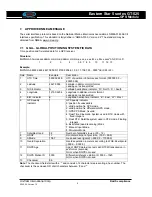
7.    APPROVED NMEA MESSAGE 

 
The serial interface protocol is based on the National Marine Electronics Association’s NMEA 0183 ASCII 
interface specification. This standard is fully define in “NMEA 0183, Version 2.2” The standard may be 
obtained from NMEA, www.nmea.org 


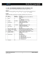
7.1    GGA – GLOBAL POSITIONING SYSTEM FIX DATA 

Time, position and fix related data for a GPS receiver.   
 

Structure: 

$GPGGA,hhmmss.sss,ddmm.mmmm,a,dddmm.mmmm,a,x,xx,x.x,x.x,M,x.x,M,x.x,xxxx*hh<CR><LF> 

1               2              3            4             5 6   7   8    9       10       11   12    13  


Example:  

$GPGGA,060932.448,2447.0959,N,12100.5204,E,1,08,1.1,108.7,M,,,,0000*0E<CR><LF> 
 
Field Name 

Example 

Description 

UTC Time 

060932.448 

UTC of position in hhmmss.sss format, (000000.00 ~ 
235959.99) 

Latitude 

2447.0959 

Latitude in ddmm.mmmm format 
Leading zeros transmitted 

N/S Indicator 

Latitude hemisphere indicator, ‘N’ = North, ‘S’ = South 

Longitude 

12100.5204 

Longitude in dddmm.mmmm format 
Leading zeros transmitted 

E/W Indicator 

Longitude hemisphere indicator, 'E' = East, 'W' = West 

6 GPS 

quality 

indicator 
 

GPS quality indicator 
0: position fix unavailable 
1: valid position fix, SPS mode   
2: valid position fix, differential GPS mode 
3: GPS PPS Mode, fix valid 
4: Real Time Kinematic. System used in RTK mode with 

fixed integers 

5: Float RTK. Satellite system used in RTK mode. Floating 

integers 

6: Estimated (dead reckoning) Mode 
7: Manual Input Mode 
8: Simulator Mode 

Satellites Used 

08 

Number of satellites in use, (00 ~ 12) 

8 HDOP 

1.1 

Horizontal 

dilution 

of precision, (00.0 ~ 99.9) 

Altitude 

108.7 

mean sea level (geoid), (-9999.9 ~ 17999.9) 

10 

Geoid Separation 


Geoid separation in meters according to WGS-84 ellipsoid 
(-999.9 ~ 9999.9) 

11 

DGPS Age 


Age of DGPS data since last valid RTCM transmission in 
xxx format (seconds) 
NULL when DGPS not used 

12 

DGPS Station ID 

0000 

Differential reference station ID, 0000 ~ 1023 
NULL when DGPS not used 

13 Checksum 

0E 


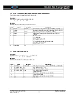
Note:

 The checksum field starts with a ‘*’ and consists of 2 characters representing a hex number. The 

checksum is the exclusive OR of all characters between ‘$’ and ‘*’. 


Summary of Contents for GT-525

Page 1: ...GPS Module Series Model GT 525 Flash version UniTraQ International Corp All right reserved 2009 2F No 136 Ziqiang S Rd Zhubei City Hsinchu County 30264 Taiwan R O C TEL 886 3 6578491 FAX 886 3 657849...

Page 2: ...Corp RoHS compliance 2009 04 Version 1 2 Version History Date Version Description of change Author 2008 09 12 0 1 Original Victor 2009 01 21 1 1 Enhance Warm start performance Victor 2009 04 06 1 2 Ch...

Page 3: ...specification 4 3 Communication specification 5 4 Connector 5 5 On board patch antenna 6 6 Mechanic dimension 7 7 Approved NMEA message 8 7 1 GGA global positioning system fix data 8 7 2 GLL latitude...

Page 4: ...5 Fast Acquisition High Sensitivity 20 Channel GPS Receiver Module The GT 525 is a compact all in one GPS module solution intended for a broad range of Original Equipment Manufacturer OEM products whe...

Page 5: ...tart sensitivity 142dBm Receiver frequency 1575 42MHz Code C A code Accuracy 1 Horizontal 2 Velocity 10 meters 2D RMS 7 meters 2D RMS WAAS corrected 0 1m sec Startup Time hot start warm start cold sta...

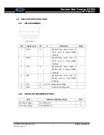
Page 6: ...output NMEA message 2 FRX0 I Asynchronous serial Input at LVTTL level to Input NMEA message 3 TX0 O Asynchronous serial output at RS 232 level to output NMEA message 4 RX0 I Asynchronous serial Input...

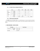
Page 7: ...V RX0 Input L Voltage 0 0 4 V Voltage 3 0 5 0 5 5 V VCC Current 40mA 46mA mA 5 0V 2 2 4 GPS STATUS INDICATOR The GT 525 provides GPS status indicator On board LED shows fix or non fix In fix mode the...

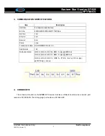
Page 8: ...it Stop bit 1bit Data bit 8bit Parity none Transmission data SACII NMEA0183 Ver 2 2 Update rate 1Hz GGA 1s GSA 1s GSV 5s RMC 1s typ 4800 bps GGA 1s GSA 1s GSV 1s RMC 1s typ 9600 bps Output sentence GG...

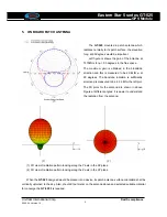
Page 9: ...he antenna above and selected suitable material for converge the GT 525 if is required The GT 525 mounted a patch antenna which radiates normally to its patch surface the elevation for at 90 degrees w...

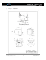
Page 10: ...UniTraQ International Corp RoHS compliance 2009 04 Version 1 2 7 Eastern Star 5 series GT 525 GPS Module 6 MECHANIC DIMENSION...

Page 11: ...100 5204 Longitude in dddmm mmmm format Leading zeros transmitted 5 E W Indicator E Longitude hemisphere indicator E East W West 6 GPS quality indicator 1 GPS quality indicator 0 position fix unavaila...

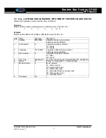
Page 12: ...ple Description 1 Latitude 4250 5589 Latitude in ddmm mmmm format Leading zeros transmitted 2 N S Indicator S Latitude hemisphere indicator N North S South 3 Longitude 14718 5084 Longitude in dddmm mm...

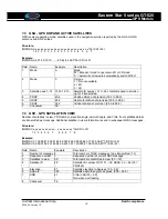
Page 13: ...ion 00 0 to 99 9 6 VDOP 32 2 Vertical dilution of precision 00 0 to 99 9 7 Checksum 0A 7 4 GSV GPS SATELLITE IN VIEW Number of satellites in view PRN number elevation angle azimuth angle and C No Four...

Page 14: ...Data Valid 3 Latitude 4250 5589 Latitude in dddmm mmmm format Leading zeros transmitted 4 N S indicator S Latitude hemisphere indicator N North S South 5 Longitude 14718 5084 Longitude in dddmm mmmm...

Page 15: ...9 4 Speed 0 00 Speed over ground in kilometers per hour 0000 0 1800 0 5 Mode A Mode indicator N not valid A Autonomous mode D Differential mode E Estimated dead reckoning mode M Manual input mode S S...

Page 16: ...tion at any time without notice These materials are provides as is without warranty of any kind either expressed or implied relating to sale and or use of UniTraQ products including liability or warra...

Reviews: