GeoCOM Reference Manual
GeoCOM
Leica TPS1200 / TS30 / TM30 – Version 1.50
6
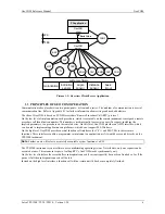
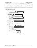
Picture 1-1: Overview Client/Server Application
1.3
PRINCIPLES OF GEOCOM OPERATION
Communication takes place between two participants - a client and a server. The medium of communication is a serial
communication line. Refer to Appendix B for further information about settings and needed hardware.
The idea of GeoCOM is based on SUN Microsystems’ Remote Procedure Call (RPC) protocol.
On the low level of implementation, each procedure, which is executable on the remote instrument, is assigned a remote
procedure call identification number. This number is used internally to associate a specific request, including the
implicit parameters, to a procedure on the remote device. On this level, GeoCOM provides an ASCII interface, which
can be used to implement applications on platforms, which do not support MS-Windows.
On the high level, GeoCOM provides normal function call interfaces for C/C++ and MS-VBA to these remote
functions. These interfaces enable a programmer to implement an application as if it would be executed directly on the
TPS1200 instrument.
Note:
Further on we will refer to a remotely executable system function as a
RPC
.
The TPS1200 instrument system software uses a multitasking operating system. Nevertheless, only one request can be
executed at once. This means in respect of calling RPC’s GeoCOM works synchronously only.
On the low level interface the server buffers subsequent requests if current request(s) has not been finished so far. If the
queue is full then subsequent requests will be lost.
Instead on the high level interface a function call will not return until it has been completely finished.
system software
SUP
BMM
MOT
TMC
CSV
AUT
BAP
EDM
PC application
GeoCOM
server
inclination
sensor
angle
sensor
distance
sensor
motorization
basic
in/out
COM
GeoCOM
client
COMF
Serial Line
TPS
PC
CTL


