C
ONFIGURATION
C
OMMAND
S
ET
- F
IRMWARE
R
EVISION
2.4.0_
BETA
-
V
ERSION
1.0.0
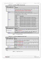
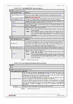
Specifies the radius of the circle, in meter. When the device
enters into such Geofencing zones, the firmware compares
the calculated angle between the centre of the specified
circle (longitude, latitude) and altitude with the current
position of the device rather than the given radius value.
That means if the altitude is given wrong and does not
match the altitude where the circle is set, results a wrong
calculation of the radius, so false alarms may be activated.
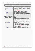
R,
Creates a square/rectangle
shape. Based on the longitude and latitude it allows you
to restrict a zone you want to determine on the earth. The
la_min, lo_min
and the
l
a_max, lo_max
coordinates of the
rectangle are required to defines the zone.
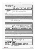
<
la_min
>
Specifies the min. latitude value in decimal format.
<
lo_min
>
Specifies the min. longitude value in decimal format.
<
la_max
>
Specifies the max. latitude value in decimal format.
<
lo_max
>
Specifies the max. longitude value in decimal format.
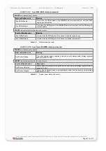
How to set/get GF configuration:
Set
configuration
$PFAL,Cnf.Set,GF1=area8000,"Falcom Office",
R
,50.673400,10.980600,50.673500,10.980700
$PFAL,Cnf.Set,GF1=area8000,"Falcom Office",
C
,50.673400,10.980600,482,100
Get
configuration
$PFAL,Cnf.Get,GF1
Example 1:
This represents how to cover up a driving route using several Geofences within just
an area. The purpose of such configurations is to notify users whenever the
MAMBOII device enters/exists a GeoFence or only when it enters/exits an area -
features for arrival/departure notifications.
As a reference use the diagram
attached to this example (fig. 8).
For example, you have configure just one area (e.g.
GF.AREA4
) with following
settings:
GF.AREA
4
=”City”
//corresponds to hex value
10
(10000)
Later on, based on the area settings you may configure the GeoFences that will
be attached to.
GF1= area
10
,"B88",R,50.673400,10.980600,50.673500,10.980700
GF
2
= area
10
,"Street 1",R,….
GF
3
= area
10
,"Street 5",R,….
GF
4
= area
10
," B104",R,….
GF
5
= area
10
,"Street 256",R,….
Whereas all GeoFences
GF1, GF2, GF3, GF4
and
GF5
belong to the area
GF.AREA
4
,
so
that the set value of
area<flag>
is the hexadecimal values of
GF.AREA
4
(^=10)
corresponding to
area
10
.
This confidential document is a property of FALCOM and may not be copied or circulated without previous permission.
Page 203 of 271


